


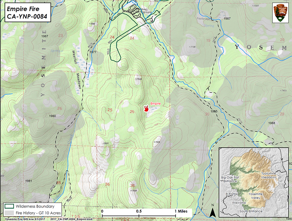
Empire Fire: N 37° 38.673' x W 119° 37.096' at approximately 7300 feet elevation
Size: 147 acres
Cause: Lightning
The Empire Fire is in the wilderness and reported on the night of July 31st. This fire is being managed for both protection and resource objectives as allowed in Yosemite's Fire Management Plan. It is approximately 1 mile south of the Bridalveil Campground and between Alder Creek and Bridalveil Creek on a north-northeast aspect with an over story of red fir. Current fire behavior is creeping and smoldering in needle duff, burning in heavy dead and down timber, and backing and flanking on the NW and NE sections of the fire.
Fire crews are on scene today doing an assessment of the fire. There is no immediate threat to the Bridalveil Campground, Alder Creek trail, and Bridalveil Creek trail. Future closures will be decided based on fire behavior.
Starr King Fire: N 37° 42.965' x W 119° 29.588' at approximately 7800 feet elevation
Size: less than one quarter acre
Cause: Lightning Strategy: Monitor, no threat to Little Yosemite Valley
Blue Fire: In the Blue Jay Creek Drainage at approximately 8800 feet elevation
Size: less than one quarter acre
Cause: Lightning Strategy: Monitor
Jay Fire: In the Blue Jay Creek Drainage at approximately 8800 feet elevation
Size: less than one quarter acre
Cause: Lightning Strategy: Monitor
Porcupine Fire: N 37° 49.336' x W 119° 34.720' at approximately 8050 feet elevation just off of Hwy 120 near Yosemite Creek Campground road
Size: less than one quarter acre
Cause: Lightning
Indian Canyon Fire:at approximately 7400 feet elevation half a mile from the north Rim Trail
Size: 1/2 acre
Cause: Lightning Strategy: Initial attack will be suppression
North Dome Canyon Fire:N 37° 45.655' x W 119° 33.571' at approximately 7600 feet elevation off the Indian Ridge Trail below the ridge.
Size: 1/4 acre
Cause: Lightning Strategy: Initial attack will be suppression
For additional Information:
- Fire Information: Yose_Fire_Info@nps.gov
- Yosemite National Park Fire Information website: http://www.nps.gov/yose/blogs/fireinfo.htm
- Facebook: http://www.facebook.com/pages/Yosemite-Wildland-Fire/124632964255395
- Twitter: https://twitter.com/YosemiteFire
- Air Quality: https://www.nps.gov/yose/learn/nature/aqmonitoring.htm
Source: NPS

