


Size: 850 acres
Cause: Lightning
August 13, 2017 - Yosemite National Park fire and aviation crews have responded to multiple lightning-caused wildfires located within the park boundary.
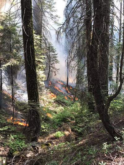
Lightning-caused wildfires are a common occurrence. There have been a total of 10 lightning-caused wildfires since July 31, 2017. One fire currently in monitor status is the Empire Wildfire. Which is currently being managed for resource and protection objectives.
Monitoring a wildfire is a fire management tactic used by fire managers when strategizing an incident response, and contributing factors that help steer this decision-making process are often incident specific. Location, available resources, predicted weather, topography, air quality and predicted fire behavior are all factors that contribute to fire management decisions.
Basic Information
| Current as of | 8/12/2017, 7:04:35 PM |
|---|---|
| Incident Type | Wildfire |
| Cause | Lightning/natural |
| Date of Origin | Tuesday August 01st, 2017 approx. 08:45 AM |
| Location | 1 Mile South of Bridalveil Campground in Yosemite's Wilderness |
| Incident Commander | Jeff Pirog, IC, Jacob Gear ICT Yosemite, Type 3 |
| Incident Description | Management |
Current Situation
| Total Personnel | 33 |
|---|---|
| Size | 850 Acres |
| Fuels Involved | Red Fir Timber (Litter and Understory), Dormant Brush, Hardwood Slash Pockets of green leaf manzanita and chinquapin brush as well as heavy dead and down material |
| Significant Events | Trails are closed from Bridalveil Creek campground to the second junction with the Ostrander trail. Additionally, from Westfall Meadow to the Deer Camp junction, along Alder Creek remains closed. Signs are placed at the affected trails. There are no threats at this time to infrastructure at Bridalveil Campground and the remainder of hiking trails in the area remain open at this time. |
Outlook
| Planned Actions | Continue to hold and improve existing trails and lines. |
|---|---|
| Projected Incident Activity | 12 hours: The southwest side of the fire continues to work it's way south along Alder Creek Drainage. 24 hours: Crews will continue to improve hand lines as needed and conduct firing operations as needed along existing lines. 48 hours: Same 72 hours: Contingency work will begin on Highway 41 south of Chinquapin down to Alder Creek. |
Current Weather
| Weather Concerns | Little diurnal change in temperatures an |
|---|

Source: NPS
Earlier Information: Lightning Caused Empire Fire in Yosemite National Park Grows to 750 Acres – Trail Closures in Effect

