


South Fork Fire Map - Yosemite National Park
August 14, 2017 - A Monday morning August 14, 2017 update on the Wildfires burning in Yosemite National Park
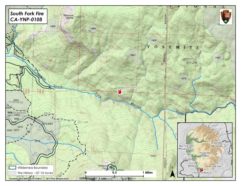
South Fork (Click here for more information)
Size: 400 acres / Elevation 5,100' / Location 37 32.258 x -119 35.902 1 mile east of Wawona
South Fork of the Merced drainage, south of Wawona Dome. Air resources on scene and suppression operations are in progress. Rangers have closed Chilnualna Falls trail at the bottom. Fire is visible from the Swinging Bridge area. Rangers have begun door to door notifications for pre-evacuation.
Multiple resources from Yosemite and adjacent communities. Joint effort with all park staff and divisions.
Empire (Click here for more information)
Size: 1200 acres / Elevation: 7,272’ / 80% of the perimeter is active burning in Red fir.
Fire burned actively today with good smoke dispersal to the north-northeast. Trails are closed from Bridalveil Creek Campground to the second junction of Ostrander trail. Additionally from Westfall Meadow to the Deer Camp junction, along Alder Creek remains closed. Signs are placed at the junctions by crews. Day-use hikers are being escorted by fire personnel at the trail near Bridalveil Creek.
Engine 32 is on the Bridalveil side of the fire and there is a new spot that is going to add .6 miles of additional trail closure. Both the trail closure and the spot are west of the creek proper. The continuation will be from the current closure to the next intersection to the south.
The crews on scene will continue to monitor fire behavior and smoke dispersion as well as assessing potential holding areas around the fire planning area.
Starr King
Size: 3 acres/ Elevation: 7980’ / Fuels: Red fir and Lodge Pole. Monitored.
2-3 foot flame lengths with flames visible from Subdome. Fire is triangular shaped and active flames on both flanks. Moving uphill - made 300 foot upslope progress. Smoke is more visible than in days past, rising 300-400 ft agl and dispersing south and east.
Yosemite Creek
Size: 0.16 acres / Size: less than one quarter acre / Fuels: Red fir
(.04 acre growth) 60% active perimeter with main activity to east and northeast. Creeping and smoldering in duff, litter and heavies with moderate spread potential and 2-3 ft flame lengths in the heavies. Continues to back downhill with increase in smoke production this afternoon. Smoke rising 300 ft agl and dispersing north. Continue to monitor activity and spread potential.
E-1130 monitoring this fire. Spike camping at the top of campground road.
Knob 91
Size: .039 acres / Elevation: 8980' / Fuels: Timber litter
20% active perimeter. Engine 1130 will be monitoring this fire. Moderate creeping and smoldering. Minimal smoke production. Will continue to monitor fire behavior. Minimal growth on east aspect
Porcupine
Size: 1.32 acres/ Elevation: 8154’ / Fuels: Lodge Pole and Red fir. Engine 1130 monitoring.
Update from Engine 1130: The Porcupine Fire has a 1/3 acre growth, bringing the new total to 1.32 acres. The fire has a 50% active perimeter, with primary movement to the west. Fire behavior is smoldering and creeping in duff and litter within 100 and 1000 hour fuel with single tree torching. The smoke is dissipating at 700 foot AGL to the Northeast, most active at 1400 with low RH for the day at 12%. The current plan is to monitor behavior and spread potential.
Benson Pass
Size: less than one quarter acre/ Elevation: 10,043' / Fuels: White Bark
Unstaffed.
Source: NPS

