


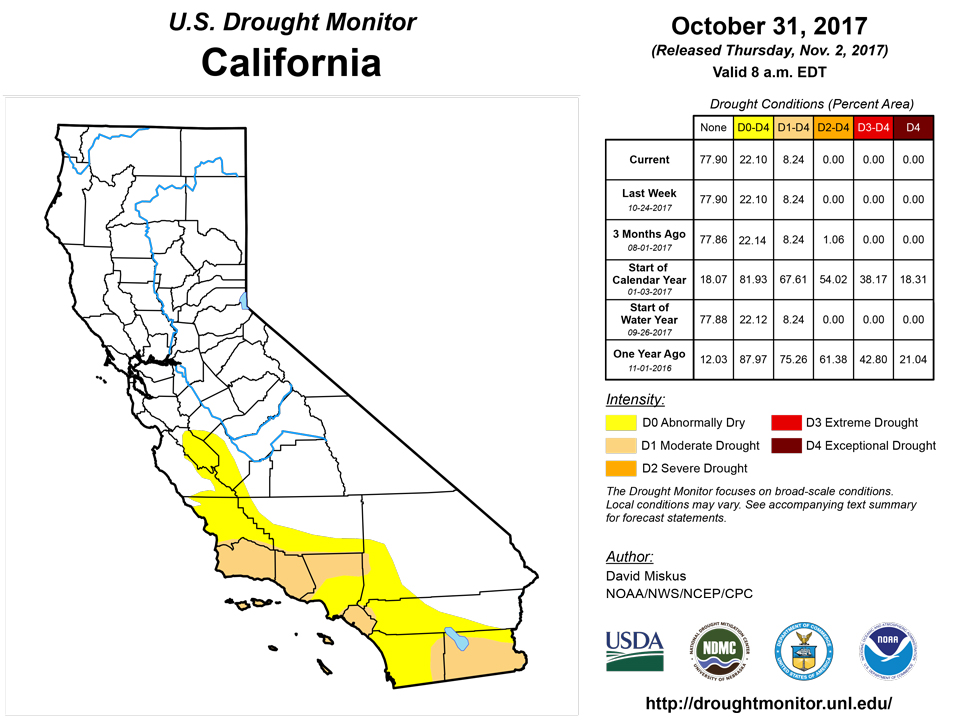
California and National Drought Summary for October 31, 2017
Summary
November 2, 2017 - A series of storm systems traversed from the Canadian Prairies southeastward across the eastern half of the Nation during the week, with a strong weekend storm tapping ample tropical moisture from the Gulf of Mexico, the Caribbean Sea, and disorganized Tropical Storm Philippe that was eventually absorbed into the system. With plentiful moisture available to the weekend storm system, widespread, copious rains (2-6 inches, locally to 12 inches) inundated most of the Northeast, especially New England, abruptly ameliorating short-term deficits accumulated during the late summer and fall months. Heavy rains also fell on southern Florida (from Philippe), while light to moderate precipitation occurred in the Great Lakes region, Ohio and Tennessee Valleys, and the Appalachians. With high pressure entrenched over the West, little or no precipitation was reported west of the Mississippi River. Temperatures averaged well below normal east of the Rockies and to the Appalachians, especially in the South and Midwest that had weekly departures of -6 to -12 degF. Sub-freezing readings were common across the northern and central Plains and Midwest, along with decent snows in the upper Midwest. In contrast, above-normal temperatures prevailed across the West and New England. Showers frequented the Hawaiian Islands during the week, maintaining a recent wet pattern that allowed for additional improvements to some windward locations.Northeast
According to the AHPS and RFC precipitation networks, more than 4 inches of rain (locally to 12 inches) fell on much of New England, especially from Long Island, Connecticut, and Rhode Island northward through Massachusetts, eastern Vermont, New Hampshire, and much of Maine. The rains were quite beneficial as it fell on areas that had recently gone into moderate drought and had lingering long-term deficits going back as far as 1-2 years. Heavy rains (2-6 inches) also occurred in most of New York, New Jersey, central and extreme eastern Pennsylvania, the Delmarva Peninsula, western Maryland, and eastern West Virginia and western Virginia (central Appalachians). Moderate totals (1-2 inches) were reported in western and east-central Pennsylvania, extreme western New York, and central Maryland. Not surprisingly, most 1- and 7-day averaged USGS stream flows were near or at record high levels, with lower percentiles (but still mostly above-normal levels) at 14- and 28-day averages due to the short-term dryness during early and mid-October. As a result, 1 and 2-category improvements were made in most areas, with all D1 erased in New England, leaving some residual D0(L) in central Vermont and along coastal Maine where weekly totals were lower and 60 to 90-days deficiencies remained. A 2-category improvement (D1 to nothing) was made in northern New Hampshire, northwestern Maine, Connecticut, Rhode Island, and central Massachusetts where amounts exceeded 6 inches. Elsewhere, D0 was removed from Northeast locations, except in extreme western Pennsylvania and central Maryland where lingering short-term shortages at 2- and 3-months and lower storm totals (1-2 inches) were not quite enough to erase D0 there.Southeast
Storm totals were much less in the Southeast as compared to the Northeast, although moderate to heavy (2-4 inches) rains fell on the Appalachians – which came on top of decent rains (2-4 inches) last week. Small surpluses have replaced short-term deficits (at 60- and 90-days), while average USGS stream flows at 1, 7, 14, and 28-days were all near to much-above normal. Accordingly, D0 was removed in the central Appalachians of western Virginia, eastern West Virginia, and northeastern Tennessee. Elsewhere, parts of eastern sections of Virginia and North Carolina measured between 1-3 inches of rain, while light to moderate (1-2 inches) precipitation was observed across Tennessee, northern Alabama, northern Georgia, extreme western South Carolina, and southern Florida. The rains were enough to reduce or eliminate short-term deficits or improve stream flows (D0 erased) in the James River Basin of eastern Virginia while the eastern portion of the D1 area in central North Carolina was improved to D0. In contrast, little or no rain fell on south-central Virginia, central North Carolina, central and eastern South Carolina, southern Georgia, northern and central Florida, and southern Alabama. After some improvements were made last week in the D0 areas of the Piedmont region, the only areas of deterioration were new D1 areas in south-central North Carolina and north-central South Carolina where both 60- and 90-day precipitation was between 50-70% of normal. Similarly, the D1 area in north-central North Carolina and south-central Virginia was adjusted slightly westward to align with lower percentages. In northwestern Alabama, enough rain (1-1.5 inches) fell to eliminate short-term deficiencies in Marion County.South
In southeastern Texas and southwestern Louisiana, a conundrum exists between the depiction of very dry conditions at 60-days versus excessive wetness at 90-days from Hurricane Harvey’s rains and subsequent flooding. For now, the 90-day wetness won out over the 60-day dryness in southeastern Texas and southwestern Louisiana due to the significant surpluses in this area at 90-days and beyond, near-normal USGS stream flows, and wet subsoil moisture - hence no D0 designation (yet). Farther to the north, however, from northern Louisiana northward into southern Missouri, there is no question that the low percent of normal precipitation and subsequent deficits at 60- and 90-days (5-50% and 5-10 inch; 35-70% and 2-8 inch deficits, respectively) deserve at least D1 as Harvey’s copious rains did not reach this far west and north. Fortunately, good early August rains have tempered the recent dryness, or 90-day conditions would be much worse here. Elsewhere, enough rain (0.5-1.5 inches) fell on eastern Louisiana, eastern Arkansas, Mississippi, and Tennessee to prevent deterioration of conditions, but not enough to provide improvement. A small exception to this was some minor degrading from D0 to D1 in northern Louisiana and south-central Arkansas where the rains missed. In western sections, a dry week in Texas and Oklahoma was enough to expand D0 across parts of southwestern, west-central, and extreme southern Texas and north-central Oklahoma, along with some small areas of D1 and D2 increases. Northeastern Texas and eastern Oklahoma remained the same after improvements last week from beneficial rains. In addition, the remaining areas of the southern Plains were status-quo even with this week’s dry weather due to decent rains during the past 1-2 months, although well below-normal temperatures also helped.Midwest
The fall is a good time for soil moisture recharge before the ground freezes as lower temperatures, little or no evapotranspiration, no crop moisture uptake, and steadier, longer, lighter rains (less thunderstorm downpours that run off) tend to maximize the rains benefits of increasing the soil moisture content and positive hydrologic impacts. With that mentioned, although the late summer and early fall were dry, October has been mostly wet across much of the Midwest, and ground-truth measurements of soil moisture profiles in central and southern Illinois have shown a strong recovery in soil moisture at several depths (5, 10, 20, and 50 cm). Accordingly, even though precipitation was generally light this week (0.3-1.2 inches) across Illinois, Indiana, Ohio, and central Wisconsin (but temperatures well below normal), some small 1-category improvements were made in these states where decent October surpluses occurred even though 60- and 90-day negative SPIs and deficits existed. Similarly in northeastern Missouri, although this week was dry, some D1 was chipped away based upon surplus October rainfall. In lower Michigan, the small D0 was removed as heavier totals (1-2 inches) fell this week. In contrast, drier 60- and 90-day conditions in southern Missouri plus no rain this week slightly expanded the western and eastern borders of the D1. In northeastern and northwestern Ohio, weekly precipitation was less than the rest of the state (between 0.2-0.5 inches), and with October closer to normal, D0 and D1 was left intact in those two areas. In contrast, greater weekly totals (0.7-1.1 inches) and surplus October precipitation allowed for improvement in north-central Ohio.High Plains
After several weeks of modifications to the northern Plains (mostly improvements but some deterioration), little or no precipitation fell this week – which is normal for the fall and winter months in the northern Plains. In addition, weekly temperatures averaged near to below normal, along with widespread sub-freezing readings, basically ending the growing season. With typical precipitation (dry), cool temperatures, little or no evapotranspiration or plant growth, no major changes were made in the High Plains this week. Two small exceptions included extending D0 into eastern areas of North Dakota and northwestern Minnesota as a dry October accumulated enough deficits at 60- and 90-days in a slightly wetter climate regime (D0 into Pembina, Steele, and Traill counties of ND and Kittson and Polk counties of MN).West
Tranquil conditions returned to the West after last week’s stormy and wet weather in the Northwest. Little or no precipitation and above-normal temperatures were the rule in the West as upper-air ridging enveloped the region. With improvements made to the Northwest last week, no changes were made there this week. Farther south, however, persistently dry and warm weather over the past several months, including a weaker than normal summer monsoon and early ending in Arizona and Utah, along with increased evaporative demand, has started to portray negative impacts. In west-central Arizona (D0 added), a poor monsoon and long-term negative anomalies has started to affect reservoir levels and recreation. In northeastern Arizona, D0 was expanded and D1 was added as soil moisture data showed shallow and deep moisture profiles falling to their lowest level in a year. Ranchers were hauling in hay as any natural forage is dead or dormant. D1 was expanded northward into south-central Arizona due to lack of rain past 60-days, poor growing conditions, numerous small brush fires occurring out of season, and ranchers bringing in hay. D2 was added in extreme southern Arizona (Santa Cruz, southeast Pima, and southwest Cochise counties) as farmers and ranchers reported extremely poor conditions and only half of the year-to-date rainfall. All typical forage is dead or dormant, and Patagonia Lake is down 4 feet from normal (versus 3 feet low last year). D0 was also expanded into south-central Utah and D1 in southeastern Utah with similar conditions in neighboring northern Arizona. In southwestern Colorado, even though the indices at 2-6 months were similar to the adjacent D1 area in southeastern Utah, ground reports indicated much better conditions in Colorado than in neighboring southeastern Utah, so no D1 was drawn.Alaska, Hawaii, and Puerto Rico
There were significant rains over many areas of the state due to a frontal passage. But since many of the drought affected areas involve agricultural drought, it is too soon to declare widespread drought reduction. Additional rains will be needed for more widespread and definitive improvement as several stream flows have already reverted back below the 25th percentile level, indicating that base flow still has a ways to go before full recovery. However, some improvement is warranted in windward locales, including: trimming D0 in northeastern Kauai while tightening up the D-x gradient over southern sections; trimming the D0 over northern and eastern Oahu except for keeping D0 over the central Koolau Range; erasing D0 from Lanai; removing D0 over northeastern slopes of Haleakala on Maui, and going from D1 to D0 in east-central Maui as the Maui County Department of water Supply removed the voluntary water conservation notice; and erasing the D0 from the Big Island’s lower windward slopes. No changes were made on Molokai.Moderate to heavy precipitation fell across the southern third of Alaska while light to moderate showers (1-3 inches) were reported on Puerto Rico. This week’s precipitation assured that no new dryness or drought was warranted in either Alaska or Puerto Rico at this time.
Looking Ahead
During the upcoming 5-day period (November 2-6), a potent Pacific storm should drop decent precipitation (1-5 inches) on most of the Northwest, southward into central California and the Sierra Nevada, and eastward into parts of the central and northern Rockies. Light to moderate precipitation is expected in the lower Mississippi Valley northeastward into the eastern Great Lakes region and western New England. Little or no precipitation should occur in the Southwest, central and southern Plains, and the Southeast. 5-day temperatures will average well above-normal across most of the lower 48 States except for subnormal readings in the Far West and across the northern thirds of the Rockies and Plains and the upper Midwest. Well below-normal temperatures are expected in Montana and North Dakota.During the 6-10 day period (November 7-11), odds favor above-median precipitation along the Pacific Northwest Coast, from the middle Mississippi and Ohio Valleys eastward into the Northeast, and northern Alaska. Probabilities for below median precipitation are greatest in the Great Basin, northern Rockies and Plains, upper Midwest, along the Gulf Coast States, and southern Alaska. Above-normal temperatures are likely from the Four Corners region eastward to the southern and middle Atlantic regions and in western and northern Alaska while a tilt toward subnormal temperatures were found in the southeastern Alaskan Panhandle, the Far West, and across the northern thirds of the Rockies, Plains, and Midwest
Author(s):
David Miskus, NOAA/NWS/NCEP/CPC
Dryness Categories
D0 Abnormally Dry—used for areas showing dryness but not yet in drought, or for areas recovering from drought.Drought Intensity Categories
D1 Moderate DroughtD2 Severe Drought
D3 Extreme Drought
D4 Exceptional Drought
Drought or Dryness Types
S Short-Term, typically less than 6 months (e.g. agricultural, grasslands)L Long-Term, typically greater than 6 months (e.g. hydrologic, ecologic)
Source: National Drought Mitigation Center
