


Above normal temperatures late fall/winter
Below normal precipitation possible through the “rainy season”
Near to above normal offshore wind events rest of the year.
A weak La Niña is likely through early next year.
Weather Discussion
November 6, 2017 - Heat, heat and more heat - that was the drumbeat of the weather during the past month. A strong ridge of high pressure lingered along the coast which pushed high
 temperatures to well above normal readings several times in October. The heat reached an apex on the week of the 22nd. 500 millibar heights reached over 596 dm which is more appropriate of July or August and a strong, subsident offshore wind caused temperatures to easily surpass daily records. In fact, many stations over Southern California saw their hottest readings ever for so late in the calendar year. The Los Angeles Civic Center and several other locations experienced their latest occurrence of 3 consecutive days of over 100 degrees. Oxnard and Camarillo also recorded their first ever occurrence of 3 or more consecutive 100 degree days. The heat wasn’t confined to just Southern California as the ridge was strong enough to allow record-smashing heat to occur along the central coast. Big Bear and Bay Area cities all reached 100 degrees during the same heatwave.
 At least 14 offshore wind days occurred during the past 30 days which further added to the hot, dry conditions. (October averages 6 offshore days total with 2 of them being strong.) The offshore winds kept conditions exceptionally dry with single digit RH occurring over most of the district each day for nearly half of the month. Nighttime lows were very warm in some of the windy areas as well with some locations only seeing readings drop below 90 degrees for a couple of hours each night.
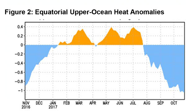
But there are signs that more favorable weather may be in the offing, at least in the short term. Sea surface temperatures, while remaining cool over the equator, are below normal over the Gulf of Alaska (Figure 1, left). This stands in contrast to the above normal SST’s in the Gulf in September. Cooler waters this this area often allows cyclonic circulation to develop in the Gulf and Pacific Northwest which is more favorable for steering storms into the West Coast.
The Pacific-North American Pattern (PNA) has rapidly dropped during the past few weeks, and at the time of this writing, is negative. A negative PNA along with cooler than normal SST’s in the Gulf is much more conducive for the production of precipitation in California. As long as these factors remain in place, there may be periods of beneficial wetting rains during the first half of November. But these PNA patterns usually do not last long and the index may trend more unfavorably toward the end of the month. So, even through November may start off quite wet, it should not be necessarily taken as a sign of a wet winter.
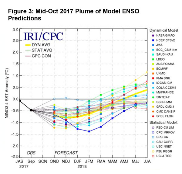
Most long range models guidance indicates that a weak to moderate La Niña will be in effect through the summer (Figure 3, below). This often (but not always) leads to below normal precipitation for California, especially Southern California. The models have been trending more negative during the past few monthly forecasts which may be a function of the rapid cooling of SST’s and near surface temperatures along the equator (See above). The climate prediction center is still projecting a 55- 65% chance of a La Niña this winter and a La Niña watch remains in effect. Therefore, a negative ENSO signal is likely to be one of the primary drivers of the weather pattern this winter.
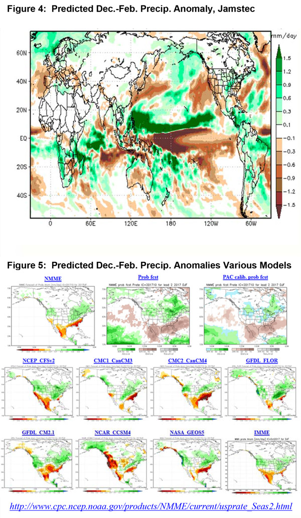
With the exception of NASA’s long range model, all other available guidance point to a warmer and drier winter than average (see figures 4-5, below). Of note is the Jamstec model from the Japan Agency for Marine-Earth Science and Technology which was one of the models that seemed to pick up on these trends first. This model keeps the entire state in a drier than normal pattern during the peak winter months of December through February. It may be overstating the dryness over the northern part of the state into the Pacific Northwest, but confidence of a drier than normal winter is high over Southern California.
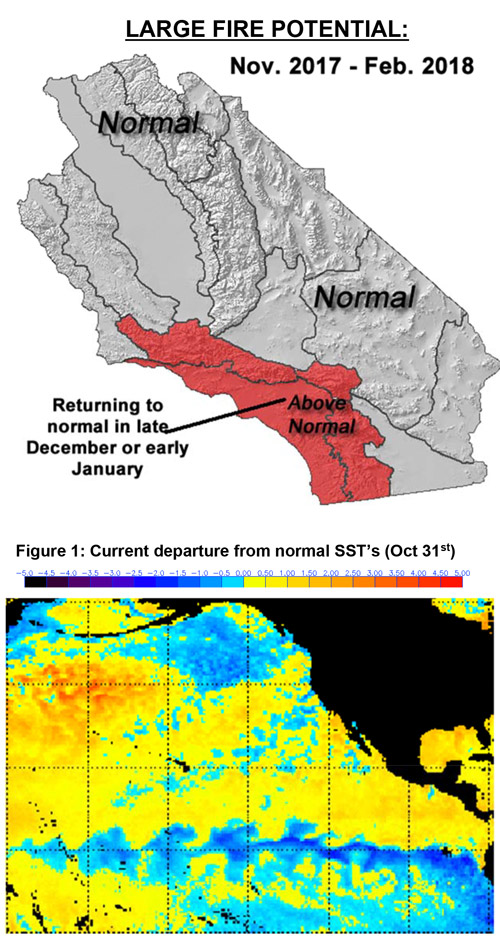
The expectation of a warmer and drier than normal winter may keep the southern part of the state in above normal large fire potential for several more weeks. Significant and meaningful enough wetting rains may wait until the end of the year to overcome the present extremely dry fuel conditions. The rest of the district should see large fire potential ease from north to south. Offshore wind events are expected to continue at an above normal rate, albeit not quite as high a frequency as what occurred in October.
Fuels and Drought Outlook:
A return of a La Niña stacks the meteorological deck against another wet winter. If the model consensus is correct, this winter will be drier (and possibly much drier) than average. This may result in a winter in which new starts occur during months which ordinarily do not see much activity. The Colby Fire of January 2014 is an example of a large incident which occurred “out of season” during a La Niña winter (ENSO conditions that year were weakly negative as is expected this winter). Therefore, there may be some IA and resource demand over Southern California during warm and windy periods this winter.
Some re-emergence of the drought seems likely over the state this winter. Portions of Southern California are already in a D1 (moderate) drought and this situation is unlikely to improve in the long term. It is more likely that the drought will worsen in both areal coverage an intensity by spring.
Fortunately, last winter’s heavy rain and snowfall and its resultant filling of reservoirs provides some insurance against the drought for agricultural interests and others dependent on the state’s water projects. At the current time, reservoirs are still over 100% of historical average and are still at least 50% of total storage heading into the winter. But look for lake and reservoir levels to fall to below average this winter. This spring may see a return of water restrictions in a few places.
Should this winter be drier than normal as expected, this would mark the 6th dry season out of the last 7 which were dry. Further die-off and plant mortality may result, furthering the loading of dead fuels across the district. An increase in dead fuels may play a role in fire behavior during future fire seasons.
Source: Predictive Services

