


Above normal temperatures this winter.
Below normal precipitation expected with the greatest precipitation deficits occurring in Southern CA.
Above normal offshore wind events rest of the year.
A weak to approaching moderate strength La Niña through early next year.
Weather Discussion
December 4, 2017 - After torrid conditions in October, temperatures approached normal readings for the balance of November with one notable exception during the 3rd week of the month. Turkeys weren’t the only things roasting on Thanksgiving this
 year; temperatures during the 21st-24th were close to 30 degrees above normal over portions of the state. Southern California saw readings reach the mid and upper 90s as a strong ridge of high pressure and weak offshore flow gripped the area. But cooler weather returned to close out the month.
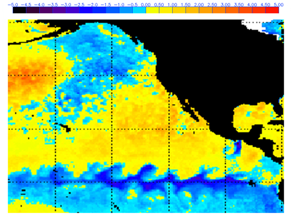
 Precipitation was below normal to far below normal across most of the district. Only the Sierras from Tuolumne County northward saw near normal amounts of precipitation in November (Figure 1, left). The driest conditions continued to be centered over Southern California where most locations did not experience a significant wetting rain (1” or greater).
The state, as well as the West Coast, continued to be bisected by wet weather over the Pacific Northwest to extremely dry conditions over Southern California last month. The line of demarcation was very well defined unlike other recent years where there is a more gradual tapering of percent of normal precipitation as one goes south. So far this season, there is a sharp precipitation gradient running roughly from Monterey County northeastward to Mono County. South of this line, precipitation has been below normal with the greatest deficits near the border with Mexico.
This is a classic precipitation distribution often seen during a mature La Niña. More often than not, during a La Niña winter, precipitation over the Pacific Northwest is above normal while the Southwest remains drier and somewhat warmer than normal. Although the current ENSO index is only slightly negative (Figure 3, below), sea surface temperatures along the equator are expected to trend cooler in coming weeks which should send the ENSO index deeper into the La Niña classification. The overall trend has been toward a cooler prediction by the models and this winter’s La Niña may end up being stronger than the one seen in the current forecast plume.
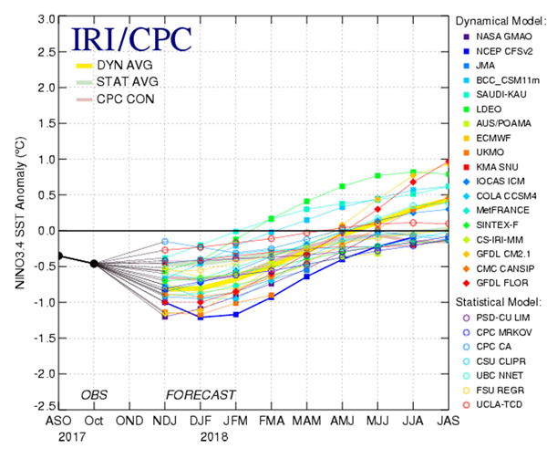
Figure 2: Current departure from normal SST’s (Nov.)
While the strengthening La Niña does not bode well for precipitation, there may continue to be a greater than normal number of troughs entering the West Coast compared to recent La Niña winters. Colder than normal SST’s over the Gulf of Alaska may continue to keep cyclonic motion in place west of British Columbia which may allow storms to develop over the Pacific Northwest. Other winters saw the opposite SST condition (the “Triple RRR”) which kept troughs very few in number.
The downside of having a greater than normal number of troughs enter the west is that it may enhance the number of offshore wind events this winter. Cold air advection occurring over the Great Basin and the Rockies may allow for a higher number of offshore pressure gradients. The Pacific Decadal Oscillation (PDO) has been trending negative during the past few months and is now at its lowest value since 2013. A negative PDO also has a tendency to result in drier and warmer than normal conditions over the Southwest.
Local research indicates there is a slight correlation between a greater than average number of offshore wind events and a La Niña. Using some locally available climatological factors, there is a greater than average chance of an increase in offshore wind events compared to recent years.
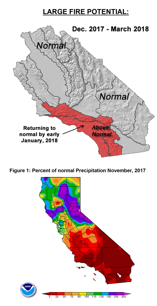
Therefore, given the current SST profile across the Eastern Pacific, and a downward trend in the PDO, a warmer and drier pattern is expected during the next 4 months. Unfavorable temperature and precipitation elements combined with the possibility of a greater than normal number of offshore wind events may keep large fire potential above normal over Southern California past the first of January. Large fire potential is expected to remain closer to normal with only a remote possibility of IA across most of Central California.
Figure 3: Mid-November, 2017 Plume of Model ENSO Predictions
Fuels and Drought Outlook
Fuel moisture values are below normal over most the area. Only a few areas of the northern Sierras have seen fuel moisture recover at lower elevations. Across the higher elevations, snowpack has fared a bit better compared to normal, but amounts are still skimpy except for the alpine areas. No snow exists currently outside the Sierras, including the mountains of Southern California.
The lack of rain so far this season places fuel moisture conditions at the whims of changeable weather. Long nighttime hours and a low solar angle will allow some smaller diameter fuels to see moisture recover a bit during cooler and more humid periods. But warm and dry weather will cause these fuels to quickly become receptive to ignitions. New starts will be able to churn through dead fuels during warm and windy periods over Southern California as no new growth has occurred. Some greenup over Central California in the coming weeks may limit fire activity there until spring.
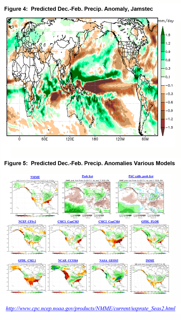
A drier than expected pattern as forecast by most of the models (Figures 4 and 5, below) may result in an increase in the coverage and severity of the drought in coming months. D1, or moderate, drought has returned to portions of Southern California recently. A D2 or worse may be possible by spring. This may result in a marked decrease in the amount of snowmelt running into area reservoirs. Last winter’s heavy snowfall has provided a bit of insurance against a dry winter, but should the dry conditions expected this winter pan out, there will be a toll exacted upon agricultural and hydrological concerns during the growing season next year.
Even though large fire potential may return to near normal levels around the start of the New Year, some initial attack may be possible even during times of the year normally not associated with large fires such as the Colby Fire in the San Gabriels, which occurred in January. Conditions may be similar to those seen in 2014 with some resource demand possible through the winter into spring over Southern California.
Source: Predictive Services

