


Above normal temperatures this winter.
Below normal precipitation expected with the greatest precipitation deficits occurring in Southern CA.
Near to slightly above normal offshore wind events rest of the winter.
A weak to approaching moderate strength La Niña until spring.
Weather Discussion
January 3, 2018 - A strong ridge of high pressure along with cold air advection over the western U.S. set the stage for a prolonged and severe offshore wind event to start the month. The windy and hot weather actually started around Thanksgiving with pressure gradients remaining offshore through the first part of December. The offshore
 winds reached their apex on Monday, December 4th when widespread wind gusts to around 80 mph were recorded across Southern California. Several large fires quickly exploded in response to the exceptionally hot, dry and windy weather. The largest of these was the Thomas Fire which destroyed 1,063 structures as it grew to become the largest fire in California history.
The wind relented slightly during the second week of the month, but temperatures remained far above seasonal averages. Very low RH also covered the entire district. It was only during the 3rd week of the month when temperatures dropped to near seasonal averages.
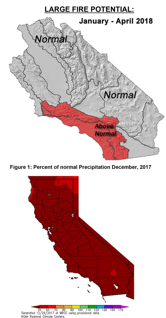
December was also unceasingly dry as the high pressure ridge off the coast thwarted any storm which approached the state. Only the Sierras saw some light wetting rains, but even there, precipitation for the month of December remained well below 25% of normal. Most of Southern California saw zero to a trace of rainfall (Figure 1, left).
While the weather was expected to be warmer and drier than normal, the severity and longevity of the heat caught most by surprise. The longwave pattern remained locked in with a strong ridge near the coast with a trough over the east coast. This pattern’s amplification during the second half of the month actually helped keep offshore winds in check as there were no storms nearby to generate northeast winds after the 15th or so.
The weather pattern has tilted strongly toward one often seen during a La Niña with dry weather developing across the Southwest. But even for a La Niña-governed pattern, this winter has been absurdly dry.
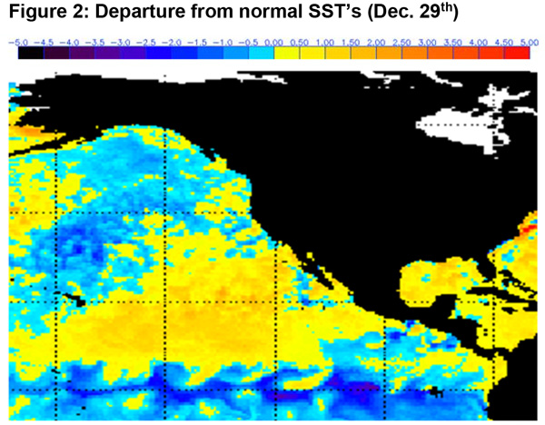
The longwave pattern across the eastern Pacific may lead to the thought that the “Triple-R” pattern of 2012-2015 had returned. There are some similarities, but sea-surface temperatures with colder than normal water over the Gulf of Alaska bear little resemblance to conditions during the peak of the “Triple-R” in 2013-2014 (Figure 2, above). Perhaps SST’s over this area have yet to warm this year in response to the ridge, but the breadth of the cold water seems to suggest such a change would be slow in coming.
The ENSO index is expected to keep trending negative for the next few weeks, which indicates the La Niña may mature in the late winter to early spring months – the climatologically wettest time of the year for most of the district.
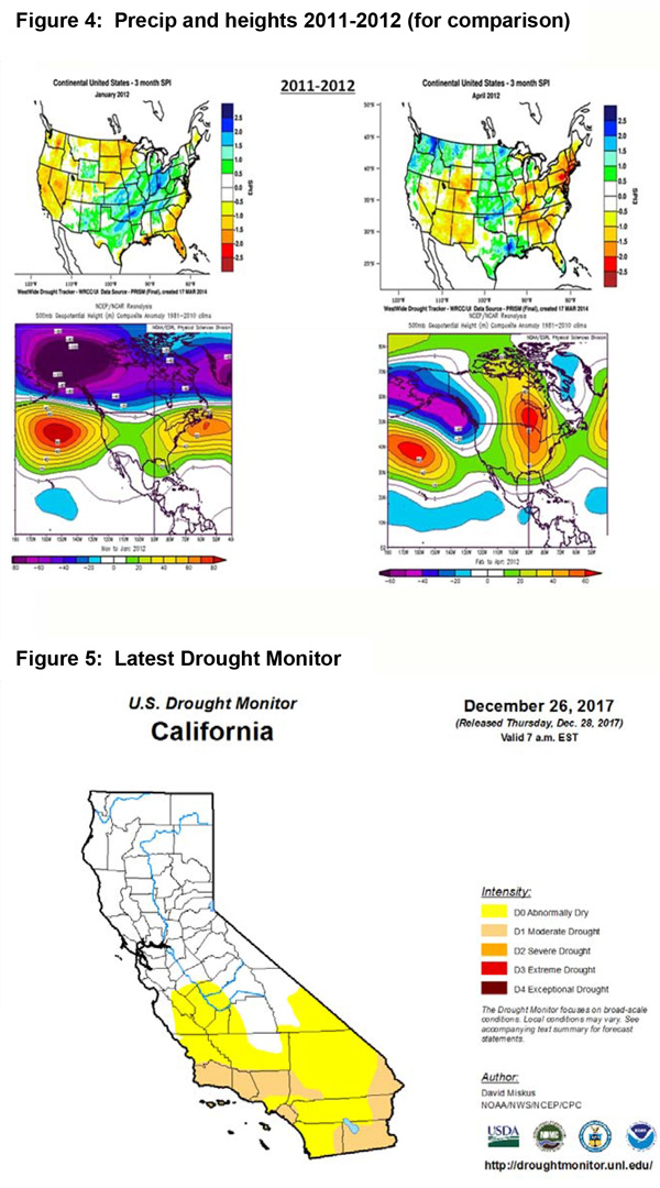
The Pacific Decadal Oscillation (PDO) remains negative at the current time. Recall, a negative PDO has a tendency to result in drier and warmer than normal conditions over the Southwest, including Southern California. This combination of a weak La Niña and a negative PDO occurred during the 2011-2012 rainy season. That season was warmer and drier than normal and for many, kicked off the severe drought which further intensified the following two years. Strong ridging that year kept the storm track split and most of the precipitation which fell ended up far north of the area (Figure 4, bottom of page).
Therefore, given the current maturing negative ENSO and a negative PDO, a warmer and drier pattern is expected to continue the next 4 months. While there will undoubtedly be some wetter periods this winter, as a whole, the winter will likely finish far drier and warmer than normal. The precipitation deficit will be most acute over Southern California. The combination of far drier than normal fuels covering the area, the expectation of warmer than normal temperatures, and the possibility of greater than normal offshore wind events, will likely keep large fire potential above normal through the rest of the winter over Southern California.

Fuels and Drought Outlook
Few Californians can recall such a punishingly dry and hot period which has occurred during the past 3 months. These hot, dry periods have also been accompanied by strong offshore wind events which have further dried the fuels. The continued lack of precipitation over Southern California has allowed fuels to dry to record low fuel moisture conditions in the dead fuels. Live fuels have been critically dry for weeks. Only the return of long nighttime hours and a low solar angle have allowed some live fuels to regain some moisture. Subsequent hot and dry periods will cause these fuels to rapidly dry back out as there isn’t any new growth or subsoil moisture to keep the plants’ moisture intact.
A D1, or moderate drought has returned to much of Southern California. The severity and coverage of this drought will likely expand rapidly during the winter and it seems almost certain that some areas will be in a D2 drought, or worse, by the end of rainy season.
Fortunately the bounty of last winter’s heavy snowpack is still being felt in terms of reservoir storage levels. Water levels remain at or above normal across the reservoirs managed by the Department of Water Resources. But a dry winter will likely add little snowmelt into these facilities.
The likelihood of a dry and warm winter will place additional stress on vegetation which has been under drought conditions for 6 of the last 7 years. Plants which were damaged by the drought may die this year if the winter turns out as dry as expected. Bark-beetle infested areas of the Sierras will be especially vulnerable. The massive die-out which began a couple of years ago may further accelerate this year.
It is possible that there may be a “precipitation rally” this spring like in 2011-2012 which may bring a brief pause in the fire activity across the state. But overall, expect some fire activity in every calendar month during 2018. Therefore, some resource demand will be possible even during the winter months…but it remains to be seen if this sort of response is the “new normal” going forward. Judging by the condition of fuels and trends in precipitation, it is the opinion of this author that the era of year-around resource demand is likely at hand.
Source: Predictive Services
