


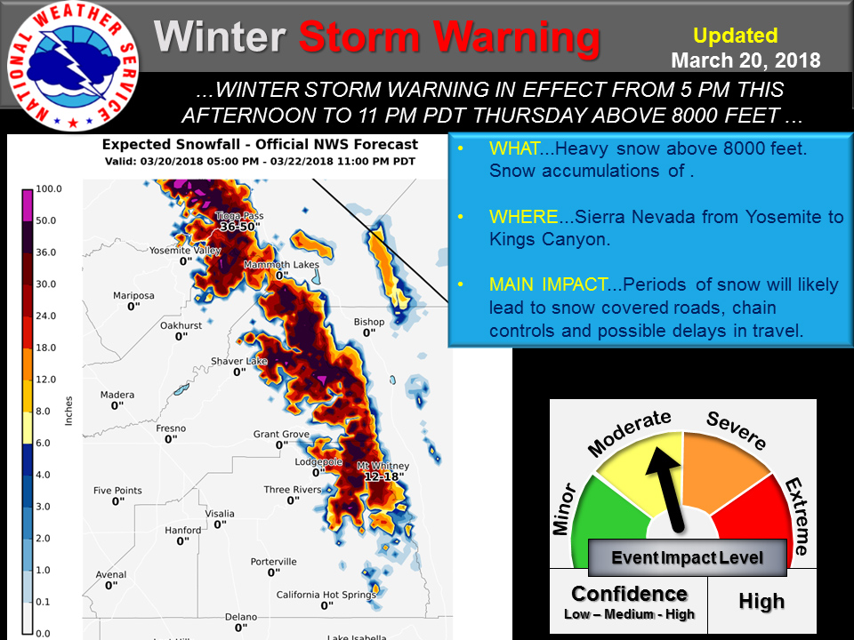
March 20, 2018 - The National Weather Service Hanford office reports a Winter Storm Warning has been issued for the Sierra Nevada above 8,000 feet from Yosemite N.P to the Kern County line.
Snow amounts of 2 to 3 feet with isolated areas of 5 feet is expected.
The heaviest snow is likely from Wednesday into Thursday morning.
Hikers and campers over the high Sierra should be prepared for hazardous wintry weather. Continue to monitor the latest forecasts.
Winter Storm Warning
URGENT - WINTER WEATHER MESSAGE
National Weather Service Hanford CA
312 AM PDT Tue Mar 20 2018

CAZ096-097-201900-
/O.UPG.KHNX.WS.A.0005.180321T0600Z-180323T0600Z/
/O.NEW.KHNX.WS.W.0006.180321T0000Z-180323T0600Z/
Sierra Nevada from Yosemite to Kings Canyon-
Tulare County Mountains-
312 AM PDT Tue Mar 20 2018

...WINTER STORM WARNING IN EFFECT FROM 5 PM THIS AFTERNOON TO
11 PM PDT THURSDAY ABOVE 8000 FEET...

* WHAT...Heavy snow expected. Total snow accumulations of 2 to 3
  feet with localized amounts up to 5 feet.

* WHERE...Sierra Nevada from Yosemite to Kings Canyon and Tulare
  County Mountains above 8000 feet.

* WHEN...From 5 PM this afternoon to 11 PM PDT Thursday.

* ADDITIONAL DETAILS...Travel will be very difficult to
  impossible. Tree branches could fall. Be prepared for
  significant reductions in visibility at times and power outages.

PRECAUTIONARY/PREPAREDNESS ACTIONS...

A Winter Storm Warning for snow means severe winter weather
conditions will make travel very hazardous or impossible. If you
must travel, keep an extra flashlight, food and water in your
vehicle in case of an emergency. The latest road conditions for
this area is 1 8 0 0 4 2 7 7 6 2 3.
Source: NWS

