


Above normal temperatures through spring.
Below normal precipitation through end of water year. Little/No additional rainfall prior to monsoon for Southern CA.
Near normal offshore wind events through May.
Active grass fire season
No clear indication regarding thunderstorm activity this summer.
Weather Discussion
April 4, 2018 - The ridge over the Eastern Pacific which had been preventing storms from reaching the state retrograded westward in March. This opened the door to allow several significant storms to finally reach California. Widespread and significant
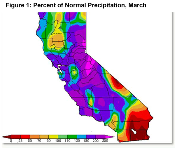
 wetting rains occurred over most of the district at the start of the month. But the weather highlight during the past month was the “atmospheric river” precipitation event of March 19th-22nd. This storm brought widespread rainfall of 3-5” with amounts over 8” along the central coast and the Sierra Foothills. The tropical origin of this storm kept snow levels well over 8,000 feet and additional snowpack was limited to the highest elevations of the Sierras. Only Orange County and portions of the Inland Empire missed this storm where precipitation continued to lag well behind normal in March (Figure 1, below)
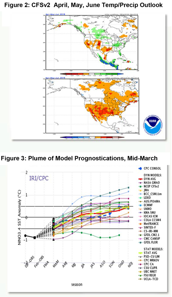
 Long term models, in general, performed well in forecasting this change to a wetter pattern in March. As far back as December, the NCEP coupled forecast system model (CFSv2) indicated a wetter finish to winter. However, this model (as well as others) point to a drier than normal spring (Fig 2 below)
By that yardstick, it seems likely that the southern half of the area will see little additional rainfall this spring. Central California may see some wetting rains continue into April, but snowpack at higher elevations has more than likely peaked for the season.
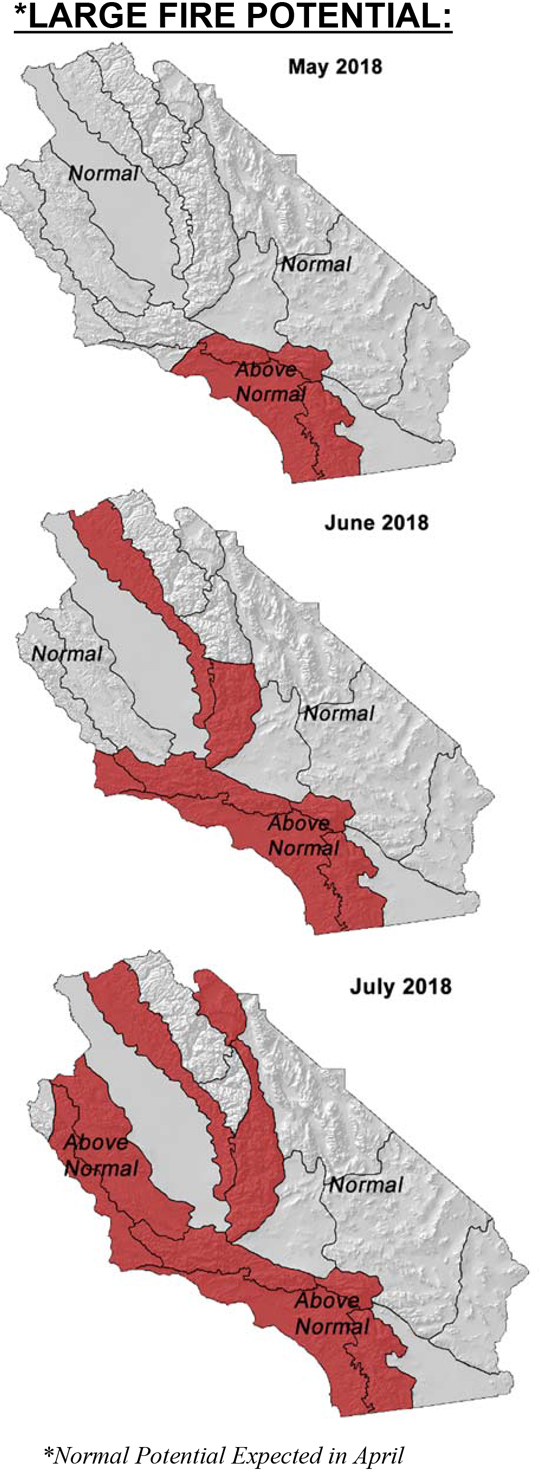
Perhaps of greater importance is the expectation of warmer than normal conditions this spring. Warmer, drier conditions with perhaps less marine layer coverage than usual would lead to strong drying conditions which may lead to a higher than normal large fire potential, once the grass crop cures. A high amount of dead fuel loading seen over many areas due to the previous drought will also serve as a good source for ignitions.
Offshore wind events have been very few in number as of late. The streak of days without Santa Ana’s or strong sundowners may continue into the first half of April, but overall, expect moderate offshore wind events to continue at the rate of 2 or so per month through the end of May. But if the pattern of the past few years returns this year, there may one strong offshore wind event sometime in May during the first week of the month.
Most members of the CPC/IRI cluster indicate a slow return to neutral ENSO conditions this spring. Therefore, sea surface temperature anomalies may play little role in determining thunderstorm proclivity this summer. Some models show an enhanced monsoon beginning in July, but there is little consensus as to whether this summer will be wet or dry.
Fuels and Drought Outlook
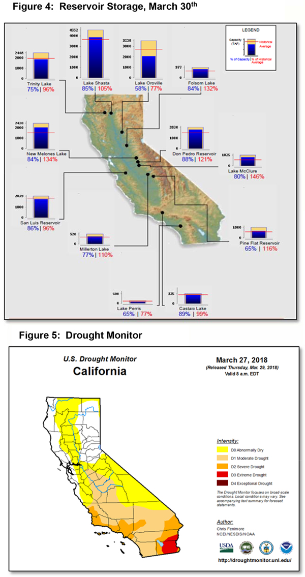
While snowpack numbers may be unimpressive when the snow survey is undertaken in early April, the heavy rains during the “atmospheric river” storm added a nice boost to reservoir storage levels. Even the San Luis Reservoir has seen levels rise to close to normal and statewide water restrictions are unlikely this year. But the absence of snow in the high country may allow heavier fuels above 9,000 feet to be available for burning toward the end of the outlook period.
The rest of the area will see large fire potential climb to above normal from south to north, starting in May (see graphic at top). Like last year, there could be a significant amount of grass fire activity this year. This is a recent development, for back in February, it appeared the grass crop this year would be rather meager. But the rains in March arrived just in time to generate a heavy and tall grass stand over many areas of Central California. The Sierra Foothills may see the heaviest amount of resource demand this spring, much like 2017.
Drought conditions which developed quickly late last year, after a pause in March, will continue to intensify and expand the next few months. The rate of drought expansion will be slow as average precipitation is very low in May and June. But by July, there will likely be many areas of Southern California in a D3 (or worse) state. An active monsoon would blunt the worst of the drought until fall, similar to what occurred in 2013-2015. But there is no solid evidence that a wet summer is in the offing, so the next period of meaningful, widespread precipitation may wait until the fall.
Source: Predictive Services
