


Statistics
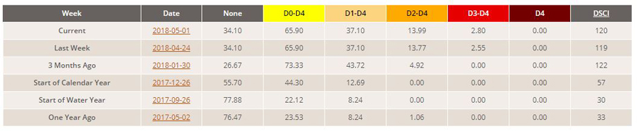
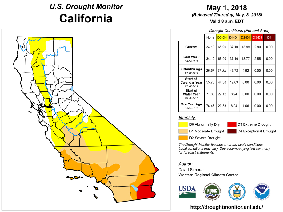
California and National Drought Summary for May 1, 2018
Summary
May 3, 2018 - This U.S. Drought Monitor week saw a series of storm systems track across the continental U.S. bringing beneficial rains to portions of the Mid-Atlantic, Northeast, and South. Out West, the storm systems brought rain and mountain snow to higher elevations as well as cooler temperatures to the northern half of the region coming into the weekend after a period of record-setting warmth across parts of the West last week. Unfortunately, the storm systems steered north of drought-stricken areas of the Southwest that saw further deterioration in conditions on this week’s map. In the southern Plains, light shower activity provided some minor relief to dry pasture and rangelands as well as helped to reduce wildlife danger. In Texas, some isolated heavy rainfall activity brought relief to the western Panhandle and Trans-Pecos region. Moving eastward, cool temperatures and scattered shower activity helped improve drought-related conditions in parts of the Mid-Atlantic and Southeast.
Northeast
During the past week, scattered shower activity was observed across much of the region with the heaviest accumulations (2-to-3 inches) centered on the Adirondacks, northern portions of New Hampshire and Vermont, and Maine. On this week’s map, some minor improvements were made in areas of Abnormally Dry (D0) in central Maryland as well as in the Capital Region where an area of Moderate Drought (D1) was removed in response to 1-to-3 inches of rainfall this week. The rest of the region remained drought-free on the map. Average temperatures were below normal (1-to-6 degrees) in the southern portion of the region while further north in New England temperatures were 2-to-6 degrees above normal with the largest positive anomalies in Maine.
Southeast
On this week's map, conditions improved in areas of Abnormally Dry (D0) in Virginia in response to moderate precipitation accumulations (1-to-2 inches) during the past week. In South Carolina, rainfall this week (1-to-4 inches) and improving soil moisture conditions led to reductions in areas of Moderate Drought (D1) and Severe Drought (D2). According to the April 30th USDA NASS South Carolina Crop Progress and Condition Report, 90% of topsoil was rated as "adequate" while 94% of subsoil was rated as “adequate,” marking a significant increase compared to the previous week. In Georgia, the combination of short-term precipitation (14 days), normal streamflow conditions, and improving soil moisture conditions led to reductions in areas of Moderate Drought (D1) and Severe Drought (D2). In South Florida, rainfall accumulations of 1-to-3 inches this week led to removal of Moderate Drought (D1) in Martin, St. Lucie, and West Palm Beach counties. Across most of the region, average temperatures were below normal (1-to-6 degrees) for the week.
South
On this week’s map, conditions continued to deteriorate in parts of the region, including southwestern Oklahoma and portions of Texas that have largely missed out on recent rainfall events during the past 30 days. In southwestern Oklahoma and north-central Texas, areas of Exceptional Drought (D4) expanded in response to poor soil moisture conditions and below normal precipitation during the past several months. According to the Oklahoma Mesonet, southwestern Oklahoma received only 37% of normal precipitation for the last 60-day period. The April 30th USDA NASS Oklahoma Crop Weather Report noted that 66% of the wheat crop was reported to be in poor to very poor condition while rye was worse off at 83% (poor to very poor). In Texas, some isolated shower activity helped to reduce areas of Extreme Drought (D3) in the western Panhandle and areas of Severe Drought (D2) in the Trans-Pecos region. According to the May 1st USDA Weekly Weather and Crop Weather Bulletin, topsoil moisture statewide in Texas was reported as 67% (short to very short). Elsewhere in the region, drought-free areas of northern Mississippi and southwestern Tennessee received 2-to-3 inches of precipitation during the past week. Average temperatures for the week were below normal (1-to-8 degrees) across the region with the largest negative anomalies observed in Mississippi and Tennessee.
Midwest
On this week's map, areas of Abnormally Dry (D0) and Moderate Drought (D1) expanded in central and western Iowa to reflect short-term precipitation deficits (past 60 days) and low soil moisture conditions. According to the April 30th USDA Iowa Crop Progress Report, pastures were in need of rain and some livestock producers were finding hay in short supply as a result of the extended winter season. Overall, northern and western portions of the region have been dry – especially northern Illinois, western Iowa, northern Minnesota, and southern Wisconsin where rainfall accumulations have been less than 50% of normal during the past 60 days. Average temperatures during the past week hovered within a few degrees of normal in western portions while eastern and northern portions were 2-to-6 degrees below normal.
High Plains
On this week's map, areas of Abnormally Dry (D0) and Moderate Drought (D1) expanded in North Dakota including the introduction of Severe Drought (D2) in the northern part of the state in response to reported poor soil moisture conditions and precipitation shortfalls during the past 60 days. According to the April 30th USDA NASS North Dakota Crop Progress and Condition Report, topsoil moisture was reported as 45% (short to very short moisture) with subsoil moisture at 50% (short to very short). Additionally, hay and roughage supplies were rated 55% (short to very short). In northeastern Montana, improvements were made in areas of Abnormally Dry (D0), Moderate Drought (D1), and Severe Drought (D2) in response to overall improvement in conditions (streamflows, soil moisture, lack of drought-related impacts) since last fall. Since the beginning of the Water Year (Oct. 1st), precipitation across the region has been below normal with the exception of eastern Montana, northwestern Wyoming, and central/north-central Nebraska. During the past week, the region was generally dry and temperatures were generally above normal.
West
A series of storm systems passed through the region beginning late last week, bringing rain and mountain snow as well as cooler temperatures to the northern half of the region. In contrast, most of the drought-stricken Southwest remained warm and dry with areas of southeastern California and southwestern Arizona reaching the low-100s during the 7-day period. This continued dry pattern led to expansion of areas of Severe Drought (D2) and Extreme Drought (D3) in the western half of Arizona. In Mohave County, Extension Agents are reporting very poor rangeland conditions with stock ponds going dry and water hauling necessary. Despite record-to-near-record low snowpack conditions across the mountains of Arizona, the Salt River Project is not expecting shortages or restrictions. In north-central New Mexico and south-central Colorado, an area of Exceptional Drought (D4) was introduced, covering the Sangre de Cristo Range to reflect record-to-near-record snowpack levels since the beginning of the Water Year. According to the May 1st USDA Weekly Weather and Crop Weather Bulletin, topsoil moisture in New Mexico was rated 90% short to very short while subsoil moisture was rated 89% short to very short. During the past week, average temperatures were near normal in the Far West and above normal (5-to-15 degrees) across the remainder of the West.
Alaska, Hawaii, and Puerto Rico
No changes were made on this week’s map in Alaska, Hawaii, or Puerto Rico. In the Hawaiian Islands, rainfall accumulations were light this week with the exception of the windward side of the Big Island that received accumulations ranging from 2-to-4 inches. Overall, precipitation during the past 30 days has been well above normal across most of the Hawaiian Islands, including a possible record-breaking rainfall event (currently under review) in which the rain gage at Waipa (north Kauai) recorded 49.69 inches on April 14th -15th – potentially breaking the U.S. 24-hour rainfall record. Alaska was generally dry this week in the northern part of the state while rainfall accumulations of 2-to-4 inches were observed in eastern portions of the Kenai Peninsula, Prince William Sound, and Southeast Alaska. Average temperatures were above normal along the North Slope and Aleutians and below normal across portions of the Interior, Southcentral, and Southeast Alaska.
Looking Ahead
The NWS WPC 7-Day Quantitative Precipitation Forecast (QPF) calls for moderate-to-heavy accumulations ranging from 2-to-3 inches across the eastern Central Plains, Texas, and the Midwest (Iowa, northern Illinois, Michigan, southern Wisconsin). Out West, lesser accumulations (<1.5 inches) are expected in parts of the Intermountain West, central Rockies, and southern portions of the northern Rockies. Similar accumulation totals are forecasted for the Northeast and portions of the Mid-Atlantic. The CPC 6-10-day outlook calls for a high probability of above-normal temperatures across the West, the Plains, New England, and the Southeast while below-normal temperatures are expected in Michigan and south Texas. In terms of precipitation, below-normal precipitation is expected across most of the eastern half of the continental U.S. with the exception of Florida where there is a high probability of above- normal precipitation. Above-normal precipitation is expected in a swath extending from west Texas through New Mexico and Colorado to Idaho. Further west, below normal precipitation is expected in northern California and much of the Great Basin.
Author(s):
David Simeral, Western Regional Climate Center
Dryness Categories
D0 Abnormally Dry—used for areas showing dryness but not yet in drought, or for areas recovering from drought.
Drought Intensity Categories
D1 Moderate Drought
D2 Severe Drought
D3 Extreme Drought
D4 Exceptional Drought
Drought or Dryness Types
S Short-Term, typically less than 6 months (e.g. agricultural, grasslands)
L Long-Term, typically greater than 6 months (e.g. hydrologic, ecologic)
Source: National Drought Mitigation Center

