


Above normal temperatures through spring.
Near normal offshore wind events through May.
Active grass fire season, especially across Central CA in late May/June
Near to slightly below normal number of summer thunderstorms.
Weather Discussion
May 7, 2018 - Precipitation across California this past April can be neatly divided in two with wet conditions in the north and dry conditions further south. This is often the
 case in April as this is the month precipitation along the West Coast retreats progressively northward. However, this year, this phenomenon was more pronounced as the precipitation difference between the wet conditions in the north and the very dry conditions in the south was quite stark. The line of delineation between the two “halves” extended roughly from central Monterey County toward the Mariposa/Madera County line. There were a couple of areas which were the exception to this breakdown as an area from Santa Barbara to western Los Angeles County experienced some significant precipitation.
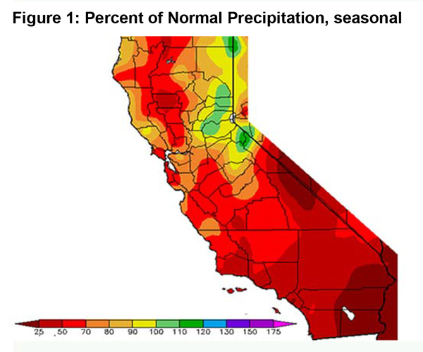
Seasonal precipitation will finish a bit above normal in the Sierras from Plumas County southward to Madera County (Figure 1, below). Much of the rest of the area will likely close out the rainy season with 50-70% of average rainfall. A few areas of Southern California – mainly south and east of Los Angeles County – will only record 25-35% of normal precipitation.
Temperatures during April were near to a bit above normal, but no prolonged heatwaves occurred. This is mainly due to the absence of offshore winds which haven’t really been a factor so far in 2018. Long term models out to the next two weeks indicate there will be few, if any periods of offshore winds. Local research also is indicative of fewer than average offshore wind events throughout the remainder of May.
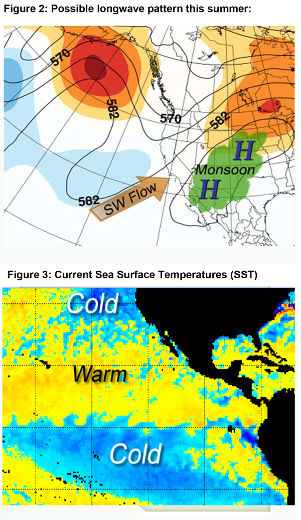
This summer’s monsoon may be more active than 2017’s. Last year’s monsoonal surge was weak and shifted well east of the area. This resulted in one of the least stormy summers in recent memory. This year, there may be significantly more subtropical moisture available in the Southwest, but longwave patterns may keep most of the moisture suppressed east of the Colorado River (Figure 2, below).
Sea surface temperatures (SST) are well below normal across the southeast Gulf of Alaska and the waters off the Pacific Northwest coast (Figure 3, below). This may allow a weak trough to linger to our north which may, in turn, keep the flow aloft oriented from southwest direction. This is generally unfavorable for the import of subtropical moisture into California. But due to the expectation of higher levels of precipitable water availability over the Southwest, there may be a few cycles of wet thunderstorms, particularly over the deserts.
Temperatures are expected to remain near to slightly above normal through the rest of spring and throughout the summer. Onshore flow may be a bit more prevalent this year which may keep conditions a little cooler than 2017, particularly near the coast.
Fuels and Drought Outlook
Live fuel moisture continues to linger above normal over much of the central part of the state due to timely rains. Seasonal grasses remain green at the current time along the central coast and lower elevations of the Sierra Foothills. But grasses in interior valleys of San Luis Obispo County are beginning to cure while western Kern and Kings County have seen curing complete for the season.
Southern California is more of a mixed bag. Grasses are still green and brush is still growing and flowering from western Los Angeles County north and westward. However, grasses over Orange County and much of San Diego as well as western Riverside and San Bernardino Counties are cured out or will cure shortly. Grass fire season will likely start soon in these dry areas of Southern California, but since the grass growth was quite limited in these areas, fire behavior may be moderate in the absence of offshore winds.
Further north, grass fire season may be more dramatic and longer lasting. After a slow start, a moderate to heavy grass crop is in place over much of Central California. Once these areas cure out from south to north, expect very active fire behavior during peak heating hours due to heavy fine fuel loading. This will be especially true over the Sierra Foothills where dead, bug-killed timber will be a problem for years to come.
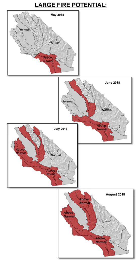
This year’s expectation of a more active monsoon season compared to last year may lead to a greater chance of wet thunderstorms in the high country. The lack of convection allowed fuel moisture values to drop to near record low readings in the Sierras in 2017. While a repeat is not likely this year, there may however be more lightning starts in higher, more remote country due to a lack of snow below 9,500 feet. Therefore expect these higher elevations to see large fire potential climb to above normal by the start of August. The rest of the area will see large fire potential climb to above normal outside the desert and the irrigated farmland of the San Joaquin Valley. Resource demand may spike in late May into early June over Central California before leveling off to above levels through the rest of the summer.
Source: Predictive Services
