


Statistics
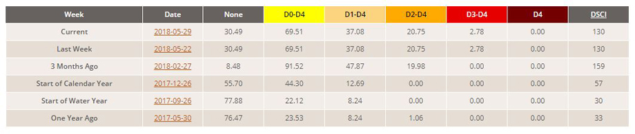
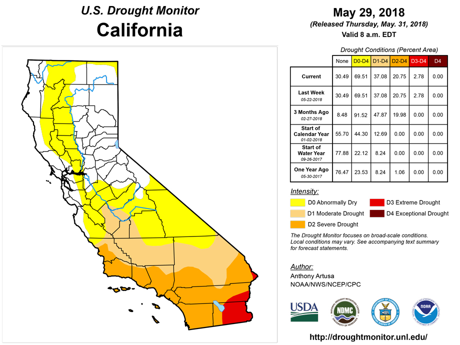
California and National Drought Summary for May 29, 2018
Summary
May 31, 2018 - Hot weather (daytime high temperatures in the 90's) stretched from Arizona eastward to Louisiana early in the drought week, before spreading rapidly northward over the Great Plains and much of the Mississippi Valley. Some locations reported triple-digit heat during the week, associated with an amplifying ridge in the middle troposphere over the central contiguous U.S. Though the observed weekly precipitation pattern was largely convective in nature, both AHPS and ACIS depict the heavier precipitation amounts (over an inch) generally across the Southeast, the central Gulf Coast area, and the northern and central High Plains. These areas of heavier rainfall were associated with Subtropical Storm Alberto and baroclinic activity. Alberto developed early in the drought week over the western Caribbean Sea and tracked north over the eastern Gulf of Mexico. By early Monday evening (May 28th, Memorial Day), the center of Alberto crossed the Florida panhandle near Panama City. Preliminary wind reports indicated 40 mph sustained winds at Panama City, with a gust to 59 mph. Near and along Alberto's path northward, rainfall amounts of 3-8 inches were generally received, with locally heavier amounts.
Northeast
No changes were made to the drought depiction this week. The southwest part of coastal Maine has been relatively dry during the past few weeks, with AHPS Departure from Normal Precipitation (DNP) values ranging from 3-4 inches below normal during the past 30 days. This area in particular will be reassessed next week for the possible introduction of abnormal dryness (D0).
Southeast
Heavy rain (generally 3-8 inches) associated with Subtropical Storm Alberto resulted in the removal of abnormal dryness across Florida, South Carolina, and nearly all of Georgia. In Alabama, moderate drought (D1) was removed, in addition to a significant amount of D0. The rainfall distribution pattern associated with the subtropical storm is quite asymmetrical, with a large portion of the rain falling west of the center.
South
Abnormal dryness was erased from southern Mississippi this week, thanks to Alberto's rains. In contrast, recent heat and dryness promoted the expansion of D0 across northwest Louisiana and western Arkansas. The 30-day ACIS SPI has values of -1 to -2 in general across the Arklatex region. A major overhaul of the drought depiction in Texas was rendered this week, with some areas showing improvement and others showing deterioration. Recent rain in parts of western Oklahoma favored small-scale improvements in the core drought region, while the lack of significant rain in parts of eastern Oklahoma warranted one-category deterioration.
Midwest
In north-central Minnesota, with streamflow indicators now closer to normal and with improved lake levels, moderate drought (D1) was removed. In western Missouri, where 2-4 inches of rain were reported this week, a one-category improvement was rendered to the depiction. In the northwest part of the state, a one-category deterioration (from D1 to D2) was made to the counties of DeKalb, Clinton, and Caldwell. Dryness and moderate drought across northern Missouri have resulted in a wide array of impacts. These include, but are not restricted to, the implementation of community water restrictions, very short hay carryover supplies from the recent long cold winter (and in some cases, the need to purchase hay in early spring to sustain livestock), and short pastures. Other concerns include low to very low pond levels, low subsoil moisture levels, and some reports of corn starting to roll up to protect itself from the heat and drought. In southwestern Indiana, acute (30-day) rainfall deficits, the 30-day SPI map, and weekly daytime temperatures in the 80's and low 90's reveal a rapid drying out of conditions. An area of abnormal dryness (D0) was therefore introduced to the depiction in this region, and the rapidity of this drying out warrants careful reassessment of conditions next week.
High Plains
In south-central and southeastern Nebraska, recent triple-digit heat and dryness has been an issue, especially for pastures and alfalfa. Where 90-day SPIs were less than -1.5, moderate drought (D1) was introduced. This included a small area south of Omaha, which was linked to the D1 area in nearby Iowa. Moderate drought (D1) was also expanded across northern Fillmore and northwest Saline counties. Incidentally, Omaha matched or set four days of high temperature records during the long Memorial Day weekend (Friday through Monday). The highs ranged between 97 and 101 degrees F. Across northwest Kansas, widespread heavy rain (3 inches or greater, with some isolated CoCoRaHS totals of about 9 inches) warranted a one-category improvement in the depiction. Next week, once the rainwater has a chance to either percolate into the soil or run off into streams, additional alteration of the Kansas depiction may be needed. Across the Dakotas, D0, D1, and D2 categorical areas were generally expanded in coverage, due mostly to recent precipitation deficits. There was one area of improvement (D0 was removed) in the Black Hills of South Dakota due to rainfall this past week.
West
Recent rain warranted a one-category improvement in drought conditions (D1 to D0) across northeast Montana, and the two areas of abnormal dryness in this region were consolidated into one. For now, despite recent heat and dryness, it was decided to hold off on introducing any D0 into extreme northwest Montana. Continuing snowmelt runoff and above average river and stream flows provide plenty of water in that area for irrigation. In addition, in nearby Idaho, some areas are coming out of their worst flooding in years. Bonner County continues to experience flooding, and farmers in adjacent Boundary County will be struggling with crop loss from the saturated soils in that region. In Colorado, some improvement in the drought depiction was made from approximately the Front Range just west of Denver eastward through Kit Carson and Cheyenne Counties near the Kansas border. Relatively small adjustments were made in New Mexico this week as well, especially in central and east-central portions of the state.
Alaska, Hawaii, and Puerto Rico
Much of Hawaii had a wet spring so far, especially northeast-facing, windward slopes. The leeward areas of some of the islands have started to dry out a bit. Accordingly, abnormal dryness (D0) was introduced to leeward portions of Oahu, Molokai, Maui, and the Big Island this week. No changes were made to either the Alaska or Puerto Rico depictions.
Looking Ahead
For the ensuing 5-day period (May 31-June 4, 2018), most predicted heavy rain areas (1.5-3.0 inches or greater) are expected to be east of the Mississippi River, where little dryness and drought currently exist. West of the Mississippi River, smaller-scale heavy rain areas of a convective nature are forecast over North Dakota, Nebraska, and southwestern Missouri. For the subsequent 5-day period (June 5-9, 2018), CPC predicts elevated odds of near to below normal precipitation for most of the Lower 48 states. Exceptions include in and around the Florida Panhandle, Minnesota and parts of adjacent states, and much of Arizona and New Mexico, where odds favor above normal precipitation.
Author(s):
Anthony Artusa, NOAA/NWS/NCEP/CPC
Dryness Categories
D0 Abnormally Dry—used for areas showing dryness but not yet in drought, or for areas recovering from drought.
Drought Intensity Categories
D1 Moderate Drought
D2 Severe Drought
D3 Extreme Drought
D4 Exceptional Drought
Drought or Dryness Types
S Short-Term, typically less than 6 months (e.g. agricultural, grasslands)
L Long-Term, typically greater than 6 months (e.g. hydrologic, ecologic)
National Drought Mitigation Center

