


Mariposa and Oakhurst could reach 97 degrees on Wednesday.
Mariposa and Oakhurst heat index in the range of Orange to Red on Wednesday.
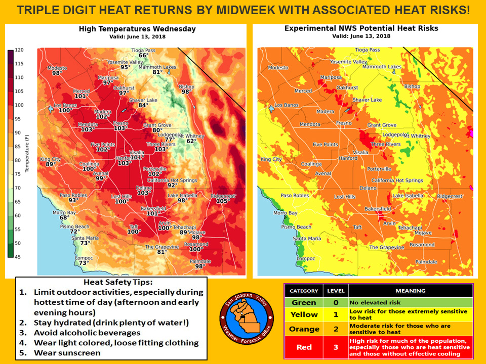
June 11, 2018 - The National Weather Service Hanford office reports a dramatic warm up during the next few days will bring high temperatures to the century mark throughout much of the San Joaquin Valley, lower foothills and the Kern County Desert.
Prolonged exposure to triple digit heat can pose a health risk to the elderly, persons with respiratory ailments and anyone who is not yet acclimated to hot weather.
If you’re going to be outdoors during the hottest time of the day (between 1 pm and 6 pm), avoid strenuous exercise, stay hydrated and wear light colored, loose fitting clothing.
  Area Forecast Discussion
  National Weather Service San Joaquin Valley - Hanford CA
  345 AM PDT Mon Jun 11 2018

  .SYNOPSIS...
  A ridge of high pressure building across California will bring
  warming temperatures for the next few days, with widespread
  triple digit highs expected by mid-week. Dry conditions will
  prevail throughout the forecast period with a cooling trend
  possible by the end of the week.

  &&

  .DISCUSSION...
  The trough of low pressure which brought gusty winds and highs
  around 15 degrees below climo across central CA continues to move
  away from the area, allowing a high pressure ridge to move into
  the region. This transiting ridge will bring a warming trend to
  our area for the next few days, with temperatures returning to
  around normal today and continuing to increase through Wednesday,
  when highs will be into the triple digits at most SJ Valley, lower
  foothill, and desert locations.

  The recent round of cooler than normal conditions will help to
  accentuate these increasing temperatures as much of our area
  outside the higher elevations climbs into moderate heat risk
  category for persons sensitive to the heat. People should avoid
  strenuous activity during the hottest part of the day and stay
  well hydrated during this period of increasing temperatures.

  Models are similar in moving another low pressure center inland
  near the Pac NW by Thursday and digging a trough into California
  through the end of the week as additional shortwave energy drops
  southward. There are some differences in the details of the
  developing trough but general agreement in swinging a closed low
  to near the Great Basin region by the start of next week.
  This will bring a return of cooler temperatures by the weekend,
  with highs dropping back a few degrees below climo. The forecast
  remains dry throughout the period, as moisture lifting northward
  with tropical system Bud is swept eastward by the developing
  trough later this week.
Source: NWS

