


Slightly above normal temperatures this summer into the fall – greatest departure across inland areas.
Slightly below normal number of summer thunderstorms outside the eastern deserts.
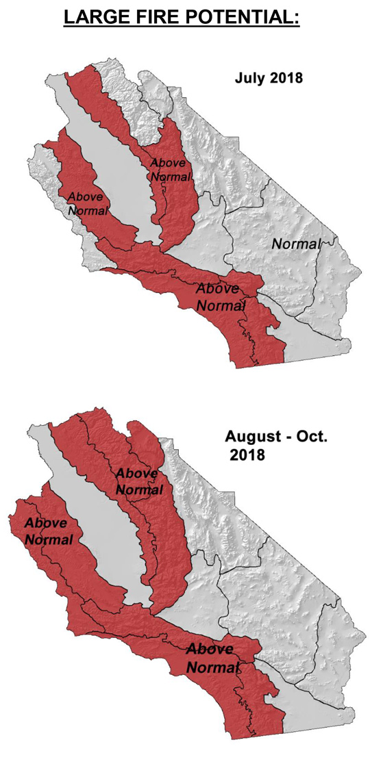
Above normal large fire potential spreading from south to north.
Greatest large fire potential in the Sierra Foothills.
Weather Discussion
July 2, 2018 - Frequent troughs from the Pacific Northwest visited the area during the past month. A prevalent onshore flow coupled with northwesterly flow aloft kept
 temperatures moderate for the most part in June with no extended periods of exceptionally hot/dry weather. There were a few 2-3 day runs of very warm temperatures, but the long-term, multi-week heatwaves of past Junes did not appear.
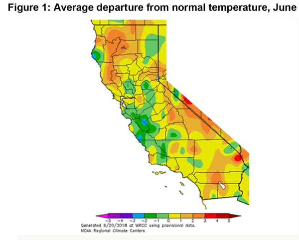
Temperatures remained within a couple degrees of normal with greater disparities occurring over Southern California (Figure 1, below). Precipitation did fall over portions of Northern California and the Great Basin, but most of it remained north of the area. Gusty onshore winds were recorded at the beginning of the month, but aside from some sundowner winds in Santa Barbara County, no offshore winds occurred last month.
Sea surface temperatures (SST) remain below normal across much of the eastern Gulf of Alaska and areas off the Pacific Northwest coast. But there has been some dissipation of the cooler than average waters the past couple of weeks and now most areas in the eastern Pacific have close to normal SST.
The dissipation or at least the weakening of SST anomalies over the Gulf of Alaska may result in less of a pervasive onshore pattern heading into the summer. The cold water in this area was a likely culprit as to why onshore flow was frequent this spring with relatively few periods of offshore flow. This pattern is expected to continue in July, but it may not be as pronounced as earlier this year.
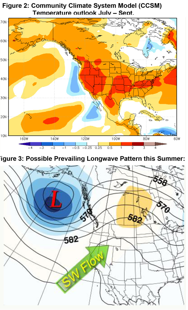
Most long term model guidance depict above to well above normal temperatures covering the western half of the country the next few months. The Community Climate System Model (CCSM, which uses 4 independently run models with a strong climatological component included) may best represent the weather this summer. While much of the West and Midwest may see above normal temperatures this summer, there is a “corridor” of closer to normal temperatures extending from New Mexico into Colorado which is the most likely axis of plentiful monsoonal moisture this year (Figure 2, top below). This summer’s Southwestern Monsoon may be more active than last year (which was extremely quiet in terms of thunderstorms), but most of the moisture may remain well east of the area due to a prevailing southwesterly flow aloft (Figure 3, below).
Despite this, there will likely be more convection this summer compared to last year in the Sierras. This may result in more initial attack in these areas, as well as the Sierra Foothills which saw few, if any, lightning starts in 2017. The only area which may see near to above normal convection this summer may be the far eastern deserts. The rest of the area should see below normal precipitation through October.
Fuels and Drought Outlook
Dead fuel moisture declined, more or less, in a steady pace last month. No prolonged hot and dry periods occurred which kept fuels from drying out all at once. This year’s slower decline in dead fuel moisture was not enough to compensate from a drier than normal winter as, at the current time, dead fuel moisture is below average over most areas. The driest fuels, in general, are located in Southern California south and east of Los Angeles County. Fuels in these areas have been close to record dry levels at times this spring which is more of a reflection of the dry winter than the moderate conditions of spring.
Live fuel moisture still is above critical readings at the current time. Unlike last year (and several other years since 2010), new starts have shown only moderate growth this spring in the absence of wind. Live fuels are showing some resistance to fire spread, but this advantage will erode in coming weeks. Live fuel moisture will likely mimic what has been seen in the dead fuels with critical conditions spreading from south to north in August. Most areas aside from the highest elevations of the Sierras will see all fuel types dry enough for active burning and high levels of consumption before Labor Day.
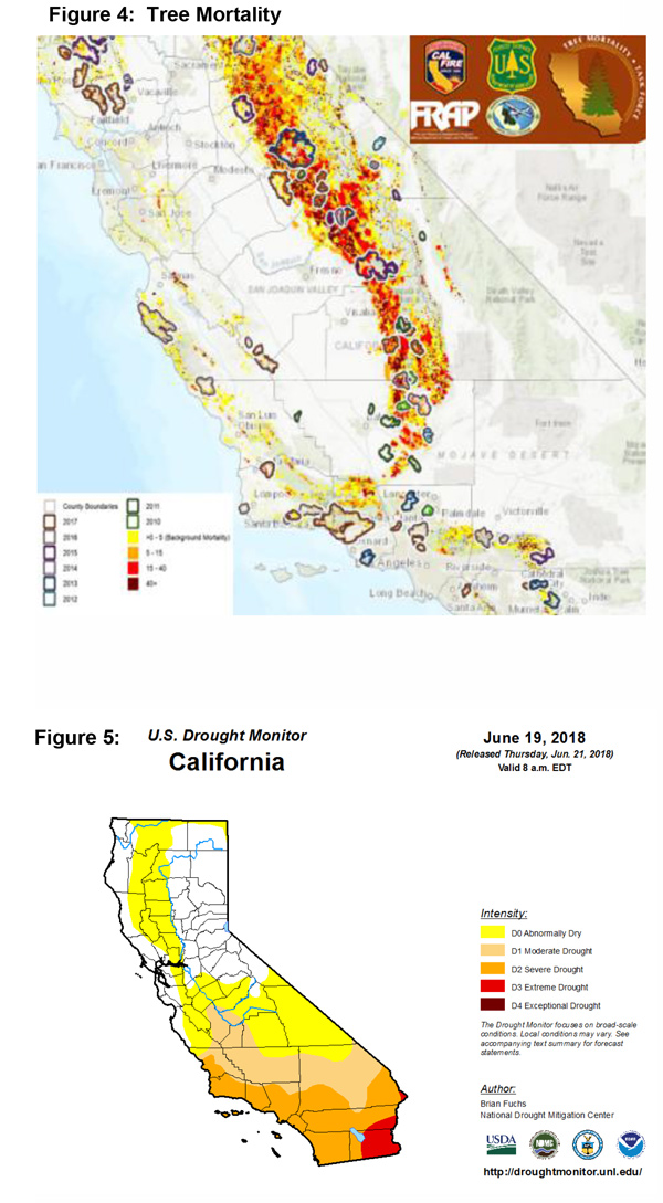
The area of greatest concern regarding large fire potential continues to be in the Sierra Foothills. A high amount of tree mortality exists there, from 2,000 – 7,000 feet, with some areas seeing well over 50% of overall heavy evergreen timber affected (Figure 4, below). The rate of tree mortality may slow down this year as the beetle infestation runs its course, but there will still be a vast expanse of trees with dead and dry needles which will readily burn during the hot summer months. There may be more convection in this area this summer, but storms in this region are more of a hindrance than help due to the fuel conditions. Any lightning strikes not accompanied by significant wetting rain have a good chance of generating new starts in the Sierras and other areas with a high amount of dead fuel loading. Expect the drought (Figure 5, below) to expand this summer into the fall as the majority of long range models as well as the CPC guidance paints a dry, hot scenario this fall.
Source: Predictive Services

