


Wednesday Public Information Map
CLICK HERE FOR A LARGE MAP (3,000 Pixels Wide and 2.0MB)

Click here for the Sierra Sun Times Scanner
Reminder: Scanner Information is NOT Official
Click here for Tuesday's Information on the Ferguson Fire
Update: 8:14 P.M. Yosemite National Park Superintendent Issues Stage 1 Fire Restrictions Until Further Notice Due to High Fire Danger
Update: 7:00 P.M. Ferguson Fire Near Yosemite National Park in Mariposa County Wednesday Evening, July 25, 2018 Update: 41,576 Acres with 26% Containment
Update: 5:55 P.M. Ferguson Fire Mandatory Evacuations Lifted for Jerseydale Road & Sweetwater Ridge Area on Wednesday, July 25, 2018
Update: 4:22 P.M. Ferguson Fire Community Meeting in Mariposa on Thursday, July 26, 2018
Update: 1:19 P.M. Spanish video added:
11:56 A.M. Sierra National Forest Morning Operational Update Video for the Ferguson Fire on July 25, 2018
Update: 10:13 A.M. Fire Advisement Issued for Highway 49 South from Stumpfield Mt. Road to the Mariposa/Madera County Line Due to the Ferguson Fire Near Yosemite National Park
Update: 9:30 A.M. The Red Cross has opened 2 additional shelters due to more Ferguson Fireevacuations located at Mountain Christian Center in Oakhurst and Mariposa Elementary School in Mariposa
Update: 9:23 A.M. Wednesday Morning Infrared Map of the Ferguson Fire in Mariposa County Near Yosemite National Park
Update: 8:17 A.M. Mandatory Evacuation Order for Ponderosa & Lushmeadows Subdivision and Additional Areas Due to the Ferguson Fire Near Yosemite National Park
Update: 6:38 A.M. On Wednesday, July 25th Mariposa County Air Pollution Control District Reports Ferguson Fire is Affecting Air Quality in the Area - Currently Some Locations are in the Hazardous Range
Update: 6:07 A.M. Update: 7:14 A.M. Ferguson Fire Near Yosemite National Park in Mariposa County Wednesday Morning, July 25, 2018 Update: 38,522 Acres with 25% Containment
Update: 5:07 A.M. Mandatory Evacuation Order for Vista Lago to Old Mill Road in Mariposa County Due to the Ferguson Fire Near Yosemite National Park
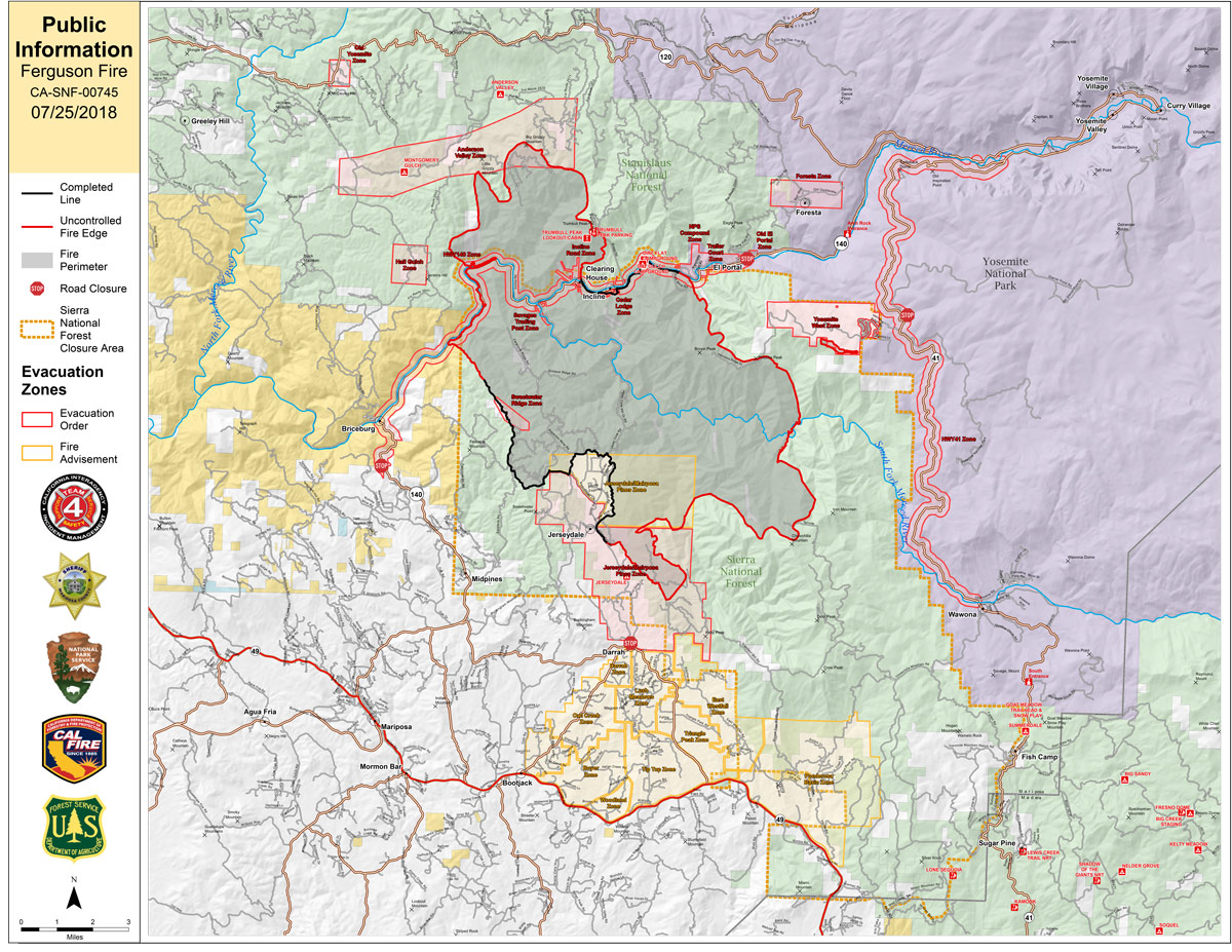
Update: 5:00 A.M. Ferguson Fire Near Yosemite National Park in Mariposa County Wednesday, July 25 Operations Map
July 25, 2018 - The Ferguson Fire is burning on the Sierra National Forest near Yosemite National Park in Mariposa County.
Today
Ferguson Fire Community Meeting in Greeley Hill on Wednesday, July 25, 2018
Tuesday Evening Information
Ferguson Fire Mandatory Evacuations Lifted for Mariposa Pines Area on Tuesday, July 24, 2018
July 24, 2018 - Awahanee, CA. - The Ferguson Fire was relatively calm throughout much of the area Tuesday. A heavy inversion layer kept fire activity to a minimum. The fire grew 1,693 acres to a total of 37,795 acres at 26 percent containment. North of the Merced River on the Stanislaus National Forest, firefighters constructed indirect containment lines up Soapstone Ridge, opening old roads near the burn scar of the 2013 Rim Fire. Crews strengthened and improved containment lines east toward Eagle Peak and down to El Portal.
Along the eastern edge of the fire, crews were successful initiating strategic firing operations to remove unburned vegetation between containment lines and the fire. Crews also evaluated structures for defensible space.
South of the Merced River on the Sierra National Forest, containment lines were secured from Jerseydale across to Wawona Campground. Crews will continue planning strategic firing operations to help build a wider buffer to stop the fire’s spread.
Yosemite National Park closure: Yosemite National Park officials announced closures to the Yosemite Valley and Wawona areas, as well as the Mariposa Grove of Giant Sequoias, effective noon on Wednesday, July 25. With the ongoing closure of Highway140, visitors can exit the park using Highways 120 and 41. For information on Yosemite National Park, go to: nps.gov/yose or call 209-372-0200.
Repopulation: Mariposa County law enforcement began incremental repopulation of the Jerseydale and Mariposa Pines communities this evening.

