


Statistics
California and National Drought Summary for July 24, 2018
Summary
July 27, 2018 - During the period covering July 17-24, precipitation fell across a vast majority of the East, the heaviest of which flooded parts of Maryland, including the Washington D.C. area. Heavy rains also fell in parts of Florida, Kentucky and South Carolina. In the central U.S., moderate precipitation fell in parts of the High Plains while lighter rains provided little to no relief in parts of Kansas. The drought-stricken areas of Oklahoma and Texas saw little to no precipitation and triple digit temperatures, exacerbating drought conditions.
Northeast
Tropical moisture flowed in from the Atlantic, providing abundant moisture for a large area covering Maryland, central Pennsylvania, southern New York, and parts of New England. Washington Dulles International Airport broke its July daily precipitation record with 5.01 inches of rain on the 21st. The previous record was 3.71 inches set on July 11, 2013. Radar estimates for the 7-day period were as high as 10-12 inches in Maryland. Since the beginning of June the Baltimore-Washington International Airport has received nearly 18 inches of rain, surpassing 1889 for its wettest June/July total on record. Abnormal dryness was removed in Virginia and Maryland but remained in Delaware and southern New Jersey where lighter precipitation fell. Moderate drought (D1) was removed in Massachusetts where streamflows have rebounded. In contrast, moderate drought was expanded in upstate New York where 30-day precipitation deficits exist. Abnormal dryness was extended out through northern New York.
Southeast
Tropical moisture flowed in from the Atlantic, providing abundant moisture for much of the mid-Atlantic region resulting in generally above normal precipitation for much of the region during the USDM period. Some locations in coastal South Carolina and north central Florida received between 8 and 9 inches during the 7-day period. Much of Georgia and the western Carolinas received 1-3 inches from summertime convection.. Precipitation totals in northeast Virginia approached 10 inches. Abnormal dryness continued for some of the central Carolinas; however, it was contracted in areas where this week’s heaviest precipitation fell.
Midwest
The Midwest experienced a mixture of both above- and below-normal precipitation amounts during the USDM week. In eastern Kentucky and Tennessee and along the border of Ohio and Indiana, precipitation amounts were the highest. As much as 5 inches of rain fell in those areas. Farther west, dryness prevailed. Little to no rain was measured across much of Illinois, eastern Missouri and western Iowa. Precipitation totals in those areas were 25-50 percent below normal for the 30-day period. The USDA reported that topsoil conditions were 77 percent short to very short in Missouri while subsoil conditions were 72 percent short to very short. Farmers in Missouri are having to bail the corn crops since little to no ear development is widespread. In Michigan, topsoil was rated at 68 percent short to very short and subsoil conditions were 72 percent short to very short. Local reports indicated that soybeans in parts of Michigan were less than 2 feet high and the leaves were flipped and showing their undersides. USDA reported that soybean conditions were 20 percent poor to very poor across the entire state. D0 drought was expanded to cover most of Lower Michigan and D1 was expanded slightly in eastern Michigan and introduced in southern Michigan. Abnormal dryness was also introduced in central Wisconsin and southeast Illinois, and expanded in parts of northern Minnesota.
South
Across much of the South, no measureable rains fell during the period. This was especially true for Texas, Oklahoma, and Louisiana. Arkansas, Mississippi and Tennessee received moderate precipitation – generally less than 2 inches, although eastern Tennessee had locally higher amounts of 3-5 inches during the period. Departures during the last 30- and 60-days were generally about 10-25 percent below normal. One of the driest parts of the region was around the borders of Arkansas, Louisiana, Oklahoma, and Texas where two separate areas of extreme drought (D3) were introduced this week. Extreme drought was also introduced in a small area to the west of Dallas, Texas. The drought has been exacerbated by extreme heat. Many locations in Texas have had two straight weeks of maximum temperatures reaching 100 degrees F or more. On July 23, Waco, Texas recorded an all-time high temperature of 114 degrees F. The heat also stretched into Louisiana where, on the 22nd, Shreveport hit 108 degrees F, besting its monthly record. Conditions in some parts of Texas are being compared to the drought of 2010 and 2011. One rancher reported that he had only had 6 inches of rain since January and another reported just 4.5 inches. The persistent heat and dryness has browned grasses, dried up stock tanks and ponds and increased fire danger.
High Plains
Precipitation across this region was scattered during the USDM week. The heaviest amount, generally in the range of 2-4 inches, fell in the eastern Dakotas and parts of Nebraska. Short- and long-term effects of drought/dryness remain along the Canadian/North Dakota border and northeast South Dakota. Recent rains in South Dakota contracted drought along the southern portion of the depiction, but expanded the abnormal dryness (D0) in the western part. Abnormal dryness was introduced in south central South Dakota. In Nebraska, drought/dryness began to creep back into the southeast part of the state where 30-day precipitation departures were apparent. Drought/dryness worsened in Kansas during the period, especially in the eastern half of the state where precipitation deficits have grown. Year-to-date precipitation percent of normal values were 25-50 percent across parts of east central Kansas. Exceptional drought (D4) was slightly expanded in this area and the two areas of extreme drought (D3) were connected. Drought conditions remained unchanged for the most part In Colorado. The lone exception was a slight contraction of exceptional drought in the southeast where heavy rains recently fell. Severe drought was expanded slightly in the north central part of Colorado.
West
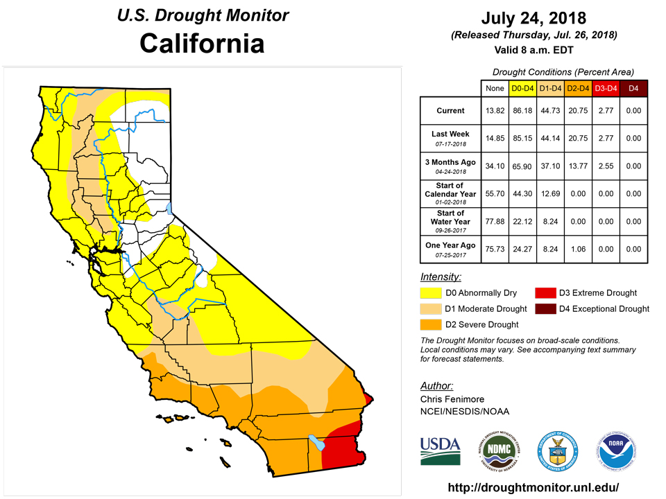
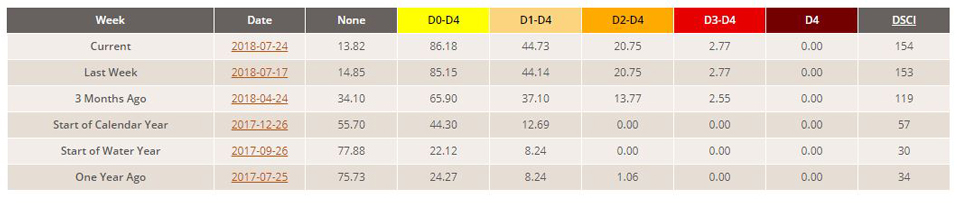
Drought remained entrenched in the Four Corners region but, as the monsoon season begins to ramp up, there is hope that improvement is on the way. In fact, 30-day surpluses of 2-3 inches were common near and west of Flagstaff. Year-to-date precipitation totals were now reaching the positive side. It was reported that the Eastern Rim and the White Mountains have also seen very beneficial rains. As a result of the robust start of the monsoon season, there was some contraction of D3 and D4 in Arizona. In the Pacific Northwest, dryness in Oregon prompted the expansion of D2 across the Cascades and into the Willamette Valley. In California, persistent heat and dryness increased fire danger. As of July 24, it was reported that the Ferguson fire had burned 57 square miles in Yosemite, but was only 25 percent contained. Yosemite Park was closed for the first time in 28 years due to the fire hazard there.
Alaska, Hawaii, and Puerto Rico
It was reported that some of the leeward areas continue to be drier than normal across the main Hawaiian Islands. Vegetation is beginning to dry out in those areas which prompted west Oahu to go from D0 to D1. In Alaska, it was reported that 60-day rainfall deficits are becoming more noticeable in parts of the central and eastern Interior Alaska. There have been record high temperatures (80’s- to 90’s) along with dew points in the 40’s and 50’s. As a result of this, the wildfire season is coming to life. This area will be re-examined next week.
No changes were made for Alaska or Puerto Rico this week.
Looking Ahead
During the next 5 days, moderate precipitation (2-4 inches) is forecasted to fall in parts of the drought stricken areas of the Midwest and High Plains. The heaviest of these rains is projected to fall in southwest Missouri and eastern Kansas and Oklahoma. The front range of Colorado is also expected to receive 2-4 inches of rain. Elsewhere, lighter precipitation (1-2 inches) is expected to fall in the Northeast, Coastal Carolina’s and south Florida. Temperatures are forecasted to be cooler-than-normal for much of the High Plains and Midwest during the next week. Above normal temperatures are projected for much of the West and East. The 6-10 day outlook from the Climate Prediction Center calls for an increased chance of below-normal precipitation in the drought stricken areas of Missouri as well part of the High Plains and Northwest. The probability of above-normal temperatures are highest in the Southwest and Northeast while the probability of below-normal temperatures are the highest in the Southeast.
Author(s):
Chris Fenimore, NOAA/NESDIS/NCEI
Dryness Categories
D0 Abnormally Dry—used for areas showing dryness but not yet in drought, or for areas recovering from drought.
Drought Intensity Categories
D1 Moderate Drought
D2 Severe Drought
D3 Extreme Drought
D4 Exceptional Drought
Drought or Dryness Types
S Short-Term, typically less than 6 months (e.g. agricultural, grasslands)
L Long-Term, typically greater than 6 months (e.g. hydrologic, ecologic)
National Drought Mitigation Center

