


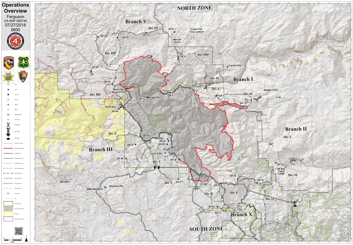
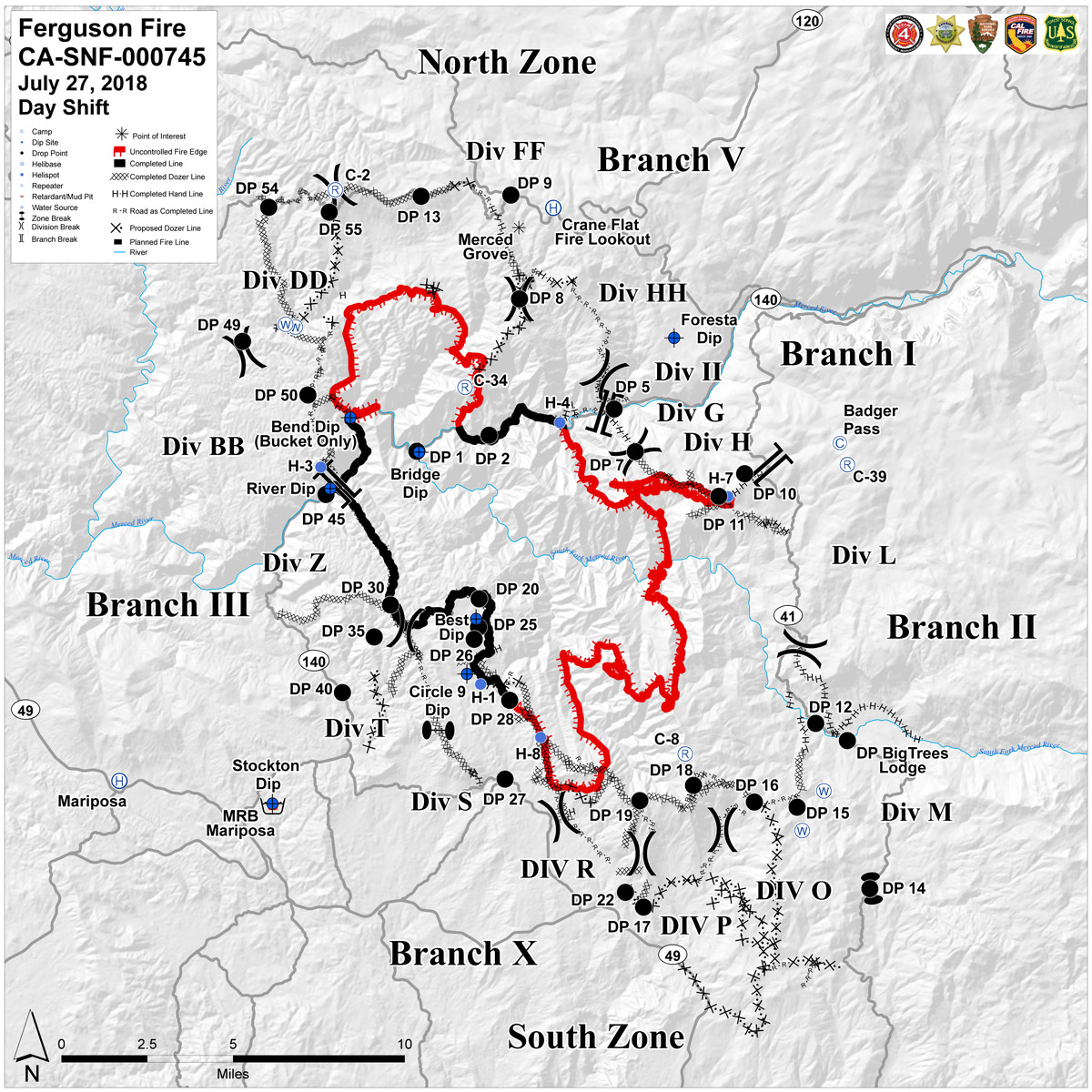
Friday Operations Map
CLICK HERE FOR A LARGE MAP (3,000 Pixels Wide and 3MB)
CLICK HERE FOR A LARGE MAP (3,000 Pixels Wide and 2MB)
July 27, 2018 - Friday Operations Map of the Ferguson Fire in Mariposa County near Yosemite National Park.
Thursday Evening Information
July 26, 2018 - Firefighters took advantage of calm winds and hazy skies from a persistent inversion layer to widen containment lines through tactical firing operations. The Ferguson Fire grew 924 acres throughout the day to a total of 44,223 acres as of 6:00 p.m. Containment is at 27 percent.
Firefighters burned vegetation from containment lines back toward the fire to expand buffers around the communities of Yosemite West and El Portal along the fire’s northeast perimeter. Meanwhile, favorable conditions and light winds out of the southwest helped firefighters redirect uncontained fire back toward the southern perimeter’s containment lines. Crews also patrolled containment lines and laid hoses around the community of Wanona southeast of the fire.
Along the north perimeter of the fire, bulldozers and firefighters worked on completing open sections of containment line from Montgomery Ridge east to Pilot Peak and down to Eagle Creek. Crews continue exploring terrain closer to the fire’s edge for opportunities to take a direct attack on the fire.
Containment lines along the western perimeter were holding well. A three-acre spot fire crossed over the containment line outside of Jerseydale, but crews were able to quickly suppress it.
Yosemite National Park closure: Yosemite National Park officials enacted closures Wednesday for the Yosemite Valley and Wawona areas, as well as the Mariposa Grove of Giant Sequoias. For information on Yosemite National Park, go to: nps.gov/yose or call 209-372-0200.
Community Meetings: Representatives from the U.S. Forest Service, CAL FIRE and Mariposa County Sheriff’s Office met with residents during a community meeting at 6 p.m. today at the Mariposa Fairgrounds. They discussed the latest fire conditions and containment efforts.
The next community meeting is scheduled for 6:00 p.m. Friday, July 27, at Tenaya Elementary School in Groveland.
Mandatory Evacuations: Areas that are currently under a mandatory evacuation include:
- Anderson Valley
- Cedar Lodge/Indian Flat Campground
- East Westfall Road to Chowchilla Mountain Road, and all side roads
- El Portal Trailer Court
- Foresta
- Incline Road from Foresta Bridge to the last BLM campground
- Lushmeadows Community
- Old El Portal
- Old Yosemite Road
- Ponderosa Basin Community
- Rancheria Flat – Government Housing
- Savage’s Trading Post
- Tip Top Road from Triangle Road to Gunther Road, including Gunther Road
- Triangle Road from Darrah Road in the Lushmeadows area to Highway 49 South, and all side roads
- Yosemite View Lodge
- Yosemite West
Advisory Evacuations: This is NOT an Evacuation Order. This is an advisement only of a potential Evacuation Order should conditions change.
- Darrah Road from Triangle Road to Sherrod Road
- East side of Highway 49 South from Darrah Road to Triangle Road. This includes Boyer Road, Woodland Area, Wass Road and Tip Top Road.
- Mariposa Pines/Jerseydale Road
- Highway 49 South from Stumpfield Mountain Road to the Mariposa-Madera County Line, including Kemble Road, Stumpfield Mountain Road and Watt Road
- Triangle Road from Jerseydale Road to Highway 49 South, including all side roads.
- Sweetwater Ridge
Road Closures:Highway 140 is closed from the entrance of Yosemite National Park to 1.5 miles east of Midpines. Incline Road, River Road from Briceburg to the gate at Railroad Flat and all Campground areas along Highway 140 closed. Hites Cove/Jerseydale Road, Foresta Road, Anderson Valley Road, Summit Road and Old Yosemite Road.
Triangle Road from Darrah Road to Highway 49 South; East Westfall Road.
Chowchilla Mountain Road at Highway 49 South, Harris Road at Highway 49 South, Tip Top Road from Triangle Road to Gunther Road, all roads inside the Lushmeadows subdivision, and all roads inside the Ponderosa Basin subdivision.
Wawona Road (Highway 41) between Chilnualna Falls Road in Wawona and Bridalveil Falls Road in Yosemite Valley.
Red Cross Shelters:
- Mariposa Elementary School, 5044 Jones St., Mariposa, CA 95338
Animal Shelters:
- Small animals:Mariposa Elementary School, 5044 Jones St., Mariposa, CA 95338
- Large animals:5007 Fairgrounds Road, Mariposa, CA 95338

