 Ferguson Fire - Photo by J Bartlett Team Rubicon/BLM for USFS
Engines: 203 Water Tenders: 43 Helicopters: 14 Crews: 95 Dozers: 62 Total Personnel: 3,558
July 31, 2018 - Firefighters made progress toward full suppression on the Ferguson Fire. Officials reported the fire grew by 228 acres throughout the day and was at 58,074 acres as of 6 p.m. Containment is at 33 percent.
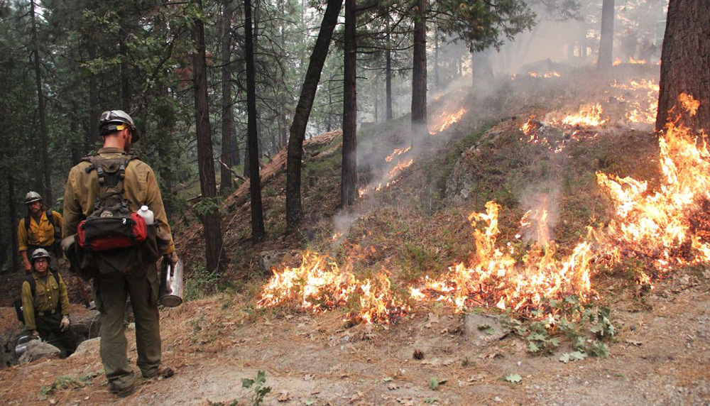
Firefighters prepared for nighttime tactical firing south along Wawona Road (Highway 41) toward Wawona Campground. Crews along the southern perimeter widened containment lines by up to 1,000 feet in some areas near Chowchilla Mountain Road using firing operations. The line should be wide enough to contain the spot fires that have occurred in the area in recent days.
Firefighters began constructing indirect fire lines to intercept a spot fire that had jumped containment lines a few days earlier south of El Portal. Crews performed tactical burning along a road south of the fire in response to the fire’s southeasterly movement. Additional personnel have been sent to the Foresta area in case the fire shifts to a more northeastern direction. Steep and inaccessible terrain have made direct attack on the fire difficult.
On the north end of the fire, crews will conduct nighttime burning operations northbound to Yosemite’s Merced Grove of giant sequoias and along the Thirteen Road toward Pilot Peak.
Area residents can expect to see increased smoke during the next few days as firing operations continue. Tactical firing is an effective way to reduce fuel loads while simultaneously buffering containment lines. It can reduce the duration and intensity of wildfires, particularly by decreasing available fuels and weakening the fire as it approaches containment lines.
Air quality is likely to decrease as a result of increased smoke from the firing operations. Residents can monitor the latest air quality and health advisories at:
· https://wildlandfiresmoke.net/outlooks/YosemiteArea
· https://wildlandfiresmoke.net/outlooks/SouthernSierra
Natural resource specialists have begun surveying the western side of the fire today to assess areas requiring repair and mitigation. Firefighters, in conjunction with resource advisors, play an important role in helping the landscape recover from containment lines and other suppression tactics.
Stanislaus National Forest closure: Stanislaus National Forest officials closed several roads and trails on the Groveland Ranger District within the vicinity of the Ferguson Fire. The closure order spans from Ferguson Ridge in the south to Pilot Ridge in the north. The closure is expected to be in effect until Sept. 30.
Yosemite National Park closure: Yosemite National Park officials today extended closures of Yosemite Valley, Wawona Road, the Mariposa Grove of Giant Sequoias, the Merced Grove of Giant Sequoias, Hetch Hetchy and other areas through August 5, conditions permitting. For more information, go to nps.gov/yose or call 209-372-0200.
Mandatory Evacuations: Areas that are currently under a mandatory evacuation include:
· Anderson Valley
· El Portal Trailer Court
· Foresta
· Old El Portal
· Old Yosemite Road
· River Road from Briceburg to the last BLM campground
· Yosemite View Lodge
· Yosemite West
Advisory Evacuations: This is NOT an Evacuation Order. This is an advisement only of a potential Evacuation Order should conditions change.
· Cedar Lodge/Indian Flat Campground
· Rancheria Flat – Government Housing
· Savage’s Trading Post
Road Closures:
· Anderson Valley Road
· Foresta Road
· River Road from Briceburg to the gate at Railroad Flat and all campground areas along Highway 140
· Summit Road
· Old Yosemite Road
· Wawona Road (Highway 41) between Chilnualna Falls Road in Wawona and Bridalveil Falls Road in Yosemite Valley
Incline Road and Highway 140 from the entrance of Yosemite National Park to 1.5 miles east of Midpines are closed to everyone except residents.
Red Cross Shelters:
· Mariposa Elementary School, 5044 Jones St., Mariposa, CA 95338
Animal Shelters:
· Small animals: Mariposa Elementary School, 5044 Jones St., Mariposa, CA 95338
· Large animals: 5007 Fairgrounds Road, Mariposa, CA 95338