


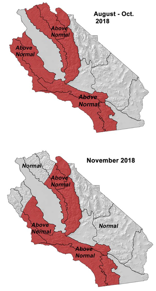
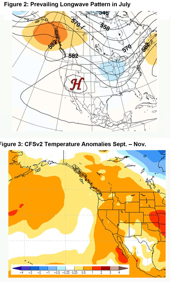
Above normal temperatures this summer into the fall – greatest departure across inland areas.
Near to slightly below normal number of summer thunderstorms outside the eastern deserts.
Above normal large fire potential most areas, slowly decreasing from north to south in the fall.
Greatest large fire potential in the Sierra Foothills.
Weather Discussion
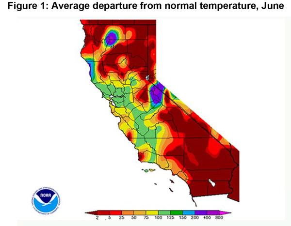
August 2, 2018 - A record breaking heatwave quickly developed across region during the 6th and 7th of July. A strong ridge along with an out-of-season offshore wind allowed temperatures to surpass all-time records over several areas. Temperatures
 were close to 30 degrees above normal in areas more accustomed to cooler weather such as Fullerton and UCLA where the high temperatures topped 110 degrees. This heat was accompanied by northeast and east winds of 20-35 mph, making for extreme fire weather conditions. Fortunately, the heat wave was of short duration – 72 hours or less in most places – and temperatures returned to near normal readings by the 10th.
The Southwestern Monsoon reached the state during the second week of the month, which kept Southern California hot and humid during the remainder of July. A few areas in the Sierras and the San Bernardino Mountains received over an inch of rain, but most areas didn’t receive significant precipitation outside of some heavy rains near Alpine County (Figure 1, below).
Sea surface temperatures (SST) remain strongly below normal off the Pacific Northwest coast. However, the Gulf of Alaska, in particular, has seen warming this past month. This may be due to the absence of storms in this area, but the next two weeks appears stormy in this area which may flip SST’s back to near average in the Gulf. But the cold waters off Washington and British Columbia may maintain their integrity over the next few weeks which may keep Pacific NW troughs more frequent to close out the summer.
While these troughs will be too far north to directly impact the area, they may grant a reprieve from the hot weather during the first half of August, especially over Central California. The expansive ridge of the past month (Figure 2, below) may be less of a factor in August. Temperatures are still likely to remain above normal through the outlook period, but heat waves may be less intense and of shorter duration than this past June (Figure 3, below). (Several stations may have set their all-time record warmest monthly records last month.)
Southwesterly flow aloft may also keep convection more limited in the Sierras. But the monsoon should remain active this year given the warm SST’s off the coast of Mexico, and a periodic bought or two of high humidity and wet thunderstorms over the southern part of the state in August into early September. But as a districtwide average, precipitation will average a little below normal, especially over Central California, through the rest of the summer.
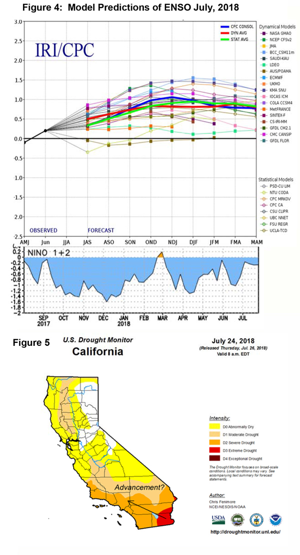
Concerning the onset of the winter “rainy season,” most longterm model guidance keep a weakly positive ENSO signal in place through the fall and early winter (Figure 4, bottom of page). The ENSO signal was weakly negative last winter, so SST’s across the El Niño Region 3+4 may be up to 1.5° C warmer than last year. That may equate to more precipitation this winter than last year with an earlier onset of significant wetting rains this year. But some caution must be exercised in reading too much into these numbers for last time a weakly negative ENSO trended into a weakly during this time of year, the Los Angeles Civic Center recorded their lowest seasonal precipitation total ever of 3.21” during the winter of 2006-2007.
Seasonal offshore wind events are expected develop close to their usual time in mid to late September. Currently, there is no clear signal as to whether this fall will be near normal in terms of number of offshore wind event or severity of the offshore winds. But the lack of a La Niña does lend a bit confidence that the offshore events may not be above normal again this year.
Fuels and Drought Outlook
After a fairly steady drop in dead fuel moisture (DFM) in the spring, the hot weather the past few weeks caused DFM to plunge to near record low readings over most predictive service areas. The dry dead fuels are uniform in areal coverage as there are very few areas in the Geographic Area where dead fuel moisture isn’t at the 5 percentile, or worse. Live fuels are now running a few weeks ahead in terms of seasonal drying and critical dryness levels are expected to be reached by the end of August.
The Skyline Fire near Corona may have offered a preview of burning conditions this fall. The fire developed in the mid-afternoon hours and spread quickly westward despite a moderate sea breeze from the west and humid conditions. This area was one of the driest this past winter and live fuel moisture may already be critically dry in this area as well as in much of Orange County at the current time. Live fuels will likely become critically dry over the rest of Southern California in a few weeks which will cause fires to spread rapidly through all fuel types, even during conditions not normally associated with large fire growth as was the weather during the Skyline Fire.
Large fire potential is expected to remain above average across most non-desert, non-irrigated areas through the fall due to exceedingly dry live and dead fuels. Expect fires to grow rapidly and show near total consumption during moderate fire weather conditions. During hot or windy periods, extreme fire behavior can be expected. Ignition components will be high and a rapid transition from fine fuels to heavier fuels will be possible during peak heating hours. The large fire potential will continue to be highest in the Sierra Foothills due to the presence of a moderate to heavy cured grass crop interspersed with a high amount of dead fuel loading. Heavy resource demand and a high resistance to suppression efforts will be possible in this area until seasonal rains arrive this fall. Look for large fire potential to drop to near average from north to south late this fall into the early stages of winter.
Source: Predictive Services
