


Statistics
California and National Drought Summary for July 31, 2018
Summary
August 2, 2018 - Early in the drought week, moderate precipitation fell along the East Coast with the heaviest rains falling in the eastern Carolinas and central Pennsylvania. Much-needed rains fell in a swath of area covering eastern Wyoming, much of Nebraska, Kansas and Oklahoma, eastern Colorado and the majority of New Mexico. The northern Plains, Midwest and South saw lighter precipitation amounts. Central and south Texas saw little to no precipitation during the week while the dry pattern continued for much of the West. For the month of July, preliminary statewide temperature data suggest much of the U.S. was warmer than average. The West, Southwest, South, and Northeast were among the warmest third of historical records which date back 124 years. Total precipitation amounts for the month of July were below average for much of the Midwest and Northwest. Also during the month of July, above average precipitation fell in the Mid-Atlantic States to Northeast, Southwest and parts of the High Plains.
Northeast
Heavy precipitation (5-10 inches) fell in northern Maryland and central Pennsylvania during the week. According to preliminary data, for the month of July, Pennsylvania’s total precipitation ranked as one of the top 5 wettest on record. Also based on preliminary data, it was one of their wettest January-July periods based on data going back 124 years. Elsewhere, moderate to heavy precipitation (1-5 inches) fell with the exception of eastern Maine, northern Vermont, eastern Massachusetts, and southern New Jersey where little to no measurable precipitation was recorded. Precipitation during the last 30 days was 300 percent of normal in eastern Pennsylvania and Maryland. Precipitation deficits in eastern Maine during the last few months prompted the expansion of D0. However, D0 was contracted in the southern half of New York and eastward through Connecticut and Massachusetts. The Cape Cod area has missed out on some the recent rains prompting the introduction of D0.
Southeast
Heavy precipitation (5-10 inches) fell for another week along the Carolina Coast. The 14-day totals approach 15 inches in some locations. However, persistent dryness continued in the central Carolinas where precipitation deficits were 1-3 inches below normal during the last 30-days. Summer-time convection in Alabama has been limited the past 30 days, allowing for deficits to approach five inches in the central part of the state. As a result, D0 was introduced in that region and parts of eastern Alabama.
South
Much-needed precipitation fell across most of Oklahoma and west central Arkansas, prompting the contraction of drought in some locations. Anywhere from a half inch to nearly 3 inches fell mostly north of I-40 in Oklahoma and south of I-40 in Arkansas. There was a precipitation surplus in parts of western Oklahoma stretching into north Texas, prompting the further contraction of drought and abnormal dryness there as well as in the central part of Oklahoma. In northeast Oklahoma, abundant precipitation the past 30 days prompted the removal of D3. Drought/dryness continued for much of Texas. Precipitation departures mounted, with precipitation approaching 10 percent of normal at the 30-, 60-, and 90-day time periods in much of south and east Texas. Exceptional drought was added to some locations in the south central part of the state where the dryness is the worse as well as in north central Texas along the Oklahoma border. Moderate to severe drought was contracted in southwest Arkansas where moderate rains fell.
Midwest
Generally, precipitation was below normal for much of the Midwest during the week. The only areas that received above-normal rains were eastern Missouri, central Illinois and western Indiana. There, a swath of light rains (one to three quarters of an inch) fell. However, the rains were only enough to contract drought in western Illinois. Elsewhere, D0 and D1 was expanded to cover the rapidly deteriorating conditions which were mostly concentrated in Missouri but also in southern Iowa and the southern tip of Illinois. Abnormal dryness remained in Wisconsin where 30-day precipitation was generally 25-50 percent of normal in some places. Average streamflows during the last 28 days in southeast Michigan were running at the 10-30 percentile level. Moderate drought was expanded in Michigan and parts of northern Ohio.
High Plains
A swath of light to moderate precipitation fell in an area roughly covering north and east Wyoming, east Colorado and much of Nebraska and Kansas. The heaviest precipitation fell in western Nebraska, Kansas and eastern Colorado where amounts of 2 inches were widespread. Despite the rains, long-term drought was hardly effected. There was a slight improvement in southeast Colorado, and D1 was removed in southwest Kansas where short term indicators have rebounded. Despite the monsoon season ramping up, dryness continued in west central Colorado where D3 was expanded. Moderate drought was expanded in southwest Wyoming where it remained dry during the period. There was also a slight expansion of D0 and D1 in North Dakota while D0 was contracted in southeast North Dakota into northeast South Dakota.
West
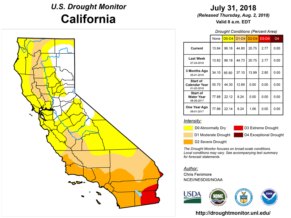
A swath of light to moderate precipitation fell in an area roughly covering north and east Wyoming and east Colorado. Monsoon rains continued to provide drought relief for some areas of the Southwest. Southern New Mexico saw the greatest improvements as drought was roughly reduced by 1-category in many areas. The heaviest rains have yet to reach east central New Mexico where extreme drought was expanded. The Northwest remains dry as precipitation during the past 6 months was 50-75 percent of normal across much of the region. Wetness prevailed in much of southern Montana. Abnormal dryness (D0) was expanded in Idaho where short-term deficits exist. Based on preliminary data, July ranked as one of the ten driest July’s on record in Idaho. The dry season continued in California and typically no changes are made there this time of year. However, some indices were showing greater drought than what is currently depicted. If negative impacts start to come in, then perhaps degradations would be needed. Wildfires continue to burn in the West. Of those, the Goose Creek fire in Nevada has burned more than 120,000 acres and the Carr Fire, outside of Redding, California, has burned more than 110,000 acres.
Alaska, Hawaii, and Puerto Rico
The combination of above-normal precipitation in the Kanai Peninsula of Alaska during the past 60 days and mountain snowmelt have brought the streamflows back up close to normal in the region. This prompted the removal of D0 in the peninsula. Below-normal precipitation at the 30- and 60-day time period was prevalent in the Fairbanks area, but the introduction of D0 in the area was held off another week. For the month of July, the entire state was warmer than normal, especially in southeast Alaska. The National Weather Service reported unusual dryness in the Panhandle where Ketchikan had the third driest July and Haines fourth driest.
Below-normal streamflows in addition to field reports prompted a small expansion of D0 across central Puerto Rico this week.
No changes were made in Hawaii.
Looking Ahead
During the next five days, moderate to heavy precipitation is projected to fall along the East Coast with amounts generally totaling up to five inches. The heaviest rains are forecasted to fall in the Southern Appalachians and the Panhandle of Florida. Much of the South is forecasted to remain dry during the next five days but average temperatures are expected to remain near normal. Temperatures could be as much as 10-20 degrees F below normal for parts of the Midwest early in the period along with 1-2 inches of precipitation. Temperatures in this area are expected to rebound later in the period. The Southwest Monsoon is expected to continue, producing beneficial rains for New Mexico and parts of Arizona. The Climate Prediction Center expects the greatest odds of above normal temperatures in the Southern Rockies stretching into the High Plains and in the Northeast during the next 6-10 days. The greatest probability of below normal precipitation during this period is centered in the High Plains.
Author(s):
Chris Fenimore, NOAA/NESDIS/NCEI
Dryness Categories
D0 Abnormally Dry—used for areas showing dryness but not yet in drought, or for areas recovering from drought.
Drought Intensity Categories
D1 Moderate Drought
D2 Severe Drought
D3 Extreme Drought
D4 Exceptional Drought
Drought or Dryness Types
S Short-Term, typically less than 6 months (e.g. agricultural, grasslands)
L Long-Term, typically greater than 6 months (e.g. hydrologic, ecologic)
Source: National Drought Mitigation Center

