 Greyback Forestry - Photo credit: Forest Service photo by Jim Bartlett
Engines: 136 Water Tenders: 50 Helicopters: 14 Crews: 66 Dozers: 38 Total Personnel: 2,845
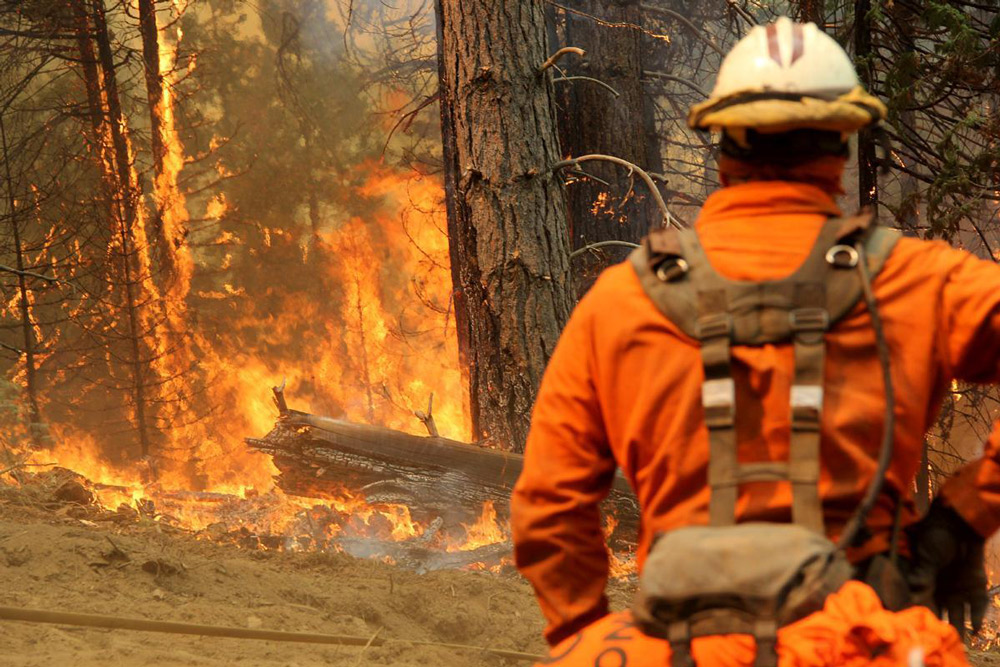
August 2, 2018 - Firefighters worked throughout the day containing spot fires as they made progress toward full suppression of the Ferguson Fire. Officials reported the total footprint of the fire grew by 830 acres throughout the day and was at 69,440 acres as of 6:00 p.m. Containment is at 41 percent.
Firefighters were able to construct containment line around much of the spot fires that prompted the precautionary evacuation of Wawona Wednesday evening. To the north, crews felled snags in preparation for tactical firing toward the spot fire northwest of Merced Grove. Smoke and containment operations resulted in the closure of Big Oak Flat Road (Highway 120). The road remains closed between Crane Flat and the Big Oak Flat entrance of Yosemite National Park. At this time, the only entrance into the park is Lee Vining (Highway 120) to Crane Flat.
Firefighters tended to a new spot fire a couple miles east of El Portal, while crews continued preparing containment lines along the 30X Road to buffer Yosemite West. Structure specialists were stationed within Yosemite West and Foresta.
The high pressure system above the fire is weakening throughout the week, resulting in warmer and drier conditions. This will increase fire behavior. Residents will continue to see smoke columns during the next few days. Residents can monitor air quality and health advisories at:
· https://wildlandfiresmoke.net/outlooks/YosemiteArea
· https://wildlandfiresmoke.net/outlooks/SouthernSierra
CAL FIRE exited Unified Command at 6 a.m. today because of reduced threats to state and private lands. CAL FIRE remains committed to the Ferguson Incident as an assisting agency. California Interagency Incident Management Team 3, led by Incident Commander Mark von Tillow, will assume management of the Ferguson Fire at 6:00 a.m. Friday, August 3.
Community Meeting: Representatives from the Incident Management Team, U.S. Forest Service and Mariposa County Sheriff’s Office will discuss the current fire situation and suppression efforts during a community meeting at 6 p.m. Friday, Aug. 3, at the Mountain Christian Center, 40299 Highway 49, in Oakhurst.
Stanislaus National Forest closure: Stanislaus National Forest officials closed several roads and trails on the Groveland Ranger District within the vicinity of the Ferguson Fire. The closure order spans from Ferguson Ridge in the south to Pilot Ridge in the north. The closure is expected to be in effect until Sept. 30.
Yosemite National Park closure: Yosemite National Park officials extended closures of Yosemite Valley, Wawona Road, the Mariposa and Merced groves of giant sequoias, Hetch Hetchy and other areas through August 5, conditions permitting. For more information, go to nps.gov/yose or call 209-372-0200.
Mandatory Evacuations: Areas that are currently under a mandatory evacuation include:
· Anderson Valley
· Foresta
· Old El Portal
· Old Yosemite Road
· River Road from Briceburg to the last BLM campground
· Wawona
· Yosemite View Lodge
· Yosemite West
Advisory Evacuations: This is NOT an Evacuation Order. This is an advisement only of a potential Evacuation Order should conditions change.
· Cedar Lodge/Indian Flat Campground
· El Portal Trailer Court
· Rancheria Flat – Government Housing
· Savage’s Trading Post
Road Closures:
· Anderson Valley Road
· Big Oak Flat Road (Highway 120) from entrance of Yosemite National Park to Crane Flat.
· Foresta Road
· Incline Road and Highway 140 from the entrance of Yosemite National Park to 1.5 miles east of Midpines, except to residents
· River Road from Briceburg to the gate at Railroad Flat and all campground areas along Highway 140
· Summit Road
· Old Yosemite Road (Coulterville Road)
· Wawona Road (Highway 41) between Chilnualna Falls Road in Wawona and Bridalveil Falls parking lot in Yosemite Valley
Animal Shelters:
· Small animals: Mariposa SPCA, 5599 Highway 49 North, Mariposa, CA 95338
· Large animals: 5007 Fairgrounds Road, Mariposa, CA 95338