


CLICK HERE FOR A LARGE MAP (3,000 Pixels Wide and 3MB)
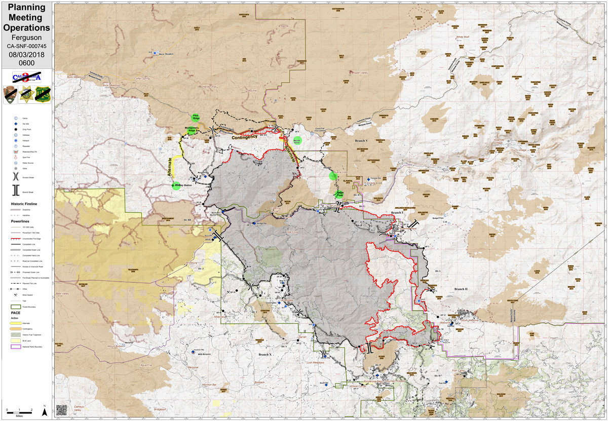
August 3, 2018 - Friday Planning Meeting Operations Map of the Ferguson Fire in Mariposa County near Yosemite National Park.
This map also shows the footprint of historical fires in the surrounding area.
Friday Mornings Information
Engines: 136 Water Tenders: 50 Helicopters: 14 Crews: 66 Dozers: 38 Total Personnel: 2,845
Firefighters made progress throughout the night toward full suppression of the Ferguson Fire, as the management of the fire changed hands. Officials reported the fire grew by 4,120 acres throughout the night and was at 73,560 acres as of 6 a.m. Containment is at 41 percent.
California Interagency Incident Management Team 3, led by Incident Commander Mark von Tillow, assumed management of the Ferguson Fire at 6 a.m. today.
On the north side of the fire, crews performed tactical firing toward the spot fire northwest of Merced Grove. They also fired westward along Pilot Ridge toward the 13 Road to strengthen containment lines.
Big Oak Flat Road (Highway 120) remains closed between Crane Flat and the Big Oak Flat entrance of Yosemite National Park to facilitate suppression efforts. At this time, the only entrance into the park is Lee Vining (Highway 120) to Crane Flat.
East of the fire, crews successfully connected their containment line to Wawona Road (Highway 41). They will progress north along Wawona Road as part of a larger strategy to contain fire spreading southeast between El Portal and Yosemite West.
Firefighters completed initial containment lines around two spots fires southwest of Wawona. Crews will monitor and improve lines around the fire before they complete tactical firing operations along Wawona Road.
Warmer and drier conditions persist in the area, resulting in increased fire behavior and spotting. Residents will continue to see smoke columns during the next few days. Residents can monitor air quality and health advisories at:
· https://wildlandfiresmoke.net/outlooks/YosemiteArea · https://wildlandfiresmoke.net/outlooks/SouthernSierra
Community Meeting: Representatives from the Incident Management Team, U.S. Forest Service and Mariposa County Sheriff’s Office will discuss the current fire situation and suppression efforts during a community meeting at 6 p.m. tonight at the Mountain Christian Center, 40299 Highway 49, in Oakhurst.
Stanislaus National Forest closure: Stanislaus National Forest officials closed several roads and trails on the Groveland Ranger District within the vicinity of the Ferguson Fire. The closure order spans from Ferguson Ridge in the south to Pilot Ridge in the north. The closure is expected to be in effect until Sept. 30.
Yosemite National Park closure: Yosemite National Park officials extended closures of Yosemite Valley, Wawona Road, the Mariposa and Merced groves of giant sequoias, Hetch Hetchy and other areas through Aug. 5, conditions permitting. For more information, go to nps.gov/yose or call 209-372-0200.
Mandatory Evacuations: Areas that are currently under a mandatory evacuation include:
· Anderson Valley · Foresta · Old El Portal · Old Yosemite Road · River Road from Briceburg to the last BLM campground · Wawona · Yosemite View Lodge · Yosemite West
Advisory Evacuations: This is NOT an Evacuation Order. This is an advisement only of a potential Evacuation Order should conditions change.
· Cedar Lodge/Indian Flat Campground · El Portal Trailer Court · Rancheria Flat – Government Housing · Savage’s Trading Post
Road Closures:
· Anderson Valley Road · Big Oak Flat Road (Highway 120) from entrance of Yosemite National Park to Crane Flat. · Foresta Road · Incline Road and Highway 140 from the entrance of Yosemite National Park to 1.5 miles east of Midpines, except to residents · River Road from Briceburg to the gate at Railroad Flat and all campground areas along Highway 140 · Summit Road · Old Yosemite Road (Coulterville Road) · Wawona Road (Highway 41) between Chilnualna Falls Road in Wawona and Bridalveil Falls parking lot in Yosemite Valley
Animal Shelters: · Small animals: Mariposa SPCA, 5599 Highway 49 North, Mariposa, CA 95338 · Large animals: 5007 Fairgrounds Road, Mariposa, CA 95338

