


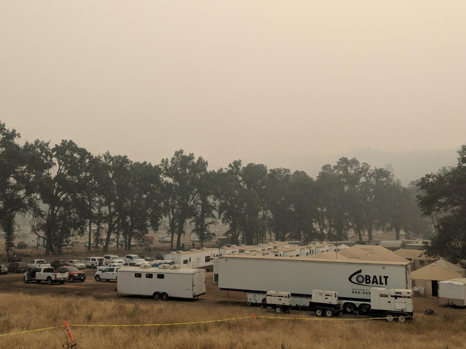
Ferguson Fire ICP August 4, 2018
Credit: Kyle Smith CAIIMT3
August 5, 2018 - 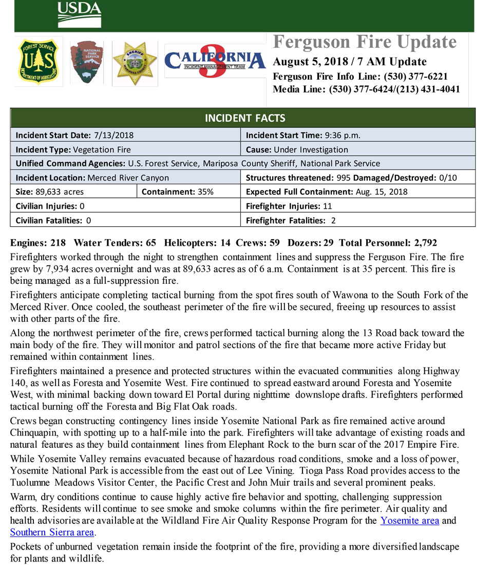

Engines: 218 Water Tenders: 65 Helicopters: 14 Crews: 59 Dozers: 29 Total Personnel: 2,792
Firefighters worked through the night to strengthen containment lines and suppress the Ferguson Fire. The fire grew by 7,934 acres overnight and was at 89,633 acres as of 6 a.m. Containment is at 35 percent. This fire is being managed as a full-suppression fire.
Firefighters anticipate completing tactical burning from the spot fires south of Wawona to the South Fork of the Merced River. Once cooled, the southeast perimeter of the fire will be secured, freeing up resources to assist with other parts of the fire.
Along the northwest perimeter of the fire, crews performed tactical burning along the 13 Road back toward the main body of the fire. They will monitor and patrol sections of the fire that became more active Friday but remained within containment lines.
Firefighters maintained a presence and protected structures within the evacuated communities along Highway 140, as well as Foresta and Yosemite West. Fire continued to spread eastward around Foresta and Yosemite West, with minimal backing down toward El Portal during nighttime downslope drafts. Firefighters performed tactical burning off the Foresta and Big Flat Oak roads.
Crews began constructing contingency lines inside Yosemite National Park as fire remained active around Chinquapin, with spotting up to a half-mile into the park. Firefighters will take advantage of existing roads and natural features as they build containment lines from Elephant Rock to the burn scar of the 2017 Empire Fire.
While Yosemite Valley remains evacuated because of hazardous road conditions, smoke and a loss of power, Yosemite National Park is accessible from the east out of Lee Vining. Tioga Pass Road provides access to the Tuolumne Meadows Visitor Center, the Pacific Crest and John Muir trails and several prominent peaks.
Warm, dry conditions continue to cause highly active fire behavior and spotting, challenging suppression efforts. Residents will continue to see smoke and smoke columns within the fire perimeter. Air quality and health advisories are available at the Wildland Fire Air Quality Response Program for the Yosemite area and Southern Sierra area.
Pockets of unburned vegetation remain inside the footprint of the fire, providing a more diversified landscape for plants and wildlife.
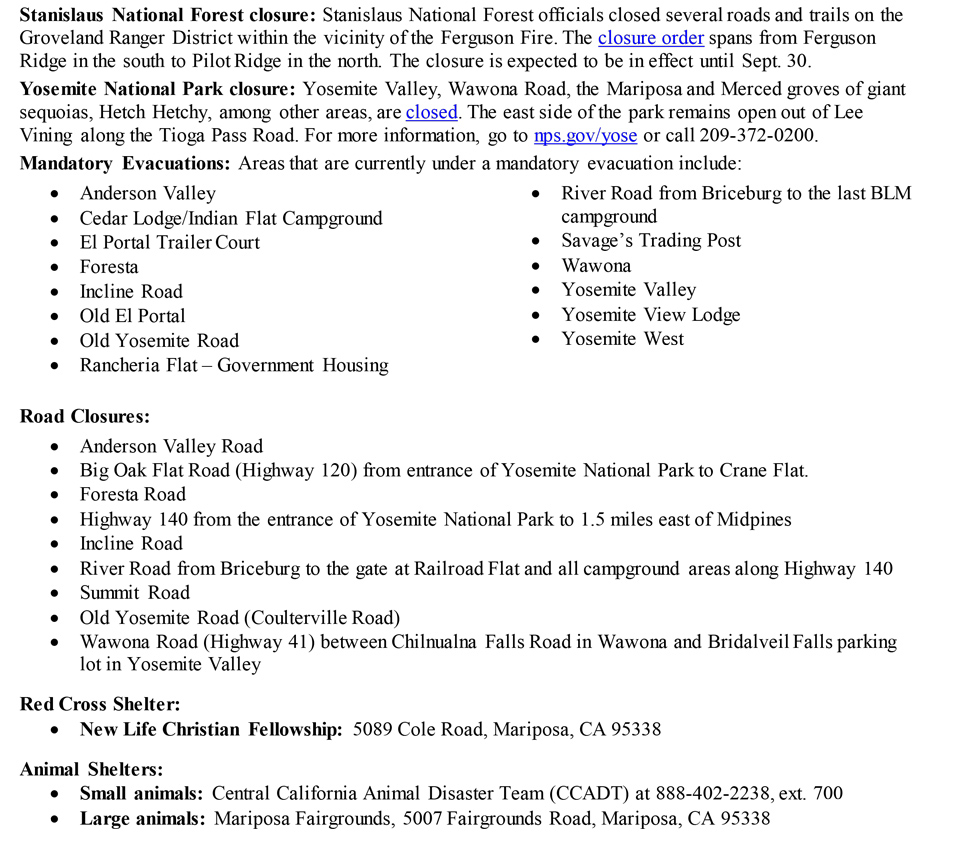
Stanislaus National Forest closure: Stanislaus National Forest officials closed several roads and trails on the Groveland Ranger District within the vicinity of the Ferguson Fire. The closure order spans from Ferguson Ridge in the south to Pilot Ridge in the north. The closure is expected to be in effect until Sept. 30.
Yosemite National Park closure: Yosemite Valley, Wawona Road, the Mariposa and Merced groves of giant sequoias, Hetch Hetchy, among other areas, are closed. The east side of the park remains open out of Lee Vining along the Tioga Pass Road. For more information, go to nps.gov/yose or call 209-372-0200.
Mandatory Evacuations: Areas that are currently under a mandatory evacuation include:
· Anderson Valley
· Cedar Lodge/Indian Flat Campground
· El Portal Trailer Court
· Foresta
· Incline Road
· Old El Portal
· Old Yosemite Road
· Rancheria Flat – Government Housing
· River Road from Briceburg to the last BLM campground
· Savage’s Trading Post
· Wawona
· Yosemite Valley
· Yosemite View Lodge
· Yosemite West
Road Closures:
· Anderson Valley Road
· Big Oak Flat Road (Highway 120) from entrance of Yosemite National Park to Crane Flat.
· Foresta Road
· Highway 140 from the entrance of Yosemite National Park to 1.5 miles east of Midpines
· Incline Road
· River Road from Briceburg to the gate at Railroad Flat and all campground areas along Highway 140
· Summit Road
· Old Yosemite Road (Coulterville Road)
· Wawona Road (Highway 41) between Chilnualna Falls Road in Wawona and Bridalveil Falls parking lot in Yosemite Valley
Red Cross Shelter:
· New Life Christian Fellowship: 5089 Cole Road, Mariposa, CA 95338Red Cross Shelter is located at New Life Christian Fellowship, 5089 Cole Road, Mariposa, CA.
Animal Shelters:
-
Small animals: Central California Animal Disaster Team (CCADT) at 888-402-2238, ext. 700
-
Large animals: Mariposa Fairgrounds, 5007 Fairgrounds Road, Mariposa, CA 95338

