


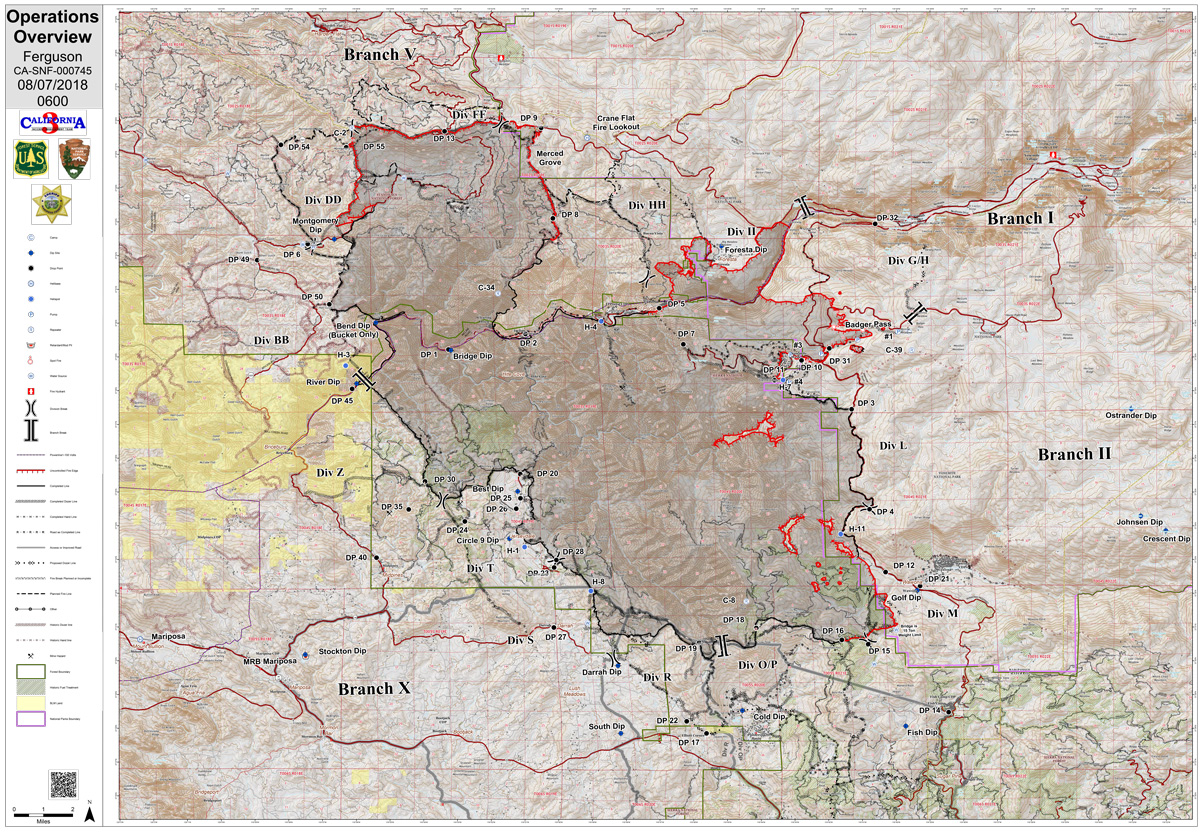
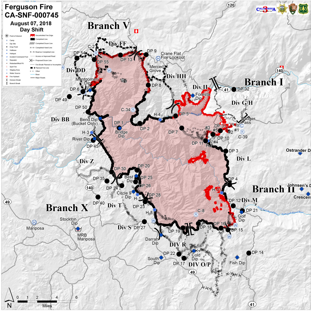
Tuesday Operations Map
CLICK HERE FOR A LARGE MAP (3,000 Pixels Wide and 3MB)
CLICK HERE FOR A LARGE MAP (3,000 Pixels Wide and 3MB)
August 7, 2018 - Tuesday Operations Map of the Ferguson Fire in Mariposa County near Yosemite National Park.
Monday Evening Information
August 6, 2018 - The Ferguson Fire grew by 2,829 acres throughout the day and is at 94,331 acres as of 6:00 p.m. Containment is at 39 percent. This fire is being managed as a full-suppression fire.
Moderate fire behavior today allowed firefighters to make significant progress around the fire perimeter. Firefighters were able to hold the northern portion of the fire within containment lines and complete the firing operation along Montgomery Ridge. Once cooled, the northern perimeter of the fire will be secured, freeing up resources to assist with other parts of the fire.
Firefighters constructed direct hand line above El Portal and Old El Portal. Direct hand line is constructed near the fire’s edge. These successful operations permitted Mariposa Sherriff to lift the evacuation of the El Portal area.
Crews were able to reinforce dozer and hand line around the community of Foresta. Firefighters are patrolling and mopping up this section of hand line. Mopping up is the term firefighters use when removing hazard trees and extinguishing hotspots near containment lines. Once the hand line is completely cooled and hazards are removed, that portion of the fire will be declared contained. Containment indicates the portion of the fire that fire officials are confident that the fire will not cross.
Tactical firing operations will begin tonight along Wawona Road (Highway 41) toward Cascades picnic area. Firefighters will patrol along Highway 120 to ensure the fire stays between Wawona Road and Highway 120. A combination of dozer and hand line was established using a former service road leading to Badger Pass. This containment line will restrict the southern spread of fire into Yosemite National Park.
Structure defense specialists and law enforcement remained within the remaining evacuated communities.
Yosemite Valley and other nearby destinations remain closed due to increased fire activity. National Park officials reported fire has impacted all roads into the valley. Steep terrain, dense forests of beetle-killed trees, unstable slopes and other hazards have made securing the area a challenge.
Yosemite National Park is accessible from the east out of Lee Vining. Tioga Pass Road provides access to the Tuolumne Meadows Visitor Center, the Pacific Crest and John Muir trails and several prominent peaks.
Fire behavior will decrease as a slight change in the weather occurs. Vegetation is dry and the potential for the fire to spread rapidly remains a possibility. Residents will continue to see smoke and multiple smoke columns. Air quality and health advisories are available at the Wildland Fire Air Quality Response Program for the Yosemite area and Southern Sierra area.
The fire has burned at varying intensities throughout the fire’s footprint to leave a diversity of landscape characteristics which benefit vegetation and wildlife.
Stanislaus National Forest closure: Stanislaus National Forest officials closed several roads and trails on the Groveland Ranger District within the vicinity of the Ferguson Fire. The closure order spans from Ferguson Ridge in the south to Pilot Ridge in the north. The closure is expected to be in effect until Sept. 30.
Yosemite National Park closure: Yosemite Valley, Wawona Road, the Mariposa and Merced groves of giant sequoias, Hetch Hetchy, among other areas, are closed. The east side of the park remains open out of Lee Vining along the Tioga Pass Road. For more information, go to nps.gov/yose or call 209-372-0200.
Mandatory Evacuations: Areas that are currently under a mandatory evacuation include:
- Anderson Valley
- Foresta
- Old Yosemite Road
- Yosemite Valley
- Yosemite West
Road Closures:
- Anderson Valley Road
- Big Oak Flat Road (Highway 120) from entrance of Yosemite National Park to Crane Flat.
- Foresta Road
- Highway 140 from the entrance of Yosemite National Park to 1.5 miles east of Midpines (Open to RESIDENTS ONLY)
- River Road from Briceburg to the gate at Railroad Flat and all campground areas along Highway 140
- Summit Road
- Old Yosemite Road (Coulterville Road)
- Wawona Road (Highway 41) between Chilnualna Falls Road in Wawona and Bridalveil Falls parking lot in Yosemite Valley
Red Cross Shelter:
- New Life Christian Fellowship: 5089 Cole Road, Mariposa, CA 95338
Animal Shelters:
- Small animals: Central California Animal Disaster Team (CCADT) at 888-402-2238, ext. 700
- Large animals: Mariposa Fairgrounds, 5007 Fairgrounds Road, Mariposa, CA 95338

