


Above normal temperatures expected to continue into the fall into early winter.
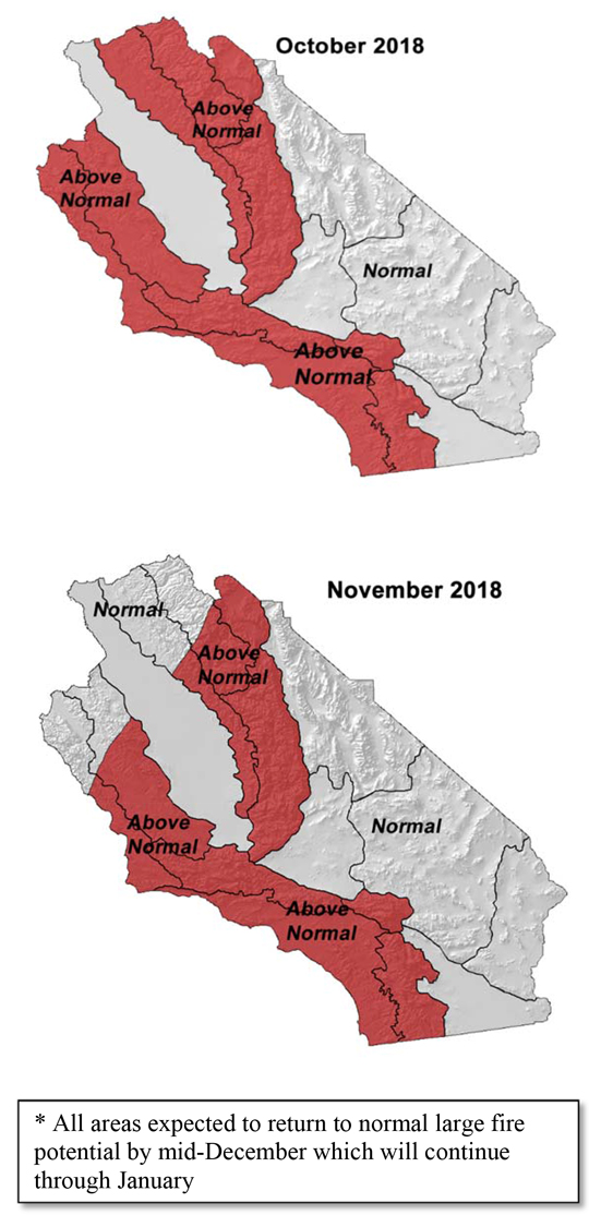
Above normal large fire potential most areas, slowly decreasing from north to south in the fall.
Near normal number of offshore wind events expected through December.
Near normal amount
Weather Discussion
October 3, 2018 - The cooler streak of weather that began in August continued well into September as onshore flow and southwesterly flow kept conditions quite temperate.
 There were few truly “hot” days across the region as the dominating ridges usually seen in September remained far off the coast. A few troughs brought light wetting rains to Northern California early in the month which helped diminish wildfire activity there. Across South Ops’ area, resource demand was unusually light for late summer and the Preparedness Level dropped to 2 (with 5 being highest) during the third week of the month. No meaningful precipitation fell across the district.
The pattern of “troughiness” is expected to continue during the first week of October. In fact, at the time of this writing, a storm system centered on the 2nd of October appears poised to bring some wetting rains to Southern California. But the trough pattern is not expected to continue to be the prevailing longwave feature this fall as nearly all long range models depict a warmer and drier fall and early winter.
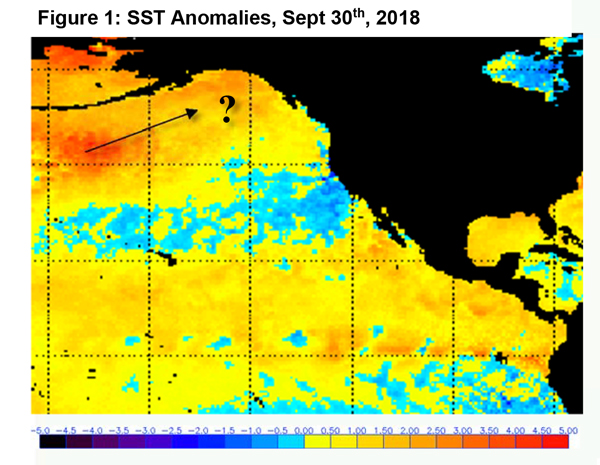
This prognosis would imply a later than usual start to the “winter rainy season” again this year. Sea surface temperatures (SST) remain slightly above normal across the equatorial Pacific as a whole (Figure 1, below). An eastward shift in the warmest SST anomalies may take place, but this may not occur until December, or later.
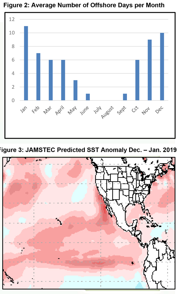
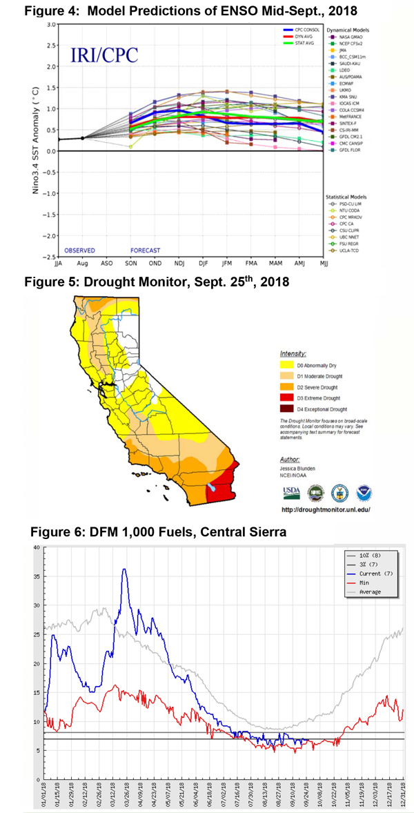
Until then, SST across the equator may mimic a Modoki El Niño which often keeps the district drier than a typical El Niño where warmer SST are more evenly distributed. The JAMSTEC model predicts this pattern to continue into the winter (Figure 3, below) while other models predict the opposite. It remains to be seen which scenario will play out, but there is better consensus about the overall expected strength of this winter’s positive ENSO and when the peak of the warmest SST may occur (Figure 4, below)
The warmer, drier pattern may also be compounded by the recent emergence of warmer than normal SST near the Aleutian Islands. Perhaps this “blob” of relatively warm water will continue migrating toward the Gulf of Alaska. Should this occur, it may lead to fewer storms developing in this area due to mid and upper level high pressure areas which are usually found in the vicinity of these warmer than average waters in high latitudes.
Given this set of initial conditions, it appears there is a high certainty that this fall will be warmer than normal. Last year’s extremely hot weather in October and late November into December were driven partially by a negative ENSO and strong ridging over the Gulf of Alaska. Both of these conditions will likely be absent this fall, so by comparison, this fall and early winter should be cooler than last year.
The number of offshore wind events is still expected to be close to normal. October is usually the month when the frequency and intensity of offshore winds quickly increases, but this year, there may be around 6 notable events this month. Expect below normal offshore activity to continue into the winter, but it still likely that there will be a few offshore wind event prior to the onset of widespread, meaningful precipitation due to a possible delay in winter rainfall.
Fuels and Drought Outlook
Fuel conditions continued to dry in a typical late summer/early fall rate, albeit a few weeks ahead of schedule. Most areas experienced live fuel moisture drop to critically low levels (generally measured at under 60%) by the start of September. Live fuel moisture was generally lowest across Southern California away from the coast. Across the Sierras, a dry close to the summer monsoon also allowed live fuels to drop to critically dry levels in all but the highest elevations.
Dead fuels are at, or are very close to record low fuel moisture values in the larger diameter trees and shrubs (Figure 6, below). These fuels will likely remain very dry until seasonal winter rains arrive. A few eastern desert areas may see enough rainfall from Hurricane Rosa to keep from drying out. But the rest of the area will only see brief, if any, impacts from rainfall in early October. There are still many warm days ahead with strong sunshine and 10-12 hours of daylight to dry out fuels. In the past, it has taken up to 2 inches of rainfall to change fuel moisture significantly in the early fall. (The Freeway fire in the Chino Hills started only a few days after a wetting rain occurred in northern Orange and Western Riverside County.)
Therefore, large fire potential is expected to remain above normal until late fall and early winter given the expectation of warmer than average temperatures. Large fire potential should drop from north to south before dropping to near normal levels across Southern California in December.
Drought conditions are expected to expand and intensify this fall, but there may be a flip to a wetter pattern toward the end of the calendar year. Analog years such as 1986- 1987 and 2006-2007 which featured weak to low end moderate positive ENSO conditions following La Nina the previous winter show below average precipitation across the state with the greatest deficits over Northern California. Both of those seasons saw a slow start to the rainy season, but precipitation did increase during the middle to latter parts of the winter. While this winter may not start off quite as hot and dry as last year, it seems likely that there will be some IA and resource demand over the district until the winter.
Source: Predictive Services

