


Statistics
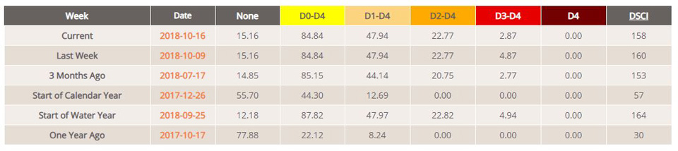
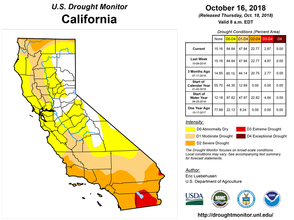
California and National Drought Summary for October 16, 2018
Summary
October 18, 2018 - A wet weather pattern persisted across most of the nation, as the active Atlantic and Eastern North Pacific Hurricane Seasons continued. Hurricane Michael rapidly intensified just prior to slamming ashore in the Florida Panhandle, producing heavy rain across portions of the Southeast but causing fatalities as well as widespread, locally catastrophic damage to homes, businesses, infrastructure, and agriculture. Out west, moisture associated with Hurricane Sergio triggered additional moderate to heavy rain across the lower Four Corners Region. Abundant moisture associated in part with the remnants of Sergio also led to another round of heavy rain from Texas northeastward into the middle Mississippi Valley. Likewise, rain and snow afforded drought relief from the central and northern Rockies into the upper Midwest. The unsettled conditions continued across the southern U.S. after the period ended; any rain that fell after 12z Tuesday morning (8 am, EDT) will be incorporated into next week’s analysis.
Northeast
While rain associated with the remnants of Hurricane Michael stayed along or off the New England Coast, a storm system and its attendant cold front — which helped steer Michael out into the open waters of the Atlantic Ocean — produced moderate to heavy rain (1-3 inches) across the region’s northern tier. Rain was heaviest in northern Maine, where corresponding reductions were made to Abnormal Dryness (D0). Somewhat lighter albeit still beneficial rain from northern New York into northern Vermont led to reductions of D0, Moderate Drought (D1), and Severe Drought (D2). Lingering longer-term precipitation deficits continues, however, with 12-month precipitation still locally less than 70 percent of normal in the Northeast’s drought areas.
Southeast
Hurricane Michael rapidly intensified and slammed into the Florida Panhandle, bringing heavy rain, extreme winds, and a catastrophic storm surge. Rainfall topped 10 inches northeast of Panama City, Florida, while totals of 3 to 7 inches were common along and near the storm’s path from eastern Alabama into western Georgia and the southern Appalachians. In some cases, a two-category reduction to the drought depiction was made where recent heavy rain (30-day rainfall more than 200 percent of normal) has eradicated lingering dryness covering the past 60, 90, 180, and 365 days. Bands of heavy rain (1-4 inches) east of the storm center also brought relief from Abnormal Dryness (D0) and Moderate Drought (D1) in southern South Carolina, though some locales largely missed the rain. In contrast, mostly dry weather prevailed across southern Georgia and northern Florida – where short-term dryness is increasing and D0 may be needed soon — as well as parts of northern and central Alabama (where D0 was added during the past week).
South
Another round of moderate to heavy rainfall — partly associated with remnants of Hurricane Sergio in the eastern Pacific — was responsible for additional widespread reductions of drought intensity and coverage. Much of central and eastern Texas was doused with 2 to 10 inches of rain, with amounts locally more than 12 inches from the Edwards Plateau to Lufkin. This rain fell on top of last week’s downpours, pushing 30-day totals to locally more than 20 inches. During the 7-day monitoring period, the axis of heavy rainfall (2-6 inches) extended east-northeastward across southeastern Oklahoma, Arkansas, northern Louisiana, into western Tennessee; widespread 1- and 2-category reductions were made to the drought analysis, and with more rain falling after the Tuesday-morning cutoff, additional reductions in the lingering Abnormal Dryness (D0) are likely.
Midwest
While much of the Midwest remained free of drought, well-placed rain and snow eased or eliminated lingering dryness in southwestern and northwestern portions of the region. Rain totaled 1 to 4 inches (locally more) from southcentral Missouri northward into eastern Iowa and western Illinois, reducing or eliminating Abnormal Dryness (D0) and Moderate Drought (D1). However, longer-term deficits lingered, with 6-month precipitation locally less than 70 percent of normal in the D1 areas of central and southern Missouri. Meanwhile, the first widespread snow event of the season supplied beneficial moisture to the driest areas of northern Minnesota; snow depths topped 4 inches, with snow-water liquid equivalent locally in excess of one inch supporting a reduction of D0 and D1.
High Plains
The overall trend toward improving conditions continued, with rain and snow on top of last week’s precipitation offering many of the region’s lingering driest areas additional much-needed moisture. In the Dakotas, moderate to heavy snow (nearly 6 inches reported at the NWS office in Grand Forks, ND, on October 10th) afforded a reduction to Abnormal Dryness (D0) to Extreme Drought (D3); two-week precipitation (liquid equivalent) has totaled 1 to 3 inches across the central and eastern Dakotas. Farther south, another wet week in Kansas pushed two-week totals to locally as high as 10 inches, supporting an additional reduction to the state’s Moderate (D1) and Severe Drought (D2). The western flank of this week’s rain added to the recent totals in southeastern Colorado, with 60-day precipitation surpluses of 1 to 4 inches supporting the reduction of D0, D1, and D2. Across the region, the recent rain and snow are helping to recharge water reserves and soil moisture while aiding pasture recovery and improving prospects for winter wheat establishment.
West
The favorable start to the 2018-19 Water Year continued, with rain and mountain snow reported across much of the region. Abundant moisture associated in part with the remnants of Hurricane Sergio led to 1 to 3 inches of rain in southern portions of California and Arizona, while precipitation amounts locally more than an inch (liquid equivalent) were noted from the southern Rockies northward into Montana and the Blue Mountains of northeastern Oregon. The recent rain and mountain snow led to notable reductions of Abnormal Dryness (D0) and Moderate to Exceptional Drought (D1-D4) in Arizona and environs. Furthermore, additional assessment from experts in the field supported reductions to the drought intensity and coverage across eastern New Mexico as well as an adjustment (expansion) of Extreme Drought (D3) in central Utah. Coordination with local experts also supported a reduction of D0 and D2 in southern and northern Idaho, respectively, as impacts begin to subside due to the arrival of seasonably colder weather; furthermore, recent beneficial rain and snow in southcentral portions of the state (30-day precipitation up to 125 percent of normal) further supported the improvement. Despite the generally favorable start to the Water Year, however, areas from the Pacific Northwest southward into central California and the western Great Basin were mostly dry. In particular, Northwestern dryness remained particularly acute in the Cascade Range, with 6-month precipitation departures averaging 4 to 10 inches (locally more than 12 inches below normal).
Alaska, Hawaii, and Puerto Rico
Drought conditions remained unchanged in Alaska as a pronounced change in the weather pattern began to unfold during the period; the arrival of much-needed, locally heavy rain and mountain snow will likely necessitate a thorough reassessment of the state’s coastal drought areas next week. On Hawaii, ongoing improvement from late-September rainfall — including the recovery of vegetation — has taken place, supporting the removal of all Abnormal Dryness (D0) from the state. In Puerto Rico, heavy showers (2-4 inches) all but eliminated lingering D0, though more inland areas around Cayey remained mostly dry.
Looking Ahead
Mostly dry conditions will prevail across the contiguous U.S., with the threat of additional heavy rain confined to Texas. Showers will accompany a strong cold front over the eastern third of the nation Friday into Saturday, but amounts will be generally light. This same front will bring sharply colder weather on gusty winds as well rain and high-elevation snow showers to the northeastern quarter of the nation. In contrast, high pressure will maintain mostly dry weather across the central and western U.S., save for lingering rain and snow showers over the Four Corners States. The NWS 6- to 10-day outlook for October 23 – 27 calls for near- to above-normal precipitation over much of the nation, with the greatest likelihood of wetter-than-normal conditions in the Pacific Northwest, southern Plains, and eastern Gulf Coast. Drier-than-normal weather will be limited to the Great Lakes and Northeast. Warmer-than-normal weather across the eastern half of the nation — save for warmth across the central and eastern Gulf Coast — will contrast with above-normal temperatures from the northern Plains to the Pacific Coast States.
Author(s):
Eric Luebehusen, U.S. Department of Agriculture
Dryness Categories
D0 Abnormally Dry—used for areas showing dryness but not yet in drought, or for areas recovering from drought.
Drought Intensity Categories
D1 Moderate Drought
D2 Severe Drought
D3 Extreme Drought
D4 Exceptional Drought
Drought or Dryness Types
S Short-Term, typically less than 6 months (e.g. agricultural, grasslands)
L Long-Term, typically greater than 6 months (e.g. hydrologic, ecologic)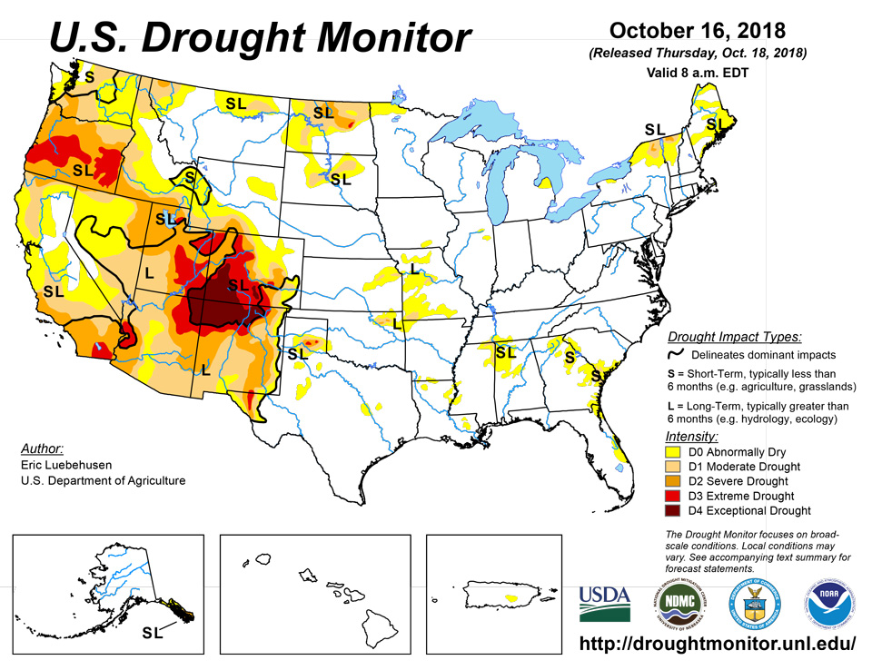
Source: National Drought Mitigation Center

