


Statistics
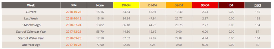
California and National Drought Summary for October 23, 2018
Summary
October 25, 2018 - Outside of additional heavy rain across the southcentral United States, conditions were generally quiet across the Nation. The break from the recent active weather pattern led to a quiet week in the U.S. Drought Monitor, with changes mostly confined to the South. While lingering wetness further reduced or eliminated drought from the Four Corners into Texas, short-term dryness was developing over parts of the Southeast. Note: the weekly drought analysis incorporates rain that has fallen through 12z Tuesday (8 a.m., EDT); any precipitation that falls after the data cutoff will be included in the following week’s assessment. Consequently, the heavy rain — associated in part with the remnants of Eastern Pacific Hurricane Willa — that has impacted (or will impact) much of the southern and eastern U.S. through the weekend will be accounted for next week.
Northeast
Drought conditions were largely unchanged during the period as the region awaits the weekend Nor’easter, though another storm was bringing rain and inland snow to New England after the Tuesday-morning data cutoff. Small additional reductions to Abnormal Dryness (D0) and Moderate Drought (D1) were done in Maine, incorporating updated precipitation data and feedback from local experts in the field. With each passing precipitation event, the drought impacts continue to diminish, and are now mostly reflected in lower-than-normal streamflows and groundwater supplies in the region’s lingering drought areas.
Southeast
Showers in northwestern portions of the region contrasted with generally dry conditions elsewhere. For much of the period (through 12z Tuesday, 8 a.m., EDT), showers (locally more than an inch) were mainly confined from northern Alabama into the southern Appalachians. Rain totals were not sufficient to afford relief from Abnormal Dryness (D0) but nevertheless mitigated concerns over developing short-term deficits, particularly in southcentral Tennessee. Following last week’s sweeping reductions in drought from the Florida Panhandle into northcentral Georgia, modest increases to D0 in southeastern Georgia and northcentral Alabama were coincident with 60-day rainfall below 70 percent of normal (locally less than 50 percent). However, drought experts (local and regional) are awaiting the end-of-week storm and its resultant impacts, which will be incorporated into next week’s assessment.
South
Another round of moderate to heavy rain was responsible for additional widespread reductions of drought intensity and coverage. Much of central and eastern Texas was doused with 2 to 6 inches of rain, with amounts locally more than 10 inches from the eastern Edwards Plateau to College Station. This rain fell on top of downpours from the preceding two weeks, pushing 30-day totals to locally more than 20 inches. As a result, Texas drought was confined to a relatively small area east-southeast of Amarillo at the end of the period, where 365-day precipitation totals remained between 60 and 75 percent of normal. Farther east, moderate to heavy showers (1-5 inches, locally more) also led to additional reduction to the lingering Abnormal Dryness (D0) in northern Louisiana and southern Arkansas. Smaller reductions to D0 and D1 were made in southwestern and northeastern Oklahoma, coincident with locales where another round of rain pushed 180-day precipitation totals to near- or above-normal levels. In contrast, small expansion of D0 was made in northeast Oklahoma in locales which largely missed the recent rain and have subsequently seen deficits at or beyond 6 months begin to climb.
Midwest
While much of the Midwest remained free of drought, rain in southern portions of the region eased lingering dryness. In particular, rain totaling locally more than an inch — on top of a wet October to date — led to the removal of Moderate Drought (D1) in southwestern Missouri. The rest of the Midwestern Abnormal Dryness (D0) and D1 areas were dry but chilly, with temperatures averaging up to 10°F below normal. While the recent dry weather has begun to raise some concerns over short-term moisture deficits, the drier weather has aided corn and soybean harvest efforts overall.
High Plains
After recent improvements to the region’s lingering drought areas, conditions were unchanged during the past week. Mostly dry weather prevailed, with temperatures averaging up to 5°F above normal on the northern Plains. Across the region, recent rain and snow have helped to recharge water reserves and soil moisture while aiding pasture recovery and improving prospects for winter wheat establishment. However, significant longer-term moisture shortages linger in the Moderate to Extreme Drought areas (D1-D3), with precipitation over the past 365 days totaling locally less than 60 percent of normal.
West
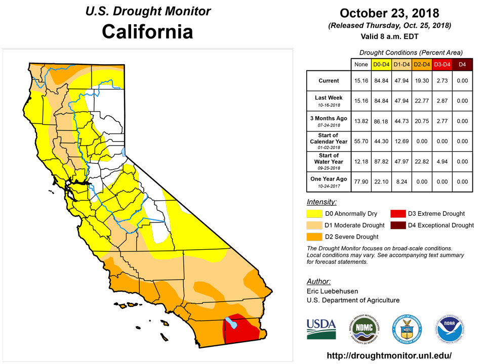
A respite between storms afforded local experts an opportunity for further assessment of the current drought situation, with locally heavy precipitation arriving in southern portions of the region after the drought monitoring period. Precipitation up to the data cutoff (12z Tuesday, or 6 a.m., MDT) generally totaled less than an inch (liquid equivalent), though amounts were locally higher in the Four Corners Region and immediate environs. Modest reductions were made in eastern New Mexico to Abnormal Dryness (D0), Moderate Drought (D1), and Severe Drought (D2), where this week’s rain pushed 6-month precipitation totals to near- to above-normal levels. Farther west in southern California and western Arizona, discussion with local experts as well as a detailed analysis of longer-term precipitation deficits and satellite-derived vegetation health data supported trimming the coverage of D2 and D3 (Severe to Extreme Drought); in particular, 24-month precipitation has climbed to near-normal levels along the California-Arizona border. In contrast, dry weather persisted in Northwestern drought areas, where 180-day precipitation has tallied a meager 20 to 50 percent of normal. Rain and snow will be needed soon to prevent an expansion and intensification of drought across the Northwest. Conversely, another moisture-laden storm was bringing moderate to heavy rain and mountain snow to the lower Four Corners after the end of the monitoring period.
Alaska, Hawaii, and Puerto Rico
Drought conditions remained unchanged in Alaska, though the arrival of a wet weather pattern brought beneficial rain (2-4 inches, locally more) to the state’s southeastern drought areas. Despite this week’s ran and mountain snow, 180-day precipitation remained at or below 60 percent of normal; these longer-term departures highlight the need for sustained rain and snow to cut into the drought. Hawaii remained free of Abnormal Dryness (D0) or drought. In Puerto Rico, heavy showers (2-4 inches) continued, though the rain bypassed the lingering D0 around Cayey.
Looking Ahead
A wet weather pattern is in store for much of the southern and eastern U.S. The combination of moisture associated with the remnants of Hurricane Willa, a pronounced southward dip in the jet stream (a trof), and a blocking high over the northern Atlantic Ocean will lead to a wet and colder weather pattern across the East. The storm responsible will continue to track across the nation’s southern tier, having already produced moderate to heavy rain and localized flooding in parts of the Four Corners Region. The storm will bring moderate heavy rain across the Gulf Coast States before churning slowly up the East Coast over the weekend, producing wind-swept rain and inland snow. A second faster-moving system will follow the Nor’easter, maintaining the threat of rain and high-elevation snow in the Northeast. Meanwhile, much-needed moisture will sweep across Northwestern drought areas in two waves, with the second system early next week potentially leading to fresh snowfall in the central and northern Rockies. Despite the nation’s active weather, the Southwest will turn drier. The NWS 6- to 10-day outlook for October 30 – November 3 calls for near- to above-normal precipitation over much of the nation, with drier-than-normal weather limited to the West Coast and lower Southeast. Cooler-than-normal weather is expected across the eastern third of the nation and from the central Plains to the Great Basin, while above-normal temperatures linger across the western Gulf Coast and in the Pacific Coast States.
Author(s):
Eric Luebehusen, U.S. Department of Agriculture
Dryness Categories
D0 Abnormally Dry—used for areas showing dryness but not yet in drought, or for areas recovering from drought.
Drought Intensity Categories
D1 Moderate Drought
D2 Severe Drought
D3 Extreme Drought
D4 Exceptional Drought
Drought or Dryness Types
S Short-Term, typically less than 6 months (e.g. agricultural, grasslands)
L Long-Term, typically greater than 6 months (e.g. hydrologic, ecologic)
Source: National Drought Mitigation Center

