


• Above normal temperatures likely to continue into the fall into early winter.
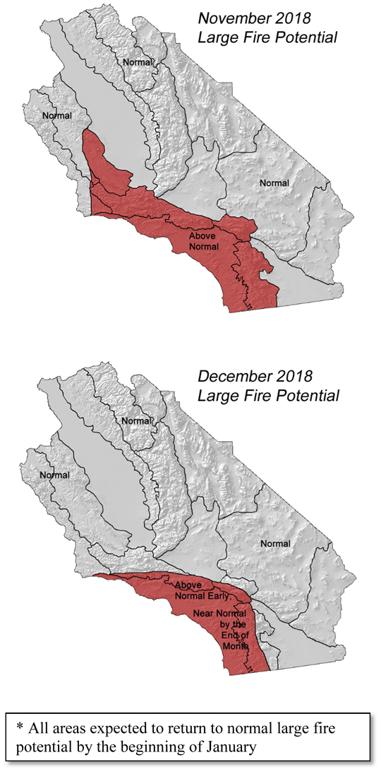
• Above normal large fire potential most areas, slowly decreasing from north to south in November.
• Near normal number of offshore wind events expected through December.
• Below normal amount of rainfall November, possibility turning wetter in December.
Weather Discussion
November 4, 2018 - October, 2018 was generally warmer and drier than normal across the district. High pressure over the eastern Pacific strengthened during the 3rd week of the month which effectively shut off the storm track, leaving
 Southern and Central high and dry. Precipitation deficits last month were generally more extreme over the central part of the state which ordinarily begins to see the beginnings of seasonal rainfalls in October. Such troughs were few and far between and no precipitation was recorded across the central coast and Sierras after the storm system of October 5th and 6th.
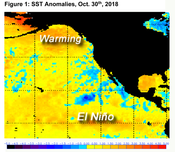
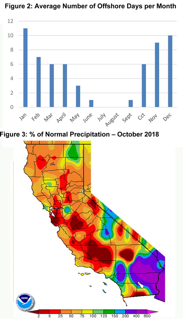
Southern California fared a bit better as remnant moisture from a dissipating tropical system was steered northward. This resulted in widespread showers and thunderstorms (see figure 3, below) particularly from Orange County southward. Several hundred lightning discharges occurred, but fortunately, heavy rain also accompanied the storms and new lightning-related starts were minimal. Rainfall from this unusual weather scenario averaged 2-3 inches and some locations saw heavier rainfall from this particular storm than any that occurred during the previous winter.
The blocking pattern now in place is a familiar one as a strong ridge extending from the Gulf of Alaska southward has been a seemingly ever-present feature during the winter the past few years. This ridge, dubbed the “Triple RRR” by meteorologist Dr. Daniel Swain may (or may not have) begat warm sea surface temperatures (SST) over the Gulf of Alaska. These unusually warm SSTs (aka, “The Blob”) have been present during the peak of winter rainy season in each of the dry years from 2012-2016. The reappearance of warming in this area during the past 4-6 weeks may give one pause as we head to the wetter winter months, but, so far, temperatures in the Gulf are not as warm as during those dry winters. Nor has a well-defined zone of much colder than average SSTs appeared off the California coast. (The small pocket of far below normal SST’s southwest of Baja was likely a result of Willa and other named storms in the area). These temperature contrasts (best illustrated here) across the Pacific may have also had a hand in generating those dry winters.
Most available long term guidance depicts a drier than normal start to the winter rainfall season, perhaps as a tip of the cap to the strong ridge now over the Eastern Pacific. This pattern may evolve into more of a rex block which may favor wetter, but still infrequent, storm systems in December and January. But a transition to a wetter pattern may ensue in December or early January. Long range models begin to trend wetter during this period as well.
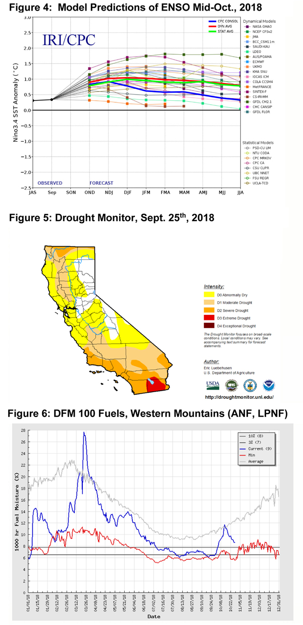
A weak El Niño will continue through the winter into the early spring (Figure 4, bottom of page). However, the highest positive SST anomalies may lie west of the favored Niño 3.4 and ENSO may not be a big determinant of weather patterns this winter. Those hoping for a bounty of ENSO related precipitation this winter will likely be disappointed.
Offshore wind events are still expected to be near to slightly above normal during the month of November. (Normal is seen in the chart below.) If the switch to a wetter pattern ensues in December, offshore events may be substantially fewer in number than average. All models suggest that temperatures will be warmer, or perhaps much warmer, than normal during the next 3 months. In all likelihood, even if temperatures are much warmer than normal, December 2018 will not be as hot as last year.
FUELS AND DROUGHT OUTLOOK
The pair of rain events in early October brought about a pronounced spike in fuel moisture readings in the dead fuels. Most predictive service areas had been showing moisture levels close to record low readings prior to the rain, but the moisture increase allowed dead fuels to briefly achieve above normal readings. But hotter, drier weather at the close of the month caused fuel moisture levels to quickly fall back to well below normal readings (Figure 6, below).
In fact, the rainfall last month had surprisingly little lasting effects in the dead fuels, except for leading to a brief suspension in fire activity. Fuels, at the time of this writing, have once again become highly receptive to ignition during peak heating hours or during windy periods. Some very minor greenup has occurred in seasonal grasses over Southern California, but it’s far too sparse to change fire behavior much.
As has often the case the past few autumns, fire activity will be largely governed by short term weather patterns. Short daylight hours, a low solar angle and more stable conditions will keep rates of spread moderate in the absence of wind. But during windy periods, fire danger will be far above normal for this time of year due to the extreme dryness of the fuels. There is also a very high dead fuel component – especially over Central California – due to the effects of the 5 year drought and the bark beetle.
A landscape dominated by vegetation in frail health will keep large fire potential higher than normal and more subject to the whims of nature. Any prolonged dry period across areas without a heavy amount of live fuel loading will present the potential for elevated large fire potential. Since there is no new significant live fuel growth so far this season, we expect large fire potential will remain above normal over portions of the district this month. As cooler and wetter weather returns, large fire potential should decrease from north to south in November. By the middle of December, sufficient rainfall should lower large fire potential to near normal levels over Southern California.
During the next few weeks, new starts will grow aggressively and will be difficult to suppress during windy periods due to the extreme dryness of dead fuels. Vigilance of changing weather conditions is stressed as well as strict adherence to the 10 standard orders and 18 watch out situations.
Source: Predictive Services

