


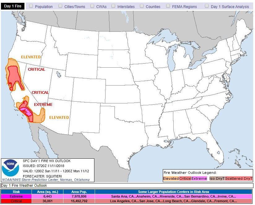
November 11, 2018 - California Fire Weather Outlook for Sunday, November 11, 2018 by National Weather Service Storm Prediction Center.
   Day 1 Fire Weather Outlook
   NWS Storm Prediction Center Norman OK
   0120 AM CST Sun Nov 11 2018

   Valid 111200Z - 121200Z

   ...EXTREMELY CRITICAL FIRE WEATHER AREA FOR PORTIONS OF THE
   CALIFORNIA FOOTHILLS...
   ...CRITICAL FIRE WEATHER AREA FOR PORTIONS OF SOUTHWESTERN
   CALIFORNIA...
   ...CRITICAL FIRE WEATHER AREA FOR PORTIONS OF NORTHERN CALIFORNIA...

   ...Synopsis...
   An amplifying upper-level longwave trough and associated surface
   high will translate east-southeastward during the day, with a
   critically strong pressure gradient fortified across the state of
   California. Strong and widespread north-northeasterly surface winds
   will be prevalent across much of California throughout the period,
   with the strongest winds likely to be observed during the morning
   hours. With critically low RH and dry fuels present across
   California, conditions will be favorable for rapid fire
   spread/growth in multiple locations.

   ...Southern California...
   Strong offshore flow will be in place at the start of the day, with
   the surface winds reaching peak intensity during the late morning
   hours. 20+ mph sustained north-northeasterly surface winds, with
   down to single digit RH values atop very dry fuels, will foster
   widespread critical fire weather conditions across much of
   southwestern California. In addition, channeled flow along terrain
   favoring areas, as well as flow atop the higher terrain of the
   foothills, is expected to reach 30+ mph for several hours during the
   morning, supporting a volatile environment for wildfire potential,
   warranting the continuation of the extremely critical delineation.

   ...Northern California...
   Dry, downsloping flow along the Coast Ranges and the Sierra will
   contribute to critical fire weather conditions along the slopes of
   the higher terrain, into the Sacramento Valley during the mid
   morning to early afternoon hours. Critically low surface RH and 20+
   mph sustained north-northeasterly winds will continue to overlap dry
   fuels in these areas, promoting the rapid spread and growth of any
   new or current wildfires. Thereafter, surface winds will weaken to
   around 15-20 mph for the rest of the period, as the pressure
   gradient begins to relax somewhat across northern California.

   ..Squitieri.. 11/11/2018
Source: NWS
