


Mariposa future rain chances as of Tuesday morning: Wed.: Rain with up to 1.75" possible. Thu.: Rain with less than 0.10" possible. Fri.: Rain with up to .75" possible.
November 20, 2018 - The National Weather Service Hanford office reports the first storm of the season is expected to move through the region beginning Wednesday and continue into Thanksgiving.
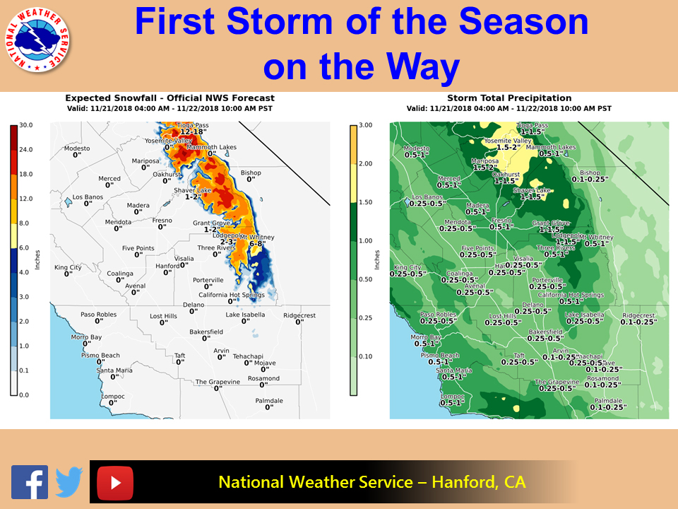
Snow levels are expected to drop to around 7000 feet during the precipitation event. Snow amounts will range from 6 to 15 inches with localized amounts of about 20 inches over the highest elevations of the Sierra Nevada.
Elsewhere, rain is expected, mostly over the northern half of the area.
Greatest amounts will be in the northern parts of the area with valley locations getting up to half of an inch of rain, while higher amounts up to 2 inches in the higher elevations of the Sierra Nevada in the Yosemite area.
Southern parts of the area will see much less with valley, desert, foothills, and mountains seeing up to a quarter of an inch.
Allow extra travel time during this busy holiday week and slow down on wet roads.
  Area Forecast Discussion
  National Weather Service San Joaquin Valley - Hanford CA
  326 AM PST Tue Nov 20 2018

  .SYNOPSIS...High pressure will keep a dry and stagnant airmass
  over the area through tonight. A low pressure system will bring
  cooler temperatures, increased moisture and precipitation to the
  area by Wednesday afternoon. Rain and mountain snow will continue
  through Thanksgiving Day. Another system will bring precipitation
  chances to the area on Friday and Friday Night then move east of
  the area over the weekend as high pressure returns along with a
  drier airmass.

  &&

  .DISCUSSION...A persistent dry and stagnant airmass remains over
  the area as an upper ridge centered over the Great Basin remains
  the dominant weather feature across our region this morning. Once
  again smoke remains trapped in the San Joaquin Valley as inversion
  conditions persist. This will result in one more day of poor air
  quality across the San Joaquin Valley. However, changes are
  coming as the WRF is indicating that the ridge will start breaking
  down later today opening the door for two low pressure systems to
  impact our area later this week.

  The first low pressure system is expected to push into northern
  and central California by Wednesday afternoon and finally mix out
  the stagnant airmass which has persisted across our area for the
  past several days. This system will also spread precipitation into
  the area Wednesday afternoon and evening which will continue
  through Thanksgiving morning. At this time precipitation amounts
  still look to range from generally 0.05-0.15" in the Kern County
  Deserts...0.25-0.50" in the San Joaquin Valley...and from around
  0.50-1.50" in the Southern Sierra Nevada from south to north. The
  biggest concern for our area with this system will be the
  potential for flooding, debris flows and mudslides over recently
  burned areas in the Southern Sierra Nevada including the Ferguson
  Fire burn scar in Mariposa County.

  Snow levels area expected to be around 7000 feet on Wednesday and
  lower to around 5500 to 6000 feet by Thanksgiving morning. A
  Winter Storm Watch remains in effect for elevations above 7000
  feet in the Southern Sierra Nevada where total snow accumulations
  of 6 to 15 inches are expected for our first significant snowfall
  of the season. The precipitation is expect to taper off by
  Thanksgiving afternoon as the low moves east of our area.

  The second low pressure system is expected to spread
  precipitation into northern California by Thanksgiving Night with
  a surge of moisture streaming through Northern California on
  Friday and Friday Night. At this time, the heavier precipitation
  with this second system is expected to remain to the north of our
  area although some light precipitation is still expected across
  our area Friday afternoon and Friday Night with snow levels
  generally between 7000 and 8000 feet with the second system.

  The medium range models are in good agreement in moving the
  second low east into the Great Basin by Saturday. A dry upper
  ridge is then progged to build into CA Saturday Night and Sunday
  and remain the predominant weather feature across our area
  through next Tuesday. Temperatures will recover some over the
  higher elevations while daytime humidities lower once again.
  However, with the return of inversion conditions over the San
  Joaquin Valley, patchy morning fog will be possible by Sunday and
  the fog might become more prevalent by Monday and Tuesday as the
  ridge strengthens.

  .CERTAINTY...

  The level of certainty for days 1 and 2 is high.
  The level of certainty for days 3 through 7 is medium.

  Certainty levels include low...medium...and high. Please visit
  www.weather.gov/hnx/certainty.html for additional information
  an/or to provide feedback.
Source: NWS

