


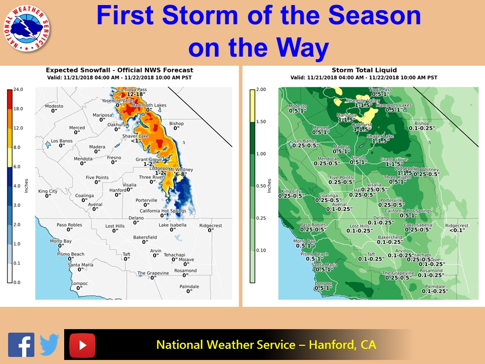
November 21, 2018 - The National Weather Service Hanford office reports the first storm of the season is expected to move through the region beginning Wednesday and continue into Thanksgiving.
Snow levels are expected to drop to around 7000 feet during the precipitation event. Snow amounts will range from 6 to 15 inches with localized amounts of about 20 inches over the highest elevations of the Sierra Nevada.
Elsewhere, rain is expected, mostly over the northern half of the area. Greatest amounts will be in the northern parts of the area with valley locations getting up to half of an inch of rain, while higher amounts up to 2 inches in the highest elevations of the Sierra Nevada in the Yosemite area.
Southern parts of the area will see much less with valley, desert, foothills, and mountains seeing up to a quarter of an inch.
Allow extra travel time during this busy holiday week and slow down on wet roads.
  Area Forecast Discussion
  National Weather Service San Joaquin Valley - Hanford CA
  401 AM PST Wed Nov 21 2018

  .SYNOPSIS...A low pressure system will bring cooler temperatures,
  increased moisture and precipitation to the area by this
  afternoon. Rain and mountain snow will continue into Thanksgiving
  Day. Another system will bring precipitation chances to the area
  on Friday and Friday Night then move east of the area over the
  weekend as high pressure returns along with a drier airmass.


  .DISCUSSION...METARs and webcams are indicating much better
  visibility across the San Joaquin Valley than what was observed on
  Tuesday morning as an incoming trough has provided for increased
  atmospheric mixing. IR imagery is indicating some thin high
  clouds streaming over central CA while the deeper moisture and
  precipitation remain to the north and west of our area.

  After several days of a dry and stagnant airmass prevailing over
  the area, a big change is in store as the offshore trough
  continues to approach the CA coast today and move inland across
  our area tonight. RH progs are trending slower with the arrival
  of the deeper moisture moving into our area, but there is still
  the potential for light precipitation from Fresno County northward
  by late this morning spreading southward this afternoon. The more
  significant precipitation is expected to arrive by this evening as
  the WRF is indicating a 170kt 250mb jet max slicing through
  central CA. With the northern portion of our CWFA expected to be
  in the favored LFQ this evening, moderate to locally heavy
  precipitation will be possible in the Southern Sierra Nevada from
  Fresno County northward. The biggest concern at this time remains
  how the Ferguson Fire burn area in Mariposa County responds to
  the first significant precipitation across our area in a month
  and a half. The potential exists for mudslides and debris flows
  in this area so a Flash Flood Watch has been posted for late this
  afternoon through Thanksgiving morning. This is also expected to
  be the first significant snowfall of the season across the higher
  elevations of the Southern Sierra Nevada and a Winter Storm
  Warning remains in effect for elevations above 7000 feet from for
  late this afternoon through Thanksgiving morning as well.

  This system will move east of our area by afternoon on
  Thanksgiving Day. However, a second system is expected to push
  through Norcal on Thanksgiving Night and spread precipitation
  southward across our area by Friday morning. Although amounts are
  progged to be light with this second system, QPF progs are
  trending a bit higher with it; and this will need to be watched
  for possible impacts across the Ferguson Fire burn area for
  Friday.

  By Saturday the second system will move to the east of our area
  and a dry upper ridge will push into CA on Saturday Night and
  Sunday. The medium range models are in fair agreement with the
  ridge remaining the dominant weather feature across our area
  Sunday through Tuesday which will result in a warming trend and
  lowering daytime humidities. It will also increase the potential
  for significant fog in the San Joaquin Valley on Monday and
  Tuesday mornings. The ridge is progged to break down by next
  Wednesday, and both the GFS and ECMWF are indicating a potentially
  strong storm moving through Central CA by the end of next week
  which would bring additional precipitation to our area.


  CERTAINTY...

  The level of certainty for days 1 and 2 is high.
  The level of certainty for days 3 through 7 is medium.

  Certainty levels include low...medium...and high. Please visit
  www.weather.gov/hnx/certainty.html for additional information
  an/or to provide feedback.
Source: NWS
