


California and National Drought Summary for November 20, 2018
Summary
November 22, 2018 - The upper-level circulation during this U.S. Drought Monitor (USDM) week consisted of a trough over the eastern contiguous U.S. (CONUS) and a ridge over the west coast. The trough, with its northwesterly flow, funneled cold and dry Canadian air masses into the central and eastern CONUS. Below-normal temperatures spread across most of the CONUS, with weekly temperature departures more than 15 degrees below normal across parts of the central Plains to Midwest. The cold fronts were fed by Gulf of Mexico and Atlantic moisture when they reached the southern and eastern coasts. Low pressure systems tracked along the fronts to produce an inch of precipitation along the Gulf Coast, and 1 to locally over 2 inches across much of the country from the Tennessee and Ohio valleys to East Coast. The precipitation in the East was enhanced by a slow-moving upper-level low early in the week. The western ridge deflected Pacific storm systems away from the western CONUS and into southern Canada, making for a very dry week across much of the West with no precipitation recorded. The ridge also enhanced high surface pressure over the Great Basin, which produced strong Santa Ana winds that fanned devastating wildfires over California. As they tracked around the top of the ridge, some of the Pacific systems combined with the Canadian cold fronts to generate areas of precipitation in Washington, the northern and central Rockies, and a few areas in the northern Plains. Other than these few areas of precipitation, the Plains to Mississippi Valley were mostly dry with well less than half an inch of precipitation falling. Drought and abnormal dryness contracted in parts of Montana, North Dakota, and the Southwest. It expanded in a few areas and contracted in others in the Southeast. Moderate or severe drought expanded across a large part of California into Nevada, and in parts of the Pacific Northwest.
Northeast
An inch or more of precipitation fell across much of the Northeast this week, with some areas receiving 2 or more inches. However, only 0.5-1.0 inch was noted across the northern portions of New England and New York, which is where D0 lingered. The D0 represents lingering dryness at longer time scales (3 months or longer), as reflected in several drought indicators, so no change was made to the depiction in the Northeast.
Southeast
Except for parts of western Alabama, the southern half of Florida, and a few strips along the Georgia and South Carolina coast, half an inch or more of rain fell across the Southeast, with more than 2 inches in a band from the Florida panhandle to western and central North Carolina. D0-D1 were trimmed in some areas, and expanded in others, along the Georgia and South Carolina coast, depending on the precipitation anomaly patterns for the past week to last 3 months. This week’s rainfall trimmed the western edge of the D0 in southern Florida, but D1 was added where 3-month precipitation deficits were in the moderately dry category, according to the Standardized Precipitation Index (SPI), SPEI (Standardized Precipitation Evapotranspiration Index), KBDI, streamflow, and soil moisture indicators. D1 also expanded along the east coast of Florida.
South
Rain was falling across southeast Texas and the western Gulf Coast as the week ended, and half an inch or more of rain fell across much of Tennessee, but otherwise the week was dry across the South. No change was made to the few areas of D0-D1 in Texas, Oklahoma, and Arkansas.
Midwest
Precipitation ranged from less than a tenth of an inch in western portions of the Midwest to over an inch in eastern portions. The D0 in Missouri and Minnesota reflected lingering long-term dryness, and the rest of the Midwest has been wet in recent weeks. D0 was pulled back out of Lake of the Woods County in Minnesota based on improving lake conditions, but otherwise no change was made to the depiction in this region.
High Plains
The northern to central Plains were cold this week and most areas were dry. A swath of above-normal precipitation, which amounted to 0.5-1.0 inch, stretched from northeast Montana to northeast South Dakota, with other patches in Wyoming and southeast Nebraska. D0 contracted in north central Montana and southwest North Dakota where precipitation was above normal this week and above normal (wet) for most of the time scales for the last 2 years. According to November 18 reports from the USDA, topsoil moisture was short or very short across 26% of North Dakota and 39% of Wyoming. D0 contracted in Colorado, basically over Boulder County which was a foot of snow above average to start the snow season, and not showing any long-term precipitation deficits.
West
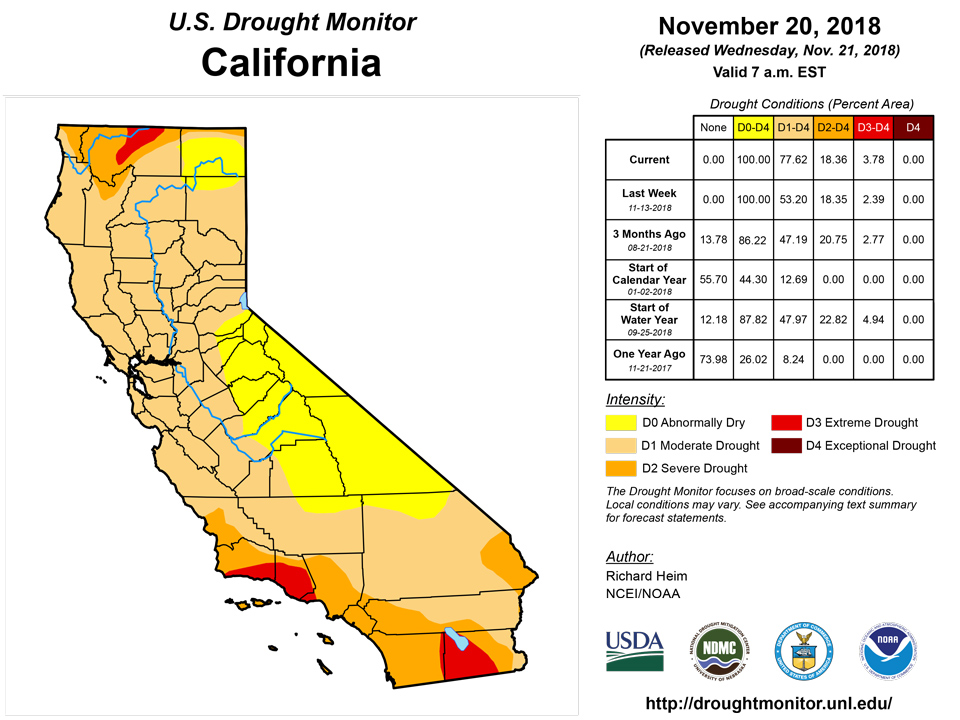
Parts of western Washington received 0.5-1.0 inch of precipitation this week, with a few spots up to 2 inches, but outside of the Pacific Northwest, the West was bone dry. D1 expanded from northeast Oregon into southeast Washington where precipitation deficits were growing. The SPI showed moderately dry conditions there at many time scales from the last 1 to 24 months. In California, a number of indicators showed moderate drought or worse conditions across the state. These included the SPI, SPEI, KBDI, streamflow percentiles, soil moisture models, and groundwater indices, and low snowpack in the Sierra Nevada. Agricultural impacts collected by the University of California Cooperative Extension and the USDA indicated worsening conditions across parts of coastal, central, and northeastern California. These impacts included reduced pasture and forage, hauling of water, livestock stress, decrease in water allocation, increased fire danger, dry wells, and low ponds and springs. D1 was expanded from central coastal California, across northeast California and into northern Nevada, and a sliver of D3 was added to Santa Barbara and Ventura Counties, to reflect these conditions and indicators. According to November 18 USDA reports, topsoil was short or very short of moisture across 75% of California, 95% of Nevada, 66% of Oregon, and 48% of Washington. Except for northern California, reservoir levels in California were near or above average, indicating that the state’s water managers have done an excellent job managing water resources during the significant drought of the last several years.
Even though no precipitation fell this week, a reassessment of conditions led to contraction of drought and abnormal dryness in parts of the Southwest. Heavy rainfall from the remnants of several Pacific tropical systems during the last couple months brought precipitation totals into the surplus category at many, if not most, time scales from the last 1 to 6 months across southern and eastern New Mexico, and out to 24 months for parts of southeast Arizona and southern New Mexico. This was reflected in several indicators, including SPI, SPEI, soil moisture models, and the satellite-based GRACE groundwater index. A one-category improvement of D0-D2 was made across parts of southern, eastern, and central New Mexico, and D1 was pulled back in southeast Arizona and adjacent southwest New Mexico.
Alaska, Hawaii, and Puerto Rico
No change was made to the depiction in Hawaii, Alaska, and Puerto Rico this week. The last seven days have been drier than normal across Hawaii, but widespread wet conditions were the rule at longer time scales, from 30 days to 12 months, due to tropical and frontal rains that have fallen in recent months. A mixed precipitation anomaly pattern for the last 7 days occurred across Alaska. It was wetter than normal across most of the D0-D1 area in the panhandle, but the long-term precipitation deficits (out to 3 years) are so severe that the recent precipitation has had little effect on reducing the deficits. It was near to wetter than normal during the last 7 days across most of Puerto Rico, except over the south central (where the D0 is), southwest, and west central sections. There were spotty reports of below-normal streamflow, and soil moisture was still dry along the southern coast.
Looking Ahead
A Pacific weather system was poised to bring precipitation to the West Coast as this USDM week ended. Over the next 7 days, the Pacific weather system will move across the West, pushing the ridge further to the east, and reforming as a frontal system that moves across the Plains to East Coast, with another Pacific system moving into the West on its heels. The NWS WPC 7-Day Quantitative Precipitation Forecast (QPF) for November 21-27 calls for 3+ inches of precipitation across much of the West Coast from northern California to Washington, with half an inch to an inch or more further inland to the northern and central Rockies. The precipitation is forecast to miss most of southern California and the Southwest. Little to no precipitation is in the QPF in the northern and southern Plains, while a band of 0.1 to 0.5 inch stretches across the central Plains. The QPF has an inch or more of precipitation across much of the country along and east of the Mississippi River, with 2 inches or more in parts of the Gulf Coast and southern Appalachians to New England. The central part of the CONUS will get a shot of above-normal temperatures as the ridge propagates east, then below temperatures will return. The CPC 6-10 day and 8-14 day outlooks envision a ridge re-establishing itself across the West and a trough over the East. As a result, warmer-than-normal temperatures are expected across Alaska and the Rockies to West Coast, with colder-than-normal temperatures expected to dominate from the Plains to East Coast, except New England. November 26-December 4 is expected to be wetter than normal in Alaska, along the West Coast, along the northern tier states, in New England, and in Florida, and drier than normal across the southern Plains to Lower Mississippi Valley.
Author(s):
Richard Heim, NOAA/NCEI
Dryness Categories
D0 Abnormally Dry—used for areas showing dryness but not yet in drought, or for areas recovering from drought.
Drought Intensity Categories
D1 Moderate Drought
D2 Severe Drought
D3 Extreme Drought
D4 Exceptional Drought
Drought or Dryness Types
S Short-Term, typically less than 6 months (e.g. agricultural, grasslands)
L Long-Term, typically greater than 6 months (e.g. hydrologic, ecologic)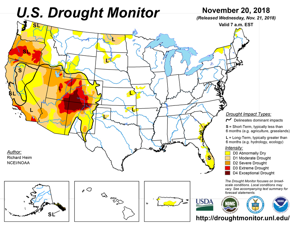
Source: National Drought Mitigation Center

