


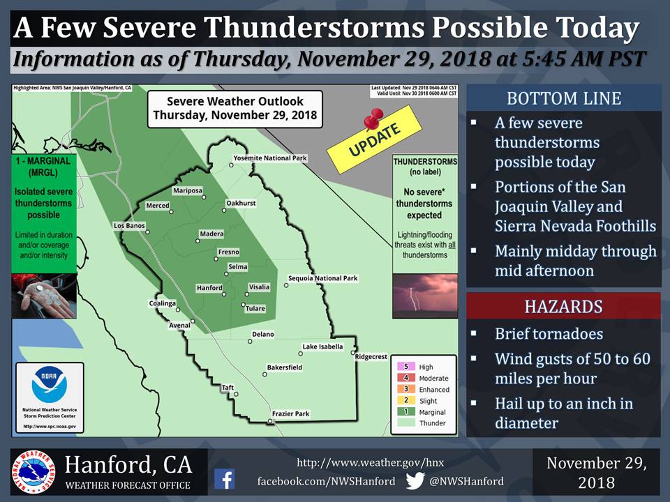
November 29, 2018 - The National Weather Service Hanford office reports a few severe thunderstorms in Mariposa County, Madera County and the Central Valley are possible today.
  Area Forecast Discussion
  National Weather Service San Joaquin Valley - Hanford CA
  423 AM PST Thu Nov 29 2018

  .SYNOPSIS...
  Gusty southeasterly winds will impact the northwestern portion of
  the San Joaquin Valley this morning. Heavy snow is expected in
  the higher elevations of the Sierra Nevada today into tonight,
  while moderate to heavy rain at times will fall elsewhere.
  Mud/rockslides or debris flow is likely in portions of the Sierra
  Nevada Foothills today and tonight. Isolated thunderstorms are
  possible today and this evening.

  &&

  .DISCUSSION...
  A myriad of issues are on the table this morning as an Eastern
  Pacific storm system approaches Central California. Inflow into
  this low pressure system is evident in the northwestern portion
  of the San Joaquin Valley, where about a half dozen reporting
  stations in Mariposa and Merced Counties are observing
  southeasterly wind gusts in excess of 35 miles per hour. A Wind
  Advisory is in effect for this area until noon. As the
  aforementioned storm system pushes eastward through the northern
  half of California, gusty west to northwest winds will develop in
  the Indian Wells Valley and Kern County mountains and desert. Wind
  Advisories are in effect for those areas until 9 pm PST. The Wind
  Advisory for the Kern County mountains and desert will likely need
  to be extended beyond that time.

  Hydrologic concerns exist as well. Heavy rainfall moving over the
  Ferguson burn scar this morning has resulted in the issuance of a
  Flash Flood Warning. Around an additional foot of snow is expected
  in the higher elevations of the Sierra Nevada today into tonight.
  A Winter Storm Warning remains in effect for this area. A Flash
  Flood Watch remains in effect for the Sierra Nevada Foothills.
  Mid-level lapse rates should steepen and cooling should take place
  aloft today. Atmospheric instability may be sufficient for
  isolated thunderstorms to develop in the San Joaquin Valley and
  in the Sierra Nevada Foothills today and this evening.

  An upper-level area of low pressure will approach the Pacific
  Northwest Friday, before moving onshore Friday night. This area
  of low pressure aloft will open into a trough of low pressure and
  dig southeastward into northwestern Nevada Saturday. A more due
  eastward trajectory is expected through the Great Basin Saturday
  night. A ridge of high pressure between longitude 140 West and 130
  West will approach California late in the upcoming weekend into
  early next week. Another Eastern Pacific storm system may begin to
  impact California by the middle of next week.
Source: NWS

