


Slightly above normal temperatures this winter.
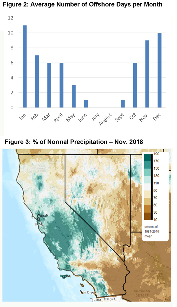
Near normal number of offshore wind events expected through December.
Near normal precipitation expected in December, but rain/snow possibly decreasing in January.
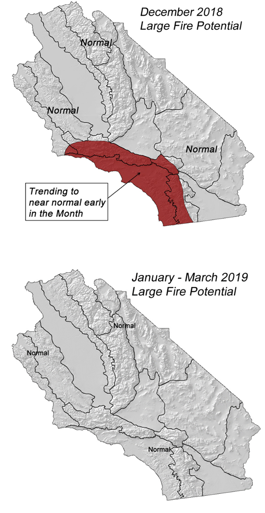
Large fire potential trending back to near normal early in December.
Weather Discussion
December 3, 2018 - November 2018 will long be remembered for the deadly, catastrophic wildfires which impacted both Northern and Southern California. Gusty north and northeast winds developed on the 8th across the entire state which lead to eruption of the deadliest and most costly wildfire in California history – the Camp Fire. On that same day, the Woolsey
 Fire broke out which rapidly tore through nearly 100,000 acres in and around the Santa Monica Mountains, forcing nearly 300,000 people to evacuate.
Wind speeds over Southern California on the 8th, while quite gusty, were not as strong overall as during the wind events of October or early July. There were some gusts approaching 60 mph, but most areas in the Santa Monica Mountains saw sustained wind speeds in the 20-40 mph range during the peak of the offshore wind event. However, minimum relative humidity readings were very low for several days with most locations seeing minimums in the 3-8% range. There was also little, if any, RH recovery at night which allowed for ideal drying conditions of all fuel types.
Even before the onset of the offshore winds, dead fuel moisture readings were close to record low readings. The streak of dry, windy weather further dried fuels causing fuel moisture to drop to the lowest levels recorded in 30- 40 years of record keeping. Therefore, the dryness of the fuels played perhaps an even bigger role than the offshore winds in generating the extreme fire behavior seen during the Woolsey Fire.
Fortunately, the strong ridge which had been stationary over the Eastern Pacific weakened and shifted southwest, which finally opened the door for a wetter and cooler pattern to enter the state. A strong storm system aided by a high amount of precipitable water brought widespread, significant wetting rains to the area at the end of November.
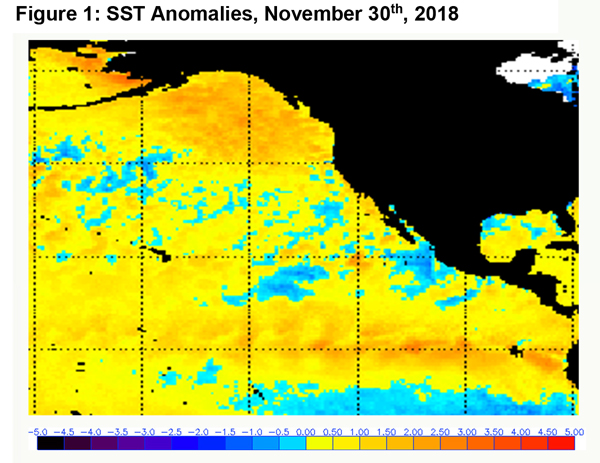
Even though the longwave weather pattern over the Western U.S. has changed radically as of late, the underlying ocean temperature regime has not changed much during the past month. Sea surface temperatures (SST) along the equatorial pacific remain locked in a 0.5 – 1.0° C above normal level but there has been a bit more warming in the Niño 3.4 region during the past month.
Most long range models indicate the wet weather pattern which began last month will continue into December, at least for the first part of the month. But the expansive area of above normal SST over the Gulf of Alaska remains in place. This along with a Pacific Decadal Oscillation (PDO) trending negative may lead to drier weather later this winter. Some of these same long range models indicate such a pattern change may occur in January, while other keep conditions wet until February, when a majority of models indicate a return of drier than normal weather.
Thus, unlike last year, there is no clear signal of whether this winter will be wetter or drier than normal. There will likely be pronounced changes between wet and dry periods, with the differences between the two perhaps being a bit more extreme than usual. Given the warm SST, temperatures should average a bit above normal this winter.
Local guidance depicts the number of offshore wind events may be closer to normal over the next month. Offshore wind events are usually more frequent in December than the fall months, but they may go more unnoticed, historically, due to their occurrence usually following a significant rainfall. (The average number of offshore wind events is actually highest in January.)
FUELS AND DROUGHT OUTLOOK
The widespread rain event of November 28th has altered the fuel landscape significantly in both the short and long term. For 6 of the past 8 winters, fuels have been far drier than normal at the start of December, at least over Southern California. But this year, the combination of wet weather and short daylight hours should result in an efficient uptake of subsoil moisture by live vegetation. There will likely be a vast greenup of seasonal grasses over the next few weeks while native brush begins to show some growth.
Dead fuels will likely remain too wet to allow for ignition through at least the first half of the month. No periods of significant drying is expected anytime soon, so these fuels will not support large fire growth until a prolonged period of warm, dry weather occurs.
Large fire potential will therefore fall to near normal over the next month and fire activity should remain at seasonally low levels (near zero) through at least January. A change to warmer and drier weather, should it occur, in the late winter into spring time period may lead to an earlier start to next year’s “fire season.” But until then, initial attack and resource demand should remain at seasonally low levels in December-- in stark contrast to several of the last few years.
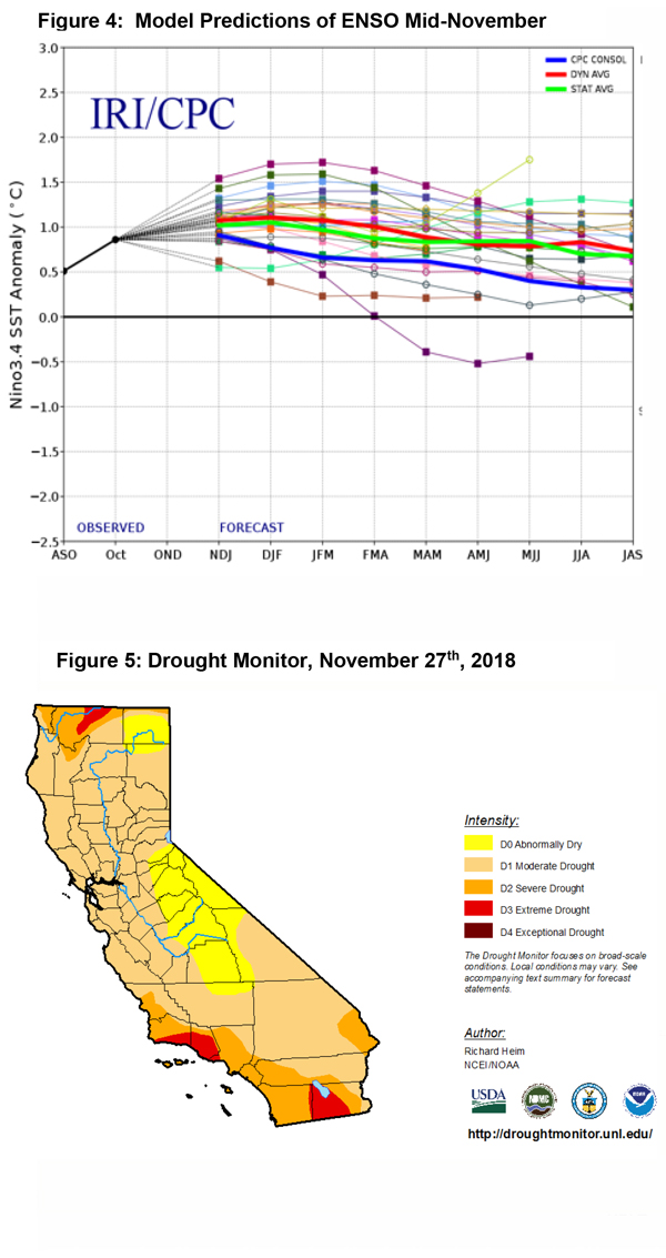
At the current time, much of the area remains in a D1 to D3 drought (the map on the left was produced prior to the storm of the 28th). Wet weather will likely go far to reducing the areas of extreme drought, but a D1 or perhaps a D2 drought may continue to occur over portions of the district the rest of the winter. Snowpack this winter may be a bit lower than normal this year which may lead to lower reservoir storage heading into spring. But compared to last year, both the fire and hydrological situation in California is much improved.
Source: Predictive Services

