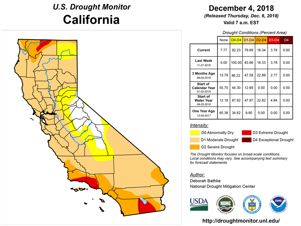
California and National Drought Summary for December 4, 2018
Summary
December 6, 2018 -Storms impacted much of the continental United States. The storm delivered heavy rain and mountain snow to the West, snow and wind to parts of the Plains and upper Midwest, and severe weather and tornadoes to the mid-Mississippi valley and Southeast coast. The precipitation with this storm brought improvements to drought areas in parts of the Sierra Nevada and Central Valley and helped to relieve long-term deficits in parts of the Intermountain West and Plains. With the exception of the Florida Peninsula, all remaining drought areas east of the Mississippi River have been eliminated. Degradations this week were limited to an expansion of abnormally dry conditions in Texas.
Northeast
Precipitation in the Northeast was near to slightly above normal for this time of year, with amounts ranging from about 0.5 to 2.5 inches. The region remains drought free, with small pockets of abnormally dry conditions in northern New York, Vermont, and Maine. The only change to this week’s map was a small reduction in the abnormally dry depiction in northern Maine, where recent precipitation has been enough to replenish moisture deficits.
Southeast
Much of the Southeast received an inch or more of precipitation last week. The heaviest rain, with totals of 5 to 10 inches, fell in a band stretching from the Florida Panhandle to the Georgia coast. This week’s rain improved short-term precipitation deficits, replenished soil moisture conditions, and alleviated moderate drought conditions in parts of Georgia, South Carolina, and northeast Florida.
South
Rainfall from this weekend’s storm affected parts of eastern Oklahoma, Arkansas, Mississippi, Tennessee, and Louisiana, which allowed for a slight reduction in moderate drought in northeast Oklahoma and northwest Arkansas. Other than this moderate drought area, no other changes to drought were made, and the region remained drought free with the exception of the Texas Panhandle and northeast Oklahoma.
Midwest
This week’s storm brought a mix of weather to the Midwest including rain, snow, and severe thunderstorms. The precipitation helped alleviate some of the lingering pockets abnormal dryness in Minnesota and Missouri.
High Plains
Moderate to heavy precipitation from this weekend’s storm, in the forms of rain and wind driven snow, fell roughly from the western reaches of the Dakotas to the northern half of Kansas. The precipitation allowed for the removal of moderate drought in east-central Kansas. While last week’s snowfall in the Dakotas was near normal for this time of year, long-term precipitation deficits have shown recovery, resulting in the removal of moderate drought in South Dakota and reductions in North Dakota. Moderate drought and abnormal dryness remain in those areas still experiencing low groundwater levels, soil moisture shortages, and long-term precipitation deficits.
West
Widespread rain and snow fell across the region over the past week. Heavy snowfall in the Sierra Nevada and precipitation in the Central Valley led to improvements in these areas. These changes were made in coordination with local experts and supported by improvements in a number of indicators, including precipitation indices, snow water equivalent, and soil moisture. The drought depiction in northern California was changed to “SL” as signals for drought are now apparent in both short and long term data. Recent precipitation in the Intermountain West improved current snowpack and long-term precipitation deficits, resulting in widespread improvements to long-term drought conditions in Utah, Colorado, and northeast Arizona.
Alaska, Hawaii, and Puerto Rico
After a solid start to the Hawaiian Islands’ wet season, conditions since mid-November have been dry across many of the west facing slopes in the state resulting in the introduction of D0 in these areas. Alaska and Puerto Rico remained unchanged on this week’s map. Below normal rainfall in Puerto Rico combined with spotty reports of low streamflow and groundwater data continue to support the depiction of D0 in the south central part of the Island. In Alaska, precipitation in the drought affected areas of the Panhandle was not enough to reduce the long-term deficits.
Looking Ahead
Over the next week, cold air is expected to remain entrenched across parts of the central and eastern United States. One storm system is forecast to traverse the southern US from late this week through the weekend. With ample amounts of moisture available, the National Weather Service quantitative precipitation forecast calls for moderate to heavy precipitation in the form of rain, snow, and some areas of a wintry mix from parts of the Southern Plains eastward into the Southeast. Elsewhere, another storm system is expected to move in from the Pacific early next week, bringing additional precipitation to the west coast states. In between these two storm systems, a ridge in the jet stream will deliver dry conditions to the Plains and Midwest.
Author(s):
Deborah Bathke, National Drought Mitigation Center
Dryness Categories
D0 Abnormally Dry—used for areas showing dryness but not yet in drought, or for areas recovering from drought.
Drought Intensity Categories
D1 Moderate Drought
D2 Severe Drought
D3 Extreme Drought
D4 Exceptional Drought
Drought or Dryness Types
S Short-Term, typically less than 6 months (e.g. agricultural, grasslands)
L Long-Term, typically greater than 6 months (e.g. hydrologic, ecologic)
Source: National Drought Mitigation Center


