


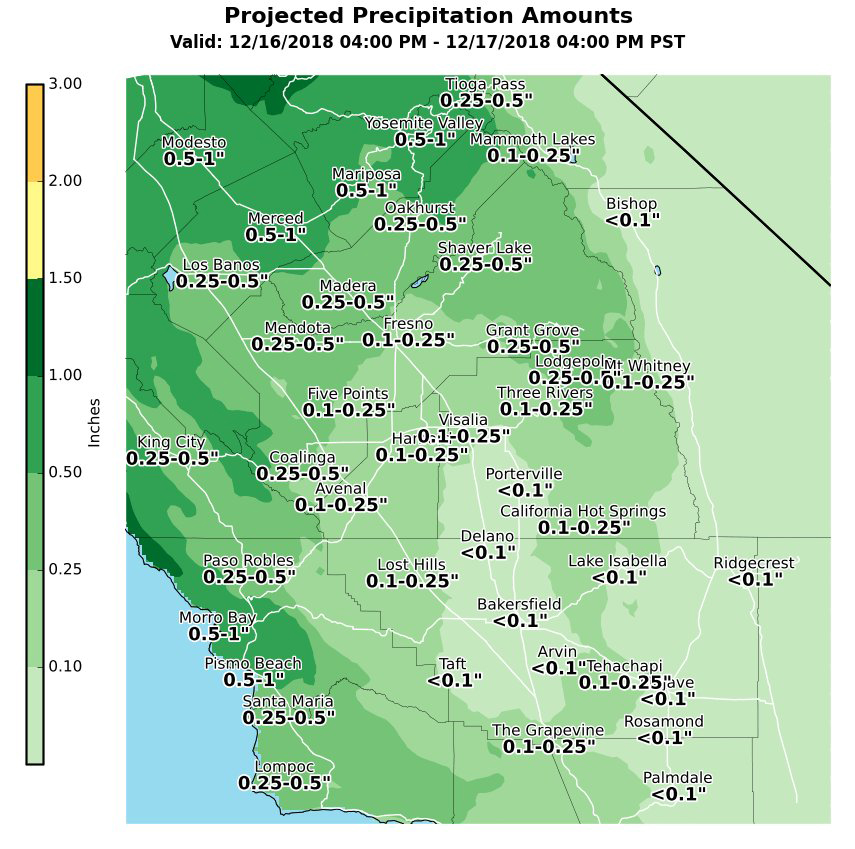
December 15, 2018 - The National Weather Service Hanford office projected precipitation amounts for Sunday evening through Monday afternoon ahead of and along an approaching cold front.
  Area Forecast Discussion
  National Weather Service San Joaquin Valley - Hanford CA
  321 AM PST Sat Dec 15 2018

  .SYNOPSIS...
  Dry weather will persist today through Sunday morning. A cold
  front will approach California Sunday afternoon. This cold front
  will be responsible for valley rain and mountain snow Sunday night
  and Monday. Dry weather will return to Central California Monday
  night and persist through at least Friday.

  &&

  .DISCUSSION...
  An upper-level ridge of high pressure will be located over the
  Pacific Northwest today. This ridge of high pressure aloft will
  amplify as it moves eastward tonight and Sunday morning. A cold
  front will approach the California coastline Sunday afternoon.
  This cold front will move eastward through Central California
  Sunday night into Monday morning. Rain amounts should vary from
  just under one tenth of an inch in the southern portion of the San
  Joaquin Valley to around one half of an inch in the northern
  portion of the San Joaquin Valley, with slightly higher values in
  the foothills. Ferguson burn scar flooding is possible Sunday
  night and Monday morning. Rain should turn to snow around 6,000
  feet. A Winter Weather Advisory may be required for the Sierra
  Nevada from Yosemite to Kings Canyon for Sunday night and Monday
  morning. Due to the marginal nature of this event, a Winter
  Weather Advisory will not be issued at this time.

  The aforementioned cold front will move eastward through the
  Great Basin Monday afternoon and Monday night. An upper-level area
  of high pressure will be centered near latitude 30 North,
  longitude 120 West Tuesday through at least Thursday. A weak
  trough of low pressure aloft may pass through Central California
  Thursday night or Friday. Dry weather is expected Monday night
  through at least Friday, with late night and early morning Tule
  Fog a distinct possibility.
Source: NWS

