


January 3, 2019 - The National Weather Service Hanford Office reports a storm will bring snow and wintry travel conditions above 4,500 feet in the Sierra this coming weekend.
Motorists should anticipate lengthy delays and slick, potentially hazardous road conditions and possible road closures above 4,500 feet.
If traveling consider alternate plans, remember to carry tire chains, extra food, water, and clothing.
Campers and hikers should be prepared for hazardous winter-like conditions.
For information on road conditions, including possible closures or delays, call Caltrans at 1-800-427-7623 or visit http://www.dot.ca.gov/cgi-bin/roads.cgi.
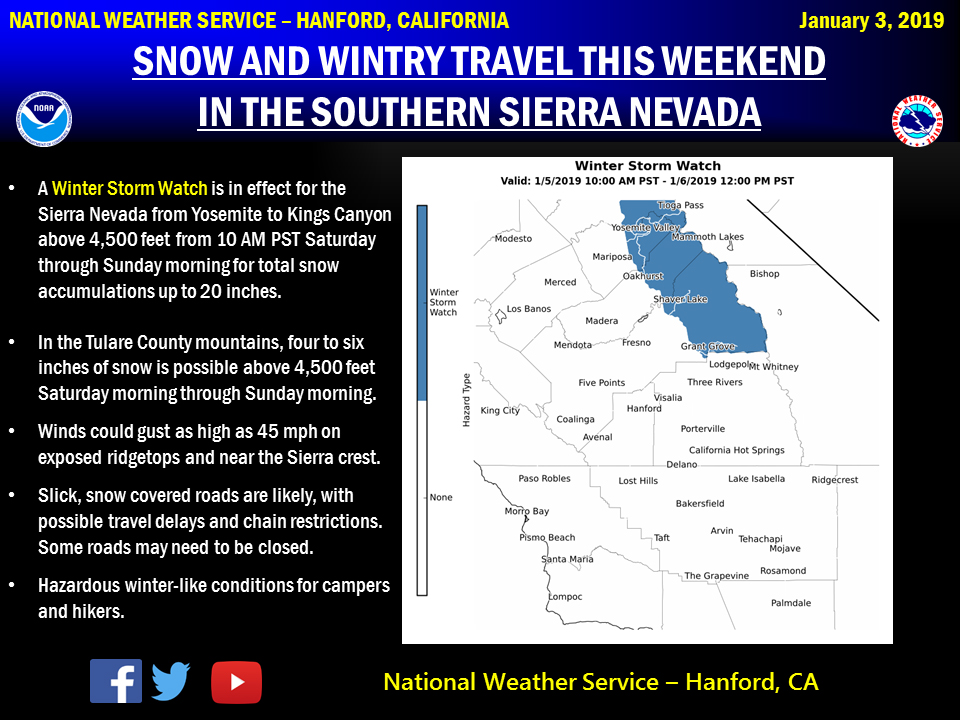
Winter Storm Watch
URGENT - WINTER WEATHER MESSAGE
National Weather Service Hanford CA
447 AM PST Thu Jan 3 2019

Sierra Nevada from Yosemite to Kings Canyon-
447 AM PST Thu Jan 3 2019

...A WINTER STORM WATCH REMAINS IN EFFECT FOR SATURDAY MORNING
THROUGH SUNDAY MORNING...

* WHAT...Heavy snow possible. Total snow accumulations of up to 20
  inches conceivable. Winds could gust as high as 45 mph on
  exposed ridgetops and near the Sierra crest.

* WHERE...Sierra Nevada from Yosemite to Kings Canyon above 4,500
  feet.

* WHEN...From Saturday morning through Sunday morning.

* ADDITIONAL DETAILS...Travel could be very difficult to
  impossible. Gusty winds may bring down tree branches.

PRECAUTIONARY/PREPAREDNESS ACTIONS...

A Winter Storm Watch means there is potential for significant
snow, sleet, or ice accumulations that may impact travel. Continue
to monitor the latest forecasts.
Source: NWS

