


Mariposa rainfall forecast for possible rainfall totals as of Monday at 4:00 A.M.
Tue.: 80% chance of rain with up to .75" possible.
Wed.: 50% chance of showers increasing to 90% during the evening hours with up to 2.50" possible.
Thu.: 100% chance of rain with up to 2.50" possible.
Fri.: 40% chance of showers.
Sun.: 20% chance of showers
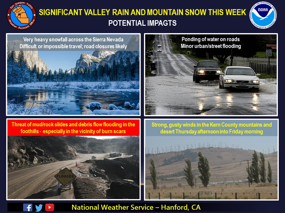
January 14, 2019 - The National Weather Service Hanford Office reports a series of potent storm systems will impact Central California Tuesday through Thursday night, resulting in a variety of impacts.
A Winter Storm Watch will likely be required for the Southern Sierra Nevada above 5,000 feet.
A Flood Watch may be required for the foothills.
Hydrologic Outlook
HYDROLOGIC OUTLOOK
National Weather Service HANFORD CA
205 AM PST Mon Jan 14 2019

...HEAVY RAINFALL AND A THREAT OF FLOODING IS LIKELY WEDNESDAY
EVENING THROUGH THURSDAY IN THE SIERRA FOOTHILLS AND THE SIERRA
NEVADA BELOW 7000 FEET...

A Pacific storm system will bring an abundance of precipitation
into mainly the higher elevations north of Kern County during
midweek. Heavy rain from this storm could result in flash
flooding, washed out roads, mud slides, rock slides and debris
flows, particularly in the vicinity of the burn scars. Flooding
is also possible near and along rivers and streams in the Sierra
foothills Wednesday night through Thursday. Rain totals of 2 to
4 inches could occur in this region by Thursday evening.

In the Sierra above 7,000 feet, heavy snow accumulations and
hazardous winter travel is likely during mid to late week where up
to 4 feet of new snow is possible.

Residents in the foothills and higher elevations of the Sierra
should be prepared for the possibility of life threatening
flooding and closely monitor the latest National Weather Service
forecasts this week for Flash Flood Watches and Warnings. If you
live in a flood prone area, this would be a good time to review
an emergency escape plan in the event high water or a debris flow
threatens your home. Burn scars that might be impacted by heavy
rain include the Ferguson burn scar, Railroad burn scar and the
Pier burn scar.
  Area Forecast Discussion
  National Weather Service San Joaquin Valley - Hanford CA
  340 AM PST Mon Jan 14 2019

  .SYNOPSIS...
  A Weak trough will
  bring light precipitation across CENCAL interior later today and
  this evening. Rain and snow will return on Tuesday afternoon and
  evening. Some clearing on Wednesday before a very strong storm
  system moves in late Wednesday night and continues through
  Thursday. Clearing Friday through Sunday. Weather system moves
  through the region on Sunday night and Monday with more rain and
  high elevation snow.


  .DISCUSSION...
  The low off the
  CENCAL coast will push a trough north through CENCAL later today
  with a few showers possible mainly Fresno county northward. Rain
  will be light in the valley, with some higher QPF amounts in the
  Sierra, north of Tulare county. Snow level will remain around 5000
  today and briefly lower to around 4500 tonight across the Sierra.
  Up to 4 inches is possible above 5000 feet.

  We will see a brief break in the action during the day on
  Wednesday as short wave ridging builds in over the area in advance
  of a very strong Atmospheric River event starting late Wednesday
  evening and continuing through Thursday. Models are coming around
  with better agreement in timing and intensity with the event.
  This AR event will be quite impressive as deep subtropical
  moisture will be entrained into the strong cold front expected to
  move through on Thursday. Rainfall amounts below the snow line
  will be 2 to 4 inches and snow will be up to 4 feet above 7000
  feet. The snow level will rise during the event, which is
  expected during an AR event. The frontal boundary is expected to
  be through CENCAL by late Thursday with high pressure returning
  for Friday and continuing through Sunday evening. Patchy fog is
  possible in the SJV Saturday and Sunday mornings. Another cold
  front will quickly move through the region Sunday night and Monday
  morning with more rain and high elevation snow possible.
Source: NWS

