


California and National Drought Summary for January 22, 2019
Summary
January 24, 2019 - An active pattern has continued with general ridging over the West and a trough digging in through the central and eastern United States. During the past week, a strong surface low developed in the Southwest and tracked through the central Plains into the Midwest and finally the Northeast. Abundant precipitation was recorded and snow totals in the Rocky Mountains were good. With the cold air dropping in behind these storms, most of the eastern half of the country has remained colder than normal while the West has been warmer than normal.
Northeast
Temperatures were below normal for the week with most of the region recording temperatures that were 3-6 degrees below normal. The coldest areas were in northern New York and into Maine. It was a wet week, with most of the region having above-normal precipitation with departures of close to an inch above normal. With no issues of dryness in the region, the abnormally dry conditions were removed from Vermont and Maine this week.
Southeast
Cooler than normal temperatures were also recorded over the Southeast, with departures of 3-6 degrees below normal widespread throughout the region. Near-normal temperatures were recorded in Mississippi, Georgia and South Carolina. Precipitation was mixed in the region with portions of Tennessee, Virginia, and North Carolina and the northern portions of Mississippi, Alabama, and Georgia all having above-normal precipitation. Portions of Tennessee recorded 1-2 inches above normal precipitation for the week. It was dry along the Gulf Coasts of Mississippi, Alabama and into Florida where areas were up to an inch below normal for the week. Rains over southern Florida prevented any expansion of drought in that region for the week.
Midwest
Cold temperatures dominated the Midwest for the week, with most areas 6-9 degrees below normal for the week. The coldest temperatures were in the northern reaches of the Midwest, where portions of northern Minnesota were 15 degrees below normal for the week. Precipitation was limited to those areas along the storm track of the most recent weather event. Portions of Kentucky, Ohio, Indiana, and Missouri were above normal for precipitation this week, with departures of up to an inch above normal in Kentucky. Portions of Iowa, Minnesota, and Wisconsin also had above-normal precipitation with departures of up to 0.50 inches above normal. There is no current drought in the Midwest, and no issues are developing.
High Plains
Temperatures were mixed in the region, with the eastern portions of the region recording temperatures up to 12 degrees below normal while the western portions were 3-6 degrees above normal. With an active storm pattern, much of the region recorded precipitation, with the greatest amounts over the plains of Colorado, North Dakota and South Dakota. Because of the pockets of dryness still over portions of eastern Colorado and the Dakotas’ mainly being long-term issues, no changes were made this week.
South
Warmer than normal temperatures dominated the region with departures in west Texas 6-9 degrees above normal. It was a mainly dry week over the area, with just portions of eastern Oklahoma, Arkansas and into Louisiana recording above-normal precipitation with departures of up to 0.50 inches above normal. With the continued dryness in south Texas, some new areas of abnormally dry conditions were added this week with an expansion of moderate drought in far south Texas.
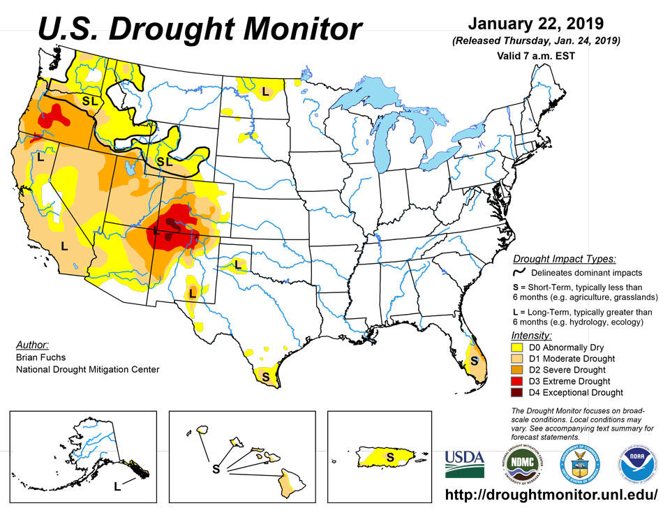
West
Much of the West recorded above-normal temperatures for the week with most areas 2-6 degrees above normal. The warmest temperatures were in eastern Oregon, southern Idaho, and eastern New Mexico, with departures of 6-8 degrees above normal. It was a wet week over the region as most areas recorded above-normal precipitation. The wettest conditions were in northern California and into southwest Oregon, where departures were 4-6 inches above normal. The higher elevations also received ample snow, with most SNOTEL locations in a normal to above-normal range. The exception to this is in western Oregon and Washington, where snow is still lagging. The basins that have the greatest snow water equivalent (SWE) values for this time of year are in Colorado, Utah, Nevada, Arizona and New Mexico.
Widespread improvements were made to the exceptional and extreme drought conditions in the Four Corners regions this week. In the short term, snowpack is steadily building and indicators are showing improvement. How these short-term improvements manifest into relief from long-term impacts remains uncertain until the spring snowmelt season begins. There are still many impacts being experienced and even though improvements were shown, this drought situation is still quite serious, with large hydrologic deficits and major ecological damage which will take much longer to recover from.
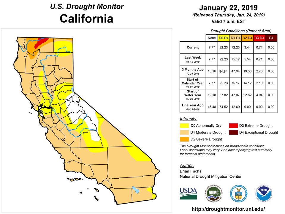
Improvements were made to the severe drought conditions in Utah and into western Colorado. Farther south, moderate drought was improved in Arizona, southern Nevada, and southwest Utah. Severe drought conditions were removed from western Arizona and southern California as well as the coastal regions of southern California. In the north, the eastern portions of both Oregon and Washington have had good precipitation and enough to show improvements to the extreme drought in eastern Oregon and the moderate drought and abnormally dry conditions over eastern Washington.
Alaska, Hawaii, and Puerto Rico
No changes were made to Alaska, Hawaii, or Puerto Rico this week. In Puerto Rico, two reservoirs are being monitored where moderate drought is already in place.
Looking Ahead
Over the next 5-7 days, the eastern United States has the greatest potential for precipitation, with the greatest amounts over the Southeast and into southern Florida. The northern United States also should see precipitation from the northern Rocky Mountains into the Great Lakes and New England. Temperatures look to remain colder than normal over the Midwest with departures of high temperatures of up to 20 degrees below normal. Warmer than normal conditions are expected over the West with high temperatures 3-6 degrees above normal.
The 6-10 day outlooks show that temperatures are likely to remain colder than normal over most areas east of the Rocky Mountains, with the greatest likelihood of below-normal temperatures over the Great Lakes and Tennessee Valley regions. Areas along the west coast and also in Alaska are anticipated to have the best chances of above-normal temperatures. The highest probability of below-normal precipitation is along the west coast and into the Southwest and southern Plains while Alaska, the northern Plains and much of the coastal areas of the East have the greatest chances of above-normal precipitation.
Author(s):
Brian Fuchs, National Drought Mitigation Center
Dryness Categories
D0 Abnormally Dry—used for areas showing dryness but not yet in drought, or for areas recovering from drought.
Drought Intensity Categories
D1 Moderate Drought
D2 Severe Drought
D3 Extreme Drought
D4 Exceptional Drought
Drought or Dryness Types
S Short-Term, typically less than 6 months (e.g. agricultural, grasslands)
L Long-Term, typically greater than 6 months (e.g. hydrologic, ecologic)
Source: National Drought Mitigation Center

