


California and National Drought Summary for January 29, 2019
Summary
January 31, 2019 - Colder than normal temperatures dominated most of the United States for the week, especially areas east of the continental divide. The eastern half of the country remained quite wet, with most areas east of the Missouri River recording above-normal precipitation for the week. The cold settled in as a polar vortex descended south and arctic air blasted the Midwest, Great Lakes and portions of the Plains at the end of the current period.
Northeast
Temperatures were mixed during the week; coastal areas were normal to slightly above normal while portions of New York and Pennsylvania were normal to slightly below normal. The region was wet from the impact of a winter storm that tracked through the region. Most areas were 0.50 to 1.50 inches above normal precipitation for the week. No drought issues are being observed in the region.
Southeast
Most areas were cooler than normal for this week, with departures of up to 3 degrees below normal observed throughout the region. Almost the entire region received ample precipitation for the week, with areas of Florida recording close to 4 inches above normal. The ample rain in south Florida allowed for a full category improvement to the drought status this week where severe drought was eliminated and moderate drought was confined to the coastal regions of east Florida.
Midwest
Cold temperatures dominated the region. Areas of the upper Midwest were 15-20 degrees below normal for the week while southern areas were 5-10 degrees below normal. Ample precipitation was recorded over most of the region, with areas of Illinois, Indiana, and Ohio at over an inch above normal for the week. No drought issues are being observed in the region.
High Plains
The colder than normal temperatures were also impacting most of the High Plains, where temperatures were about 5 degrees below normal over most areas. The region was mostly drier than normal for the week, with only areas of the Dakotas, southeast Nebraska, and eastern portions of Colorado and Wyoming receiving slightly above normal precipitation. The conditions did not warrant any changes to the drought status this week in the pockets of remaining drought in North Dakota and eastern Colorado.
South
The colder than normal temperatures made their way into the South, with most of the region having temperatures 3-6 degrees below normal for the week. Most of the region was dry, but above-normal precipitation was recorded from southern Texas up into Louisiana and Arkansas, with departures of up to 1.50 inches above normal for the week. The rains in southern Texas did allow for some improvement to the drought status there, but abnormally dry conditions were expanded in other portions of southern Texas as well as farther north in the panhandle.
West
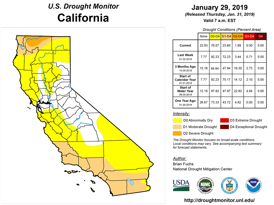
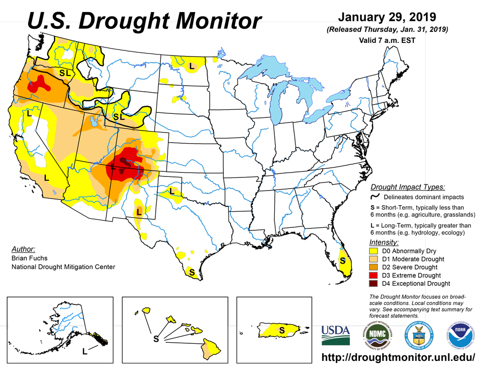
Temperatures were mixed in the region as they were below normal through the Rocky Mountains and above normal through the rest of the region. It was a mainly dry week over much of the West with only areas of the central and northern Rocky Mountains into the Great Basin recording above-normal precipitation. The driest conditions were along the coastal areas of Washington, Oregon, and California, where departures were 1-2 inches below normal. Even with a dry week, a reassessment of conditions was done, which allowed for quite a few improvements over California, Nevada, Utah, Arizona, Colorado, and Oregon. In most of California, a full category improvement was done in response to the short-term indicators. Nevada had conditions improve by a full category in both the eastern and western portions of the state. In Utah, severe drought was improved in the northern portions of the state while in Oregon, extreme drought was eliminated from the southern part of the state. Severe drought conditions were eliminated from the western part of Arizona while conditions improved over north-central and northeastern Colorado. Moderate drought was expanded in central Idaho where the upper elevation snow accumulation has been lagging and dry conditions have been developing over the last 6 months.
Alaska, Hawaii, and Puerto Rico
Most areas of Hawaii were normal to below normal for temperatures this week, and in response to an El Niño-like weather pattern, dryness has continued to develop across the state. Abnormally dry conditions were expanded to cover the entire state while severe drought was introduced on Maui and expanded on the Big Island and moderate drought was expanded on the Big Island and Kauai. No changes were made in Alaska and Puerto Rico this week, but several reservoirs were being monitored in Puerto Rico as dryness continues across the island.
Looking Ahead
Over the next 5-7 days, there will continue to be an active storm track across the country where a significant storm will impact the West coast and into the intermountain West and Southwest, bringing the chance for significant precipitation. The eastern half of the United States will also have good chances of widespread precipitation, with the greatest amounts over the Tennessee valley and lower Mississippi basin. High temperatures during this period look to be warmer than normal, with the warmest highs over the central Plains and South with departures of 9-12 degrees above normal. Cooler temperatures will impact the West coast and New England with departures of 3-6 degrees below normal.
The 6-10 day outlooks show that almost the entire country is showing above-normal chances of above-normal precipitation, with the greatest probabilities over the Midwest and into New England. A few areas are projected to have above-normal chances of below-normal precipitation, including the Florida peninsula and portions of northern California and into the Pacific Northwest. The greatest probability of above-normal temperatures is over the eastern third of the United States and into Texas as well as in Alaska. The West and High Plains have the greatest probabilities of below-normal temperatures, with the greatest chances over North Dakota, South Dakota, Montana and portions of northern Wyoming and Idaho.
Author(s):
Brian Fuchs, National Drought Mitigation Center
Dryness Categories
D0 Abnormally Dry—used for areas showing dryness but not yet in drought, or for areas recovering from drought.
Drought Intensity Categories
D1 Moderate Drought
D2 Severe Drought
D3 Extreme Drought
D4 Exceptional Drought
Drought or Dryness Types
S Short-Term, typically less than 6 months (e.g. agricultural, grasslands)
L Long-Term, typically greater than 6 months (e.g. hydrologic, ecologic)
Source: National Drought Mitigation Center

