


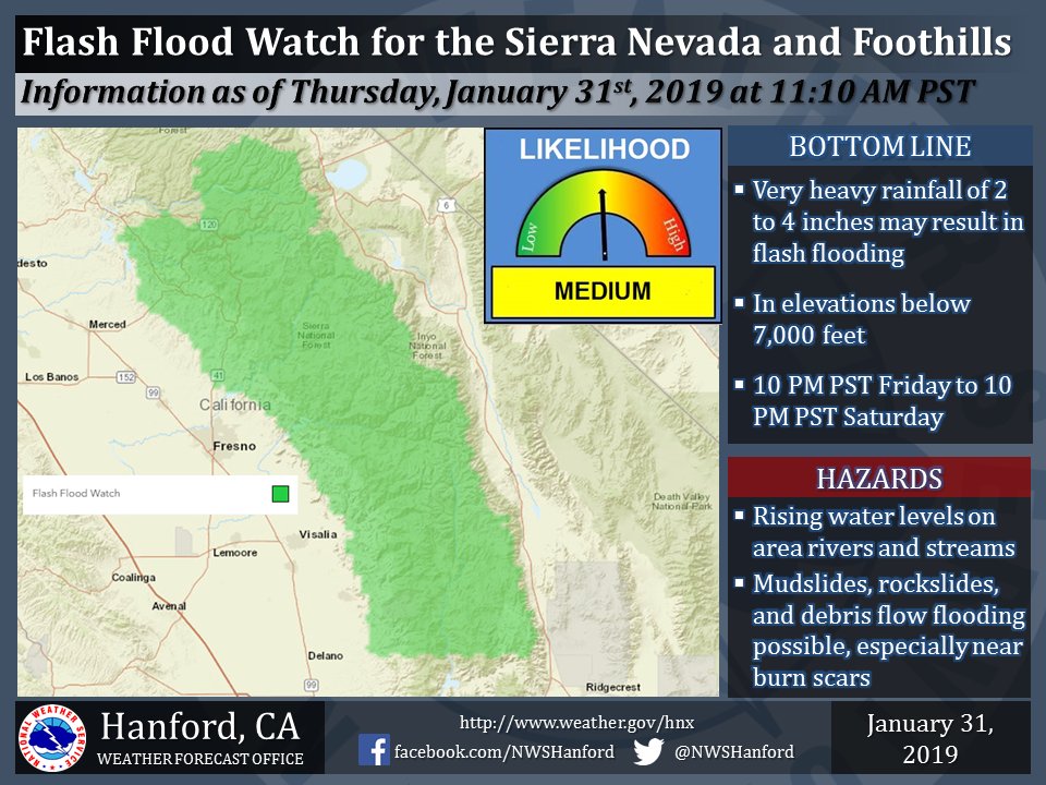
January 31, 2019 - The National Weather Service Hanford Office reports a Flash Flood Watch has been issued for the Mariposa, Madera, and Fresno County Foothills - Tulare County Foothills - Sierra Nevada from Yosemite to Kings Canyon- Tulare County Mountains- Including the cities of Coarsegold, Oakhurst, Squaw Valley, Auberry, North Fork, Mariposa, Springville, Three Rivers, Devils Postpile, Florence Lake, Lake Thomas Edison, Tuolumne Meadows, Bass Lake, Fish Camp, Wawona, Camp Nelson, Giant Forest, Lodgepole, Grant Grove, and Johnsondale.
Beginning Friday Evening through Saturday Evening.
Heavy rain totaling from 2 to as much as 4 inches may lead to excessive runoff, rising water levels on area rivers and streams and a threat of flash flooding. Additionally, mud slides, rock slides and debris flows are possible in some locations, especially in the vicinity of the Ferguson, Railroad and Pier burn scars. Some roads may become closed, impassable, or washed out.
Flash Flood Watch
Flood Watch
National Weather Service Hanford CA
1045 AM PST Thu Jan 31 2019


Mariposa, Madera, and Fresno County Foothills-
Tulare County Foothills-
Sierra Nevada from Yosemite to Kings Canyon-
Tulare County Mountains-
Including the cities of Coarsegold, Oakhurst, Squaw Valley,
Auberry, North Fork, Mariposa, Springville, Three Rivers,
Devils Postpile, Florence Lake, Lake Thomas Edison,
Tuolumne Meadows, Bass Lake, Fish Camp, Wawona, Camp Nelson,
Giant Forest, Lodgepole, Grant Grove, and Johnsondale
1045 AM PST Thu Jan 31 2019

...FLASH FLOOD WATCH IN EFFECT FROM FRIDAY EVENING THROUGH
SATURDAY EVENING FOR THE SIERRA FOOTHILLS AND THE SIERRA NEVADA
BELOW 7000 FEET...

The National Weather Service in Hanford has issued a

* Flash Flood Watch for a portion of central California,
  including the following areas, Mariposa, Madera, and Fresno
  County Foothills, Sierra Nevada from Yosemite to Kings Canyon,
  Tulare County Foothills, and Tulare County Mountains.

* From Friday evening through Saturday evening

* Heavy rain totaling from 2 to as much as 4 inches may lead to
  excessive runoff, rising water levels on area rivers and streams
  and a threat of flash flooding. Additionally, mud slides, rock
  slides and debris flows are possible in some locations,
  especially in the vicinity of the Ferguson, Railroad and Pier
  burn scars. Some roads may become closed, impassable, or washed
  out.

PRECAUTIONARY/PREPAREDNESS ACTIONS...

A Flash Flood Watch means that conditions may develop that lead
to flash flooding. Flash flooding is a VERY DANGEROUS SITUATION.

You should monitor later forecasts and be prepared to take action
should Flash Flood Warnings be issued. If you live in a flood prone
area, this would be a good time to review an emergency escape plan
in the event high water or a debris flow threatens your home.
Source: NWS

