


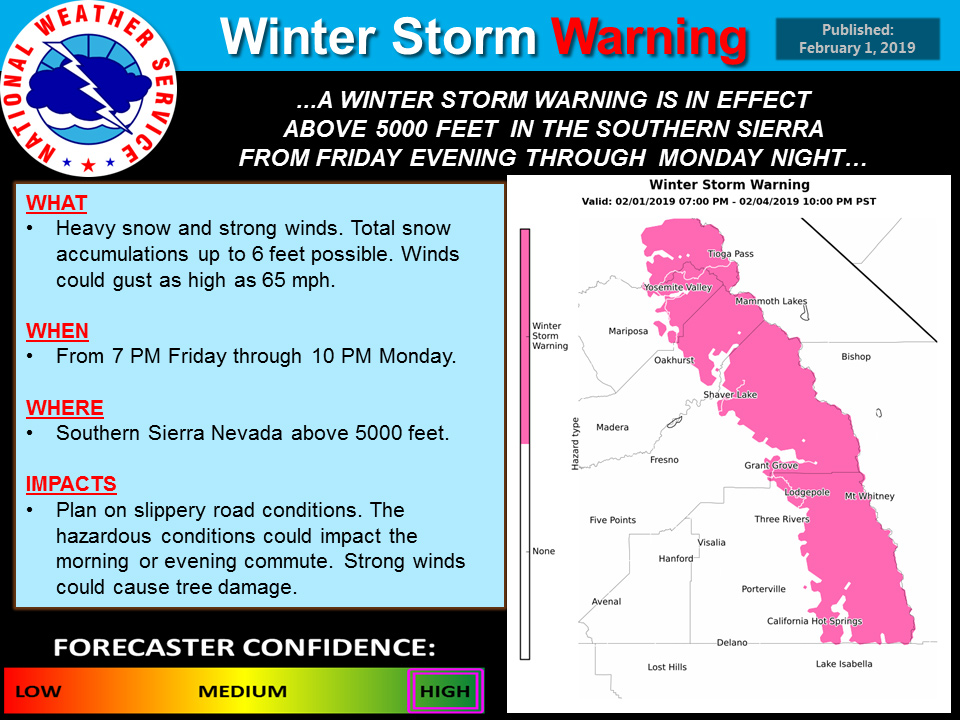
February 1, 2019 - The National Weather Service Hanford Office reports heavy snow is expected to start this evening and continue through Monday night as two separate storm systems will move across the Southern Sierra Nevada.
Snow levels will start out around 7000 feet and lower on Saturday night to around 5000 feet.
There will be a brief break on Sunday morning before the next system moves in Sunday afternoon and evening.
Snow levels will once again lower to 3500 to 4000 feet Sunday night and Monday.
Total snow amounts could be as high as six feet at the higher elevations.
Winter Storm Warning
URGENT - WINTER WEATHER MESSAGE
National Weather Service Hanford CA
254 AM PST Fri Feb 1 2019


Sierra Nevada from Yosemite to Kings Canyon-
Tulare County Mountains-
Including the cities of Camp Nelson, Giant Forest, and Lodgepole
254 AM PST Fri Feb 1 2019

...WINTER STORM WARNING IN EFFECT FROM 7 PM THIS EVENING TO 10 PM
PST MONDAY ABOVE 5000 FEET...

* WHAT...Heavy snow above 5000 feet. Total snow accumulations
  through the weekend up to 6 feet. Winds could gust as high as 65
  mph along the crest. Snow levels will start out this evening
  around 7000 feet and drop to around 5000 Saturday night. Snow
  levels will drop below 4000 feet Sunday night and Monday.

* WHERE...Sierra Nevada from Yosemite to Kings Canyon and Tulare
  County Mountains.

* WHEN...From 7 PM this evening to 10 PM PST Monday.

* ADDITIONAL DETAILS...Travel could be very difficult to
  impossible. The hazardous conditions could impact the morning
  or evening commute. Very strong winds could cause extensive
  damage to trees and power lines.

PRECAUTIONARY/PREPAREDNESS ACTIONS...

A Winter Storm Warning means significant amounts of snow, sleet
and ice will make travel very hazardous or impossible.

The latest road conditions for the state you are calling from can
be obtained by calling 5 1 1.
Source: NWS

