


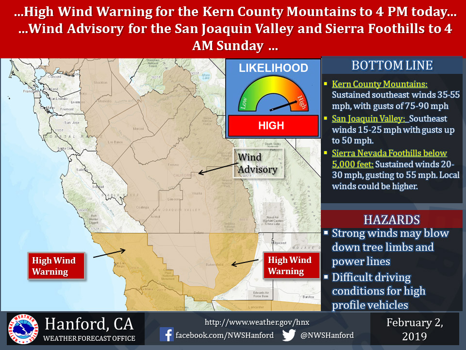
February 2, 2019 - The National Weather Service Hanford Office reports a High Wind Warning is in effect for the Kern County Mountains through 4:00 PM today and a Wind Advisory is in effect for San Joaquin Valley and Sierra Nevada Foothills below 5,000 feet through 4:00 AM Sunday.
The highest winds are expected below the Kern County mountain passes, including the Grapevine, as well as along the west side of the San Joaquin Valley early Saturday morning. Strong, gusty southeasterly winds may blow down trees, tree limbs, and power lines.
Power outages are possible.
Winds will increase again in the valley tonight after a brief reprieve in the afternoon.
Wind Advisory
URGENT - WEATHER MESSAGE
National Weather Service Hanford CA
851 AM PST Sat Feb 2 2019


Mariposa, Madera, and Fresno County Foothills-
Tulare County Foothills-
Sierra Nevada from Yosemite to Kings Canyon-
Tulare County Mountains-
Including the cities of Oakhurst, Mariposa, Springville,
Three Rivers, and Johnsondale
851 AM PST Sat Feb 2 2019

...WIND ADVISORY IN EFFECT UNTIL 4 AM PST SUNDAY BELOW
5000 FEET...

The National Weather Service in Hanford has issued a Wind
Advisory below 5000 feet, which is in effect until 4 AM PST
Sunday.

* WINDS...South 20 to 30 mph with gusts to 55 mph. A few locations
  could see gusts over 65 mph through mid morning.

* TIMING...Winds are expected to peak this morning before
  diminishing later this afternoon. Winds will increase again
  overnight.

* IMPACTS...Strong winds may blow down limbs, trees, and power
  lines. Scattered power outages are expected.

PRECAUTIONARY/PREPAREDNESS ACTIONS...

A Wind Advisory means that winds of 35 mph are expected. Winds
this strong can make driving difficult, especially for high
profile vehicles. Use extra caution.
Source: NWS

