


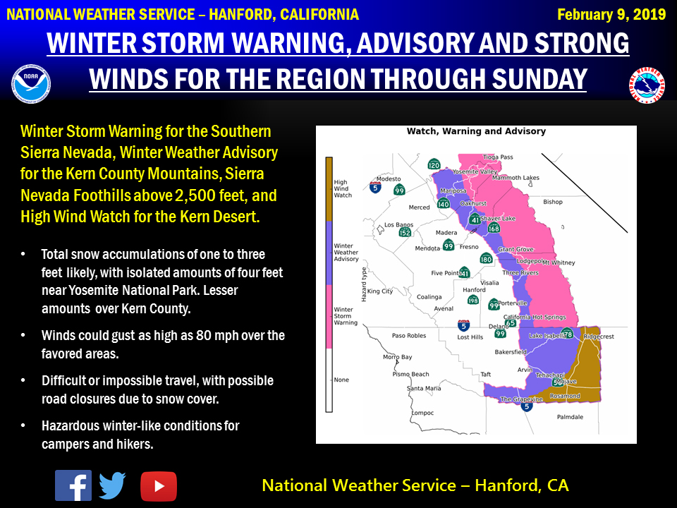
February 9, 2019 - The National Weather Service Hanford Office reports a couple of storm systems will impact Central California this weekend.
As a result, Winter Storm Warnings, Winter Weather and Wind Advisories are in effect for the Southern Sierra Nevada, the Kern County Mountains and Deserts from this evening through late Sunday night.
Snow levels should be 3,000 to 4,000 feet, so a few inches of accumulating snow is possible in the Southern Sierra Nevada foothills and near the Grapevine.
Winter Weather Advisory in the foothills above 2,500 feet Saturday night through Sunday morning.
Winter Weather Advisory
URGENT - WINTER WEATHER MESSAGE
National Weather Service Hanford CA
808 AM PST Sat Feb 9 2019

Mariposa, Madera, and Fresno County Foothills-
Tulare County Foothills-
Including the cities of Oakhurst, Mariposa, Springville,
and Three Rivers
808 AM PST Sat Feb 9 2019

...WINTER WEATHER ADVISORY IN EFFECT FROM 7 PM THIS EVENING TO
NOON PST SUNDAY ABOVE 2500 FEET...

* WHAT...Snow expected. Total snow accumulations of up to 7
  inches expected.

* WHERE...Mariposa, Madera, and Fresno County Foothills and
  Tulare County Foothills.

* WHEN...From 7 PM this evening to noon PST Sunday.

* ADDITIONAL DETAILS...Travel could be very difficult.

PRECAUTIONARY/PREPAREDNESS ACTIONS...

A Winter Weather Advisory for snow means periods of snow will
cause primarily travel difficulties. Expect snow covered roads
and limited visibilities, and use caution while driving.

The latest road conditions for the state you are calling from can
be obtained by calling 5 1 1.
Winter Storm Warning
URGENT - WINTER WEATHER MESSAGE
National Weather Service Hanford CA
808 AM PST Sat Feb 9 2019

Sierra Nevada from Yosemite to Kings Canyon-
Tulare County Mountains-
Including the cities of Camp Nelson, Giant Forest, Lodgepole,
and Johnsondale
808 AM PST Sat Feb 9 2019

...WINTER STORM WARNING REMAINS IN EFFECT UNTIL 4 AM PST MONDAY...

* WHAT...Heavy snow expected. Total snow accumulations of one to
  three feet likely, with isolated amounts of four feet near
  Yosemite National Park. A few inches of snow is possible in
  elevations between 3,000 and 4,000 feet. Winds could gust as
  high as 65 mph on exposed ridgetops and near the crest.

* WHERE...Sierra Nevada from Yosemite to Kings Canyon and Tulare
  County mountains.

* WHEN...Until 4 AM PST Monday.

* ADDITIONAL DETAILS...Travel could be very difficult to
  impossible. Strong winds could cause tree damage. The cold
  wind chills as low as 30 below zero could cause frostbite on
  exposed skin in as little as 30 minutes.

PRECAUTIONARY/PREPAREDNESS ACTIONS...

A Winter Storm Warning for snow means severe winter weather
conditions will make travel very hazardous or impossible. If you
must travel, keep an extra flashlight, food and water in your
vehicle in case of an emergency.

The latest road conditions for the state you are calling from can
be obtained by calling 5 1 1.
Source: NWS

