


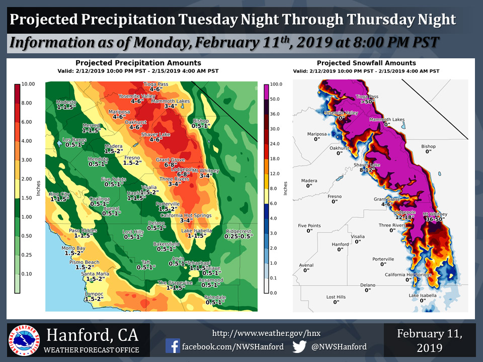
Mariposa could receive up to 6.00" of rain
Oakhurst could receive up to 6.00" of rain
Yosemite Valley could receive up to 6.00"of rain
February 12, 2019 - The National Weather Service Hanford Office reports with the incoming weather system the vast majority of this precipitation will fall Wednesday afternoon through Thursday morning.
A Winter Storm Watch is in effect for the higher terrain of the Southern Sierra Nevada.
A Flood Watch is in effect for elevations below 5,000 feet.
The Southern Sierra Nevada foothills are most susceptible to flooding.
Area Forecast Discussion
  National Weather Service San Joaquin Valley - Hanford CA
  246 AM PST Tue Feb 12 2019

  .SYNOPSIS...The next in a series of winter storms will move into
  the area tonight through Friday with heavy precipitation and gusty
  winds.

  &&

  .DISCUSSION...Just a few high clouds noted streaming into the
  forecast area early this morning however out over the Pacific a
  major rain and snow producing weather system is taking shape.
  Meanwhile in the mainly clear skies, freezing temperatures are
  already occuring in colder locations and the freeze warning will
  continue through the early morning.

  There are three main players in the very wet and stormy
  forecast...first the deep moisture plume stretching from just off
  the California coast out to south of Hawaii. Second the very
  persistent low pressure area well northeast of the Big Island and
  third...the very cold Arctic air enhanced deep low moving south
  along 40N/138W or about 700 miles west of the Bay Area. How these
  3 features interact will play a major role in the expected AR
  (atmospheric river) event in the tonight through Friday time frame.

  What is known (the potential) is described just above and how the
  models handle the movement of the two lows and the target of the
  moisture plume will be paramount in just how much rain and snow
  falls over the Central California Interior. Both the GFS and ECMWF
  models have finally come into rather good agreement that the
  moisture plume will be directed at Central and Southern California
  as a result of the coming into "phase" of the southern low and the
  cold northern low over the next 48 hours. With the arctic low
  being dominant and setting up out along 36N/137W by Wednesday
  afternoon, the resulting mid and upper level winds will be very
  favorable to push the bulk of the deep moisture directly at the
  Sierra and the forecast area.

  Confidence is high that heavy to very heavy precipitation will
  occur with model generated output showing as much as 9.00" of
  liquid in the Sierra by Thursday evening. The biggest (of several)
  concerns is where the rain/snow line ends up in the Sierra. With
  the copius projected precipitation amounts, up to 10 feet of new
  snow is not out of the question where it stays all snow and
  doesn`t change over the rain. As of now, this elevation looks to
  be above 8000 feet as the airmass will warm with time in the
  subtropical moisture feed. By later on Thursday, colder air is
  progged to infiltrate the area from the northern low and this will
  bring down snow levels to around 5000 feet. This scenario
  certainly adds lots of concern at elevations below 8000 feet that
  very heavy rain will fall on the deep snow pack and the potential
  for significant flooding is real.

  Wind will also be a concern for the Grapevine and Tehachapi
  Mountain areas on Wednesday as higher resolution models produce
  gusts to well over 50 mph in wind favored areas. Advisories or
  warnings may be needed over this area.

  On Thursday evening and overnight the AR will move away from the
  area of precipitation will quickly diminish or end over the area.
  Additional rain and mountain snow will arrive however on Friday as
  a fast moving trough of low pressure swings through the area in
  the northwest flow that arrives in the wake of the exiting AR and
  deep assoicated trough. Both GFS and ECMWF models then drive a
  very cold trough or closed low per the ECM into the forecast area
  from the north with additional rain and snow. This could bring
  another round of very low snow levels especially if the ECMWF
  solution pans out. All in all very stormy with something for
  everyone over the next few days, to a week.

  ...Lots of Weather Watches will converted to warnings later today.
   There is a high potential for flooding and extremely heavy snow
   over the higher Sierra through Thursday night. Please keep a
   close watch on the weather over the next few days before
   traveling...
Source: NWS

