


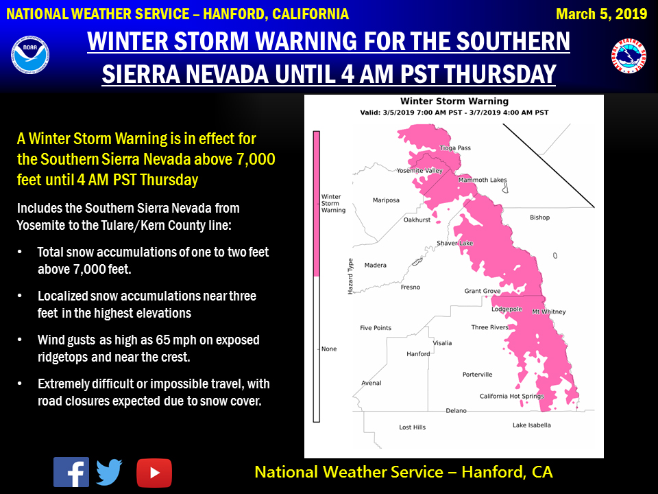
March 5, 2019 - The National Weather Service Hanford Office reports a Winter Storm Warning is in effect for the Southern Sierra Nevada from Yosemite to the Tulare/Kings County line above 7,000 feet until 4:00 A.M. Thursday.
Snow levels will be above 7,000 feet today through Wednesday morning, before gradually lowering to around 6,000 feet Wednesday afternoon.
Motorists should anticipate lengthy delays and slick, hazardous road conditions, as well as road closures above 7,000 feet.
If traveling, consider alternate plans and remember to carry tire chains, plenty of food, a good deal of water, and warm clothing.
For information on road conditions, including closures or delays, call Caltrans at 1-800-427-7623 or visit http://www.dot.ca.gov/cgi-bin/roads.cgi.
Winter Storm Warning
URGENT - WINTER WEATHER MESSAGE
National Weather Service Hanford CA
434 AM PST Tue Mar 5 2019

Sierra Nevada from Yosemite to Kings Canyon-
Tulare County Mountains-
434 AM PST Tue Mar 5 2019

...WINTER STORM WARNING REMAINS IN EFFECT UNTIL 4 AM PST THURSDAY
ABOVE 7000 FEET...

* WHAT...Heavy snow expected above 7000 feet. Total snow
  accumulations of 1 to 2 feet expected. Local amounts could
  reach as high as 3 feet at higher elevations. Winds gusting as
  high as 55 mph.

* WHERE...Sierra Nevada from Yosemite to Kings Canyon and Tulare
  County Mountains.

* WHEN...From 7 AM PST today to 4 AM PST Thursday.

* ADDITIONAL DETAILS...Travel could be very difficult to
  impossible. The hazardous conditions could impact the morning
  or evening commute. Gusty winds could bring down tree branches.

PRECAUTIONARY/PREPAREDNESS ACTIONS...

A Winter Storm Warning for snow means severe winter weather
conditions will make travel very hazardous or impossible. If you
must travel, keep an extra flashlight, food and water in your
vehicle in case of an emergency.

The latest road conditions for the state you are calling from can
be obtained by calling 5 1 1.
Source: NWS

