


Continued wet and cool in early March, but precipitation trending closer to normal by spring.
Warmer than normal temperatures next 4 months.
Potential for an active grass fire season late May into June.
Weather Discussion
March 5, 2019 - Cool, wet conditions continued across the Geographic Area this past month. The longwave pattern over the Eastern Pacific remained highly amplified, which allowed storm
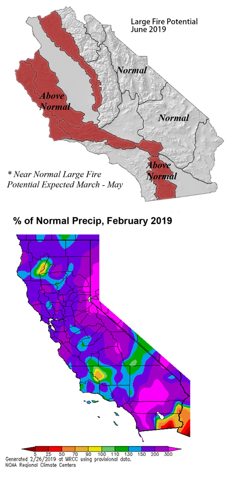 systems to frequently impact the state. While seemingly all of February’s storms were exceptionally wet, some of them were “warm” and had a tropical connection (atmospheric river) while others were of a Canadian Maritime origin. The resultant precipitation in February was well over 150% of normal in all but the far southeastern deserts.
The weather events which will be best remembered may be the very low snow levels seen during the storms of the second and third week of the month. One storm brought heavy snow to Redding in the northern part of the state dropped southward, producing snow accumulation down to approximately 1,200 feet across Southern California. A few snow showers even appeared at the immediate coast for the first time in decades (for areas south of Pt. Conception). The cold air wasn’t confined to just this aberration of a storm; this past month is first February in the 140+ year history of the Los Angeles Civic Center without temperatures reaching 70 degrees or higher.
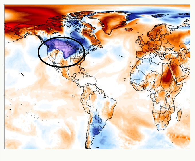
The below normal temperatures in California so far this year is part of a larger area cold air which has been present over much of North America. The cold area in the West was expected to flip positions with the warm weather back east a few weeks ago, but that did not happen. If anything, the trough over the West Coast deepened and retreated westward which allowed a wet, southwest flow to develop across the state. But at other times, some of the strongest temperature anomalies in the northern hemisphere were found over the Continental U.S. as seen in the snapshot below of a day in late February.
So given the poor performance of the models earlier this year, confidence in the long term forecast is below average at the current time. There are few noticeable, obvious trends overall in terms of sea surface temperatures or telltale signs in the ENSO which could drive the atmospheric patterns. But most long term models depict near to slightly above normal precipitation during the next 3 months. Much of March may continue to be wet and cool, but judging by a month to month breakdown of models covering the next few months, the traditional “rainy season” may conclude with less stormy weather than we’ve seen lately.
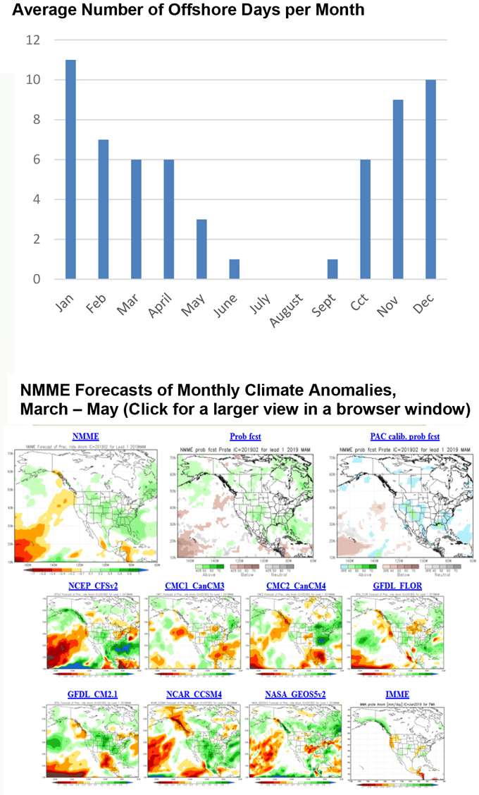
Offshore wind events have been close to non-existent so far this year. Cold air overhead or poised offshore is generally not a pattern conducive for offshore wind events. Unless the pattern of a warm West/cold East dipole pattern emerges, offshore wind events may be close to a near normal number, or perhaps a bit below normal through April.
FUELS AND DROUGHT OUTLOOK
Given the wet, cool winter, one might first assume that an increasingly dense and heavy grass crop is coming up at lower elevations. This is the case over much of Southern California, but anecdotal evidence points to a bit less grass growth one would expect so far this winter over Central and Northern California. The extremely cold temperatures – and freezing conditions at low elevations – may be partially responsible for the disparity between the current grass crop and ones seen during wet years. But with the expectation of warmer weather in March and April along with good subsoil moisture, a bumper grass crop is still likely over most areas below 3,000 feet by the spring. The desert and nearby areas will likely see another “superbloom” this spring (unless strong onshore spring winds deflower the vegetation).
Given the exceptionally high amounts of fuel moisture in all fuel types, it will be quite some time before conditions become dry enough to support large fire activity. It will likely be the latter half of summer before “meltout” occurs in the Sierra. Other wet years, such as 2010-2011, fire activity was extremely limited above 8,500 feet. A similar lack of fire activity is expected again this summer in alpine areas. Fires which do reach the higher elevations such as those moving eastward from the Sierra Foothills may see a sudden drop in fire activity if fire fronts venture close to these wet areas.
The most likely scenario for fire activity this spring may be a late start to grass fire season due to very wet soils, with the possibility a sudden upswing in large fires once the fine dead fuels dry out and seasonal grasses cure. Once this occurs, larger and more difficult to control fires may result if starts occur in areas where there is a high amount of dead vegetation such as the central coast and mountains of Southern California. The spring fire season may mirror what occurred in the wake of the wet 2016-2017 rainy season when fires such as the Detwiler occurred in an areas of bug killed timber. While the grass fire season may start quietly due to the lag in drying fine fuels (Below), areas from 2,000 to 6,500 feet may see a sudden surge in fire activity by June.
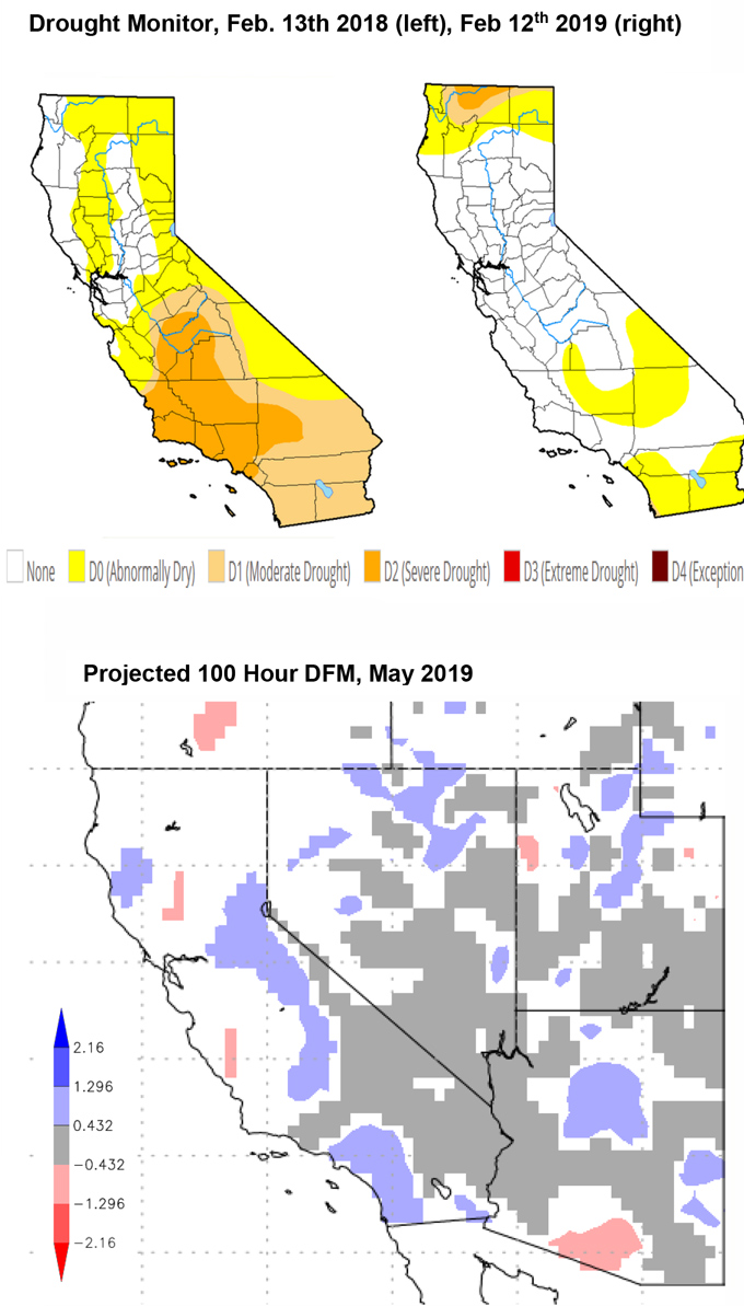
What is more certain is the widespread and significant reduction in the severity of the drought across California. Only a few areas in the Geographic Area are in a D0 drought (left, above). Snowpack is nearly 150% of normal which should keep reservoir storage full heading into the summer.
Credit for the contents of this outlook: Firebuster – Created by PSW Fire Lab; Drought Monitor – USDA, NOAA, Univ. of Nebraska; California Weather Blog - Dr. Daniel Swain; California Climate Data Archive – DRI, NOAA, CNAP; ClimateReanalyzer .org - CCI, Univ. of Maine
Source: Predictive Services

