


California and National Drought Summary for March 5, 2019
Summary
March 7, 2019 - Bitterly cold conditions settled over central portions of the nation, while stormy weather prevailed over parts of the eastern and western U.S. The Southeastern rain afforded localized relief from dryness, while a continuation of the west’s stormy weather pattern brought more drought relief to locales from the Pacific Coast into the Rockies. In contrast, short-term dryness intensified across the southcentral U.S., in particular central Texas.
Northeast
Colder-than-normal weather with rain and snow were reported across the region. There are currently no areas of Abnormal Dryness (D0) or drought in the Northeast.
Southeast
Widespread moderate to heavy rain was reported, with cooler-than-normal conditions (1-4°F below normal) in northern portions of the region contrasting with above-normal temperatures (5-10°F above normal) in the south. Interior portions of the Southeast remained free of drought, with 90-day precipitation averaging 150 to locally more than 200 percent of normal. The Abnormal Dryness (D0) along the South Carolina Coast and environs remained untouched despite locally more than an inch of rain; 60-day precipitation in this D0 area remained at or below 50 percent of normal. The D0 along the eastern coast of Florida experienced highly variable conditions, with 2 to 10 inches of rain eradicating Abnormal Dryness between Fort Lauderdale and West Palm Beach. The remainder of Florida’s D0 largely missed the rain, with significant precipitation departures (locally less than 50 percent of normal) noted over the past 180 days.
South
Cooler weather arrived, with heavy rain in eastern portions of the region in sharp contrast to increasingly dry conditions farther west. Rainfall in southern Louisiana’s Abnormal Dryness (D0) areas totaled 1 to 4 inches, easing or eliminating concerns over developing dryness; after discussions with local experts, the coastal D0 was removed. Pockets of dryness linger along the central Gulf Coast at varying time scales, and this region will need to be monitored closely over the upcoming weeks. Locally heavy showers (1-2 inches) in southern Texas also led to the reduction of D0 and Moderate Drought (D1). However, the story across the remainder of central and northern Texas was intensifying short-term dryness and drought. Over the past 60 days, large expanses of the state have received less than 50 percent of normal rainfall, with the expanded D1 areas reporting 10 percent of normal precipitation or less. However, there remains a sharply divergent signal at 90 days, with wet conditions (100-150 percent of normal) noted from San Antonio to Wichita Falls. This antecedent wetness has helped to forestall—for now—an even greater expansion of D0 and D1. However, if rain does not materialize soon across Texas, impacts of dryness and drought will rapidly develop as seasonably warmer weather arrives.
Midwest
The Midwest remained free of drought, with bitter cold (up to 20°F below normal) accompanying a deep snowpack in western and northern portions of the region.
High Plains
Most of the High Plains remained free of dryness and drought, with a moderate to deep snowpack coincident with temperatures averaging more than 20°F below normal. However, western portions of this region (notably, the mountains) continued to experience significant recovery from long-term Moderate (D1) to Severe (D2) Drought. During the 7-day monitoring period, precipitation totaled 1 to locally more than 3 inches (liquid equivalent) from the Park Range in northern Colorado to the San Juan Mountains in the south. Water-year precipitation has totaled 100 to 150 percent of normal, and mountain snow water equivalents (SWE) are in the 75th to the 100th percentile, indicative of favorable spring runoff prospects. The lingering drought remains most apparent in the longer term, with 24-month precipitation still averaging 50 to 75 percent of normal in the region’s D1 and D2 areas.
West
The ongoing recovery from long-term drought continued over much of the west, though dry conditions lingered over northern- and southern-most portions of the region.
In the Four Corners States, locally heavy precipitation (1-4 inches, locally more) in northern portions of the region afforded relief from Moderate to Extreme Drought (D1-D3) from the central Rockies into northern New Mexico. Water-year precipitation has totaled an impressive 110 to 225 percent of normal over most of the Four Corners, with below-normal precipitation confined to southwestern and northwestern New Mexico. Spring runoff prospects are likewise favorable, with mountain snow water equivalents (SWE) currently at or above the 70th percentile, save for subpar SWE in the Gila Mountains. The Four Corner’s drought is mostly apparent in the longer-term, with 24-month precipitation averaging 55 to 75 percent of normal in the region’s core drought areas.
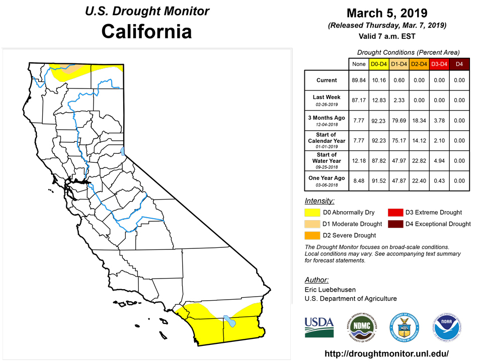
Farther north, heavy rain and mountain snow continued to slam locations from the northern California Coast into the northcentral Rockies. Precipitation over the past 7 days totaled an impressive 2 to 10 inches (locally more) from San Francisco north into the southern Cascades and east to the Sierra Nevada. Outside of a few locales in the southern San Joaquin Valley and in the far north, almost all of California is now reporting precipitation surpluses for the water year. To further illustrate, California’s disappearing Moderate Drought (D1) was limited to small portions in the far north, while Abnormal Dryness (D0) was confined to relatively small sections in northern and southern portions of the state. The wet weather in the north has also afforded additional drought relief in southwestern Oregon, with water-year deficits nearly eradicated from Medford into the southwestern Harney Basin. Despite the overall wet weather pattern, the water year has featured sub-par precipitation (70-80 percent of normal) in the central and northern Cascade Range. Snowpacks are in good to excellent shape in the Sierra Nevada (80th-98th percentile), southern Cascades (60th-92nd percentile), and from the Great Basin into the northcentral Rockies (55th-100th percentile). Conversely, subpar snowpacks remained a concern in the northern Rockies (locally below the 20th percentile) and northern Cascades (10th-30th percentile).
Alaska, Hawaii, and Puerto Rico
Drought conditions remained unchanged in Alaska. While snowpacks remained unfavorably low in the south (on the Kenai Peninsula, where snow water equivalents are at or below the 10th percentile), this has been largely due to warmth; water-year precipitation is near to above normal in these same locales. In Hawaii, another week with locally heavy showers (an inch or more in windward locations) as well as assessment from the field supported an additional 1-category reduction in drought intensity on the islands. In Puerto Rico, precipitation deficits continued to mount, with 90-day rainfall less than 70 percent of normal in the region’s expanded Moderate Drought (D1) areas. Furthermore, information from local experts indicated a variety of impacts, including declining reservoir levels, vegetation stress, and an increase in grass fires.
Looking Ahead
A stormy weather pattern will continue over much of the nation. A series of fast-moving Pacific storms will bring significant precipitation to most of the contiguous U.S., save for parts of the Gulf Coast States, southern California, and from the northern High Plains into the upper Midwest. Fresh snowfall is likely from the Cascades and Sierra Nevada into the Rockies, while another round of moderate to heavy snow may also blanket locales from the central High Plains into the Great Lakes Region. Potentially moderate to heavy rain is also in the offing from the southern Plains into the lower Ohio Valley. The NWS 6- to 10-day outlook for March 12–16 calls for above-normal precipitation across the entire nation, except for drier-than-normal conditions from California into the northern Rockies. Colder-than-normal weather over the western half of the nation will contrast with above-normal temperatures east of the Mississippi.
Author(s):
Eric Luebehusen, U.S. Department of Agriculture
Dryness Categories
D0 Abnormally Dry—used for areas showing dryness but not yet in drought, or for areas recovering from drought.
Drought Intensity Categories
D1 Moderate Drought
D2 Severe Drought
D3 Extreme Drought
D4 Exceptional Drought
Drought or Dryness Types
S Short-Term, typically less than 6 months (e.g. agricultural, grasslands)
L Long-Term, typically greater than 6 months (e.g. hydrologic, ecologic)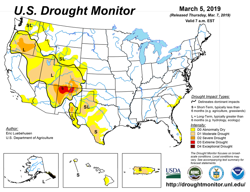
Source: National Drought Mitigation Center

