


California and National Drought Summary for March 26, 2019
Summary
March 28, 2019 - Dryness and drought intensified across parts of the South, while the overall trend toward drought recovery continued in the Four Corners region. Elsewhere, dryness concerns increased in the Northwest where drought expanded slightly; rain and snow will be needed soon across the northwestern quarter of the nation to prevent the region from slipping further into drought. Most of the nation from the central and northern Plains to the Mid-Atlantic and Northeast remained free of drought, with severe flooding the primary concern in the nation’s heartland.
Northeast
Cooler-than-normal weather with heavy rain and mountain snow were reported across the region, with 7-day precipitation topping 3 inches over Maryland and southern Pennsylvania. There are no areas of Abnormal Dryness (D0) or drought in the Northeast.
Southeast
The recent and pending rain in southern and eastern portions of the region fell after the Tuesday morning data cutoff and will be included in next week’s assessment. During the monitoring period, heavy rain in northern portions of the region contrasted with intensifying dryness in drought farther south. Rain totaled 1 to 3 inches from central and eastern North Carolina into northern Virginia, with reports topping 3 inches west of the nation’s capital. Likewise in eastern Florida, locally heavy showers (1-3 inches) near Cape Canaveral led to a small reduction of the state’s eastern Abnormal Dryness (D0); the rest of Florida’s coastal D0 was still wrestling with notable deficits over the past 9 months (50-70 percent of normal). Meanwhile, D0 and D1 (Moderate Drought) were expanded from the northeastern Gulf Coast into the southern half of South Carolina. Rainfall over the past 60 days has totaled a meager 30 to 50 percent of normal in the aforementioned areas, locally less than 30 percent from east-central Georgia to the South Carolina Coast. Impacts are still relatively minor, though streamflows have dropped below the 10th percentile in the driest locales.
South
Rain in the north contrasted with intensifying dryness in southern portions of the region. Moderate to heavy showers (1-2 inches, locally more) were noted from northern Texas and western Oklahoma southeastward into the northern and central Delta, resulting in a slight reduction of the northern Texas Abnormal Dryness (D0). Additional reductions to the southern Plains’ D0 were made based on input from local experts, indicating additional benefits from the previous week’s rainfall. Conversely, increasingly dry conditions in Texas have been noted over the past 60 days from Childress southward toward Laredo and Corpus Christi, with 90-day rainfall tallying a meager 20 percent of normal in the state’s expanded Severe Drought (D2) areas. Farther east, a highly variable signal is evident from Austin, Texas, eastward to New Orleans, Louisiana; 90-day rainfall has averaged near to above normal in these locales, while 60-day precipitation was below half of normal (locally less than 30 percent).
Midwest
The Midwest remained free of drought, with significant flooding impacting the Mississippi River and its tributaries.
High Plains
The primary concern on the High Plains centered on locally severe flooding in the Missouri River Basin, though localized dryness intensified in some western locales. Moderate to heavy rain (1-2 inches) eliminated the lingering pockets of Abnormal Dryness (D0) in northeastern Colorado and western Nebraska, while a continuation of wet weather (0.5-1 inch) in east-central Colorado facilitated the reduction of D0 east of Colorado Springs. Meanwhile, another round of moderate to heavy snow across central and western Colorado pushed mountain snowpack Snow Water Equivalents (SWE) to record or near-record levels (approaching or reaching the 100th percentile); as a result, additional reductions to the lingering long-term D0 and Moderate Drought (D1) were made. Note the drought over much of the Four Corners is almost exclusively now long-term (L) drought, with deficits most pronounced at 24 months (50-80 percent of normal) and beyond. Despite the overall trend toward drought removal on the High Plains, pronounced short-term dryness over the past 60 days (20-50 percent of normal) east of the Bighorn Mountains led to a small increase in D0 in north-central Wyoming.
West
Increasingly dry conditions in the Northwest contrasted with additional recovery from long-term drought from the Great Basin into the central and southern Rockies.
Across central and southern portions of the region, moderate to heavy precipitation (0.5 to more than 1 inch) fell from Nevada east-southeastward into Colorado and northeastern New Mexico. This week’s precipitation—on top of last week’s rain and snow—as well as input from local experts led to widespread reduction of the southern High Plains’ Abnormal Dryness (D0). Across northern New Mexico and southern Colorado, precipitation over the past two weeks has totaled an impressive 1 to 5 inches (liquid equivalent), pushing mountain Snow Water Equivalents (SWE) toward record levels (80-100th percentile) and begetting notable reductions in drought intensity and coverage. Similar SWE were reported across Utah and Nevada, with corresponding decreases to the lingering D0 and Moderate Drought (D1). Note the drought over much of the Four Corners is almost exclusively now long-term (L), with deficits most pronounced at 24 months (50-80 percent of normal) and beyond.
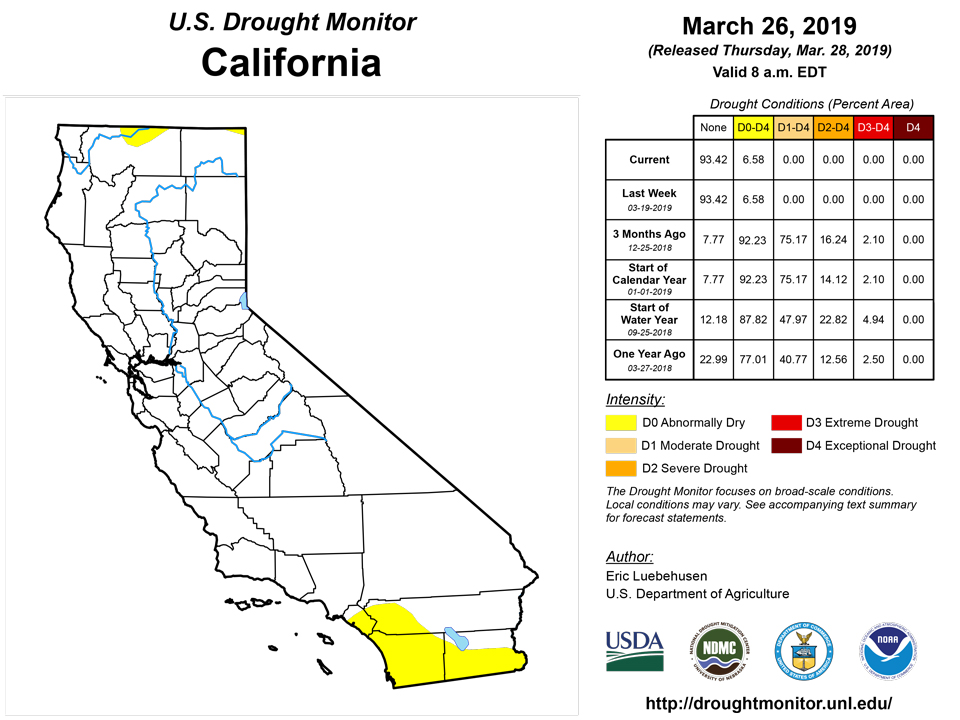
Farther north, a drought-free California contrasted with increasingly dry conditions across the Northwest and northern Rockies. Changes to the Northwestern drought depiction were minor and confined to small increases of D0 and D1 in northern and western Washington. However, local experts are becoming concerned as water-year precipitation (70-80 percent of-normal) has been subpar in the central and northern Cascade Range and environs, exacerbated by acute short-term dryness (60-day precipitation totaling 30 to 50 percent of normal in Washington, slightly more in northwestern Oregon). Furthermore, snowpacks remained much lower than those seen farther south, with SWE in the 10th to 30th percentile over much of Washington, northern Idaho, and western Montana.
Alaska, Hawaii, and Puerto Rico
Drought conditions were unchanged in Alaska. While snowpacks remained unfavorably low on the Kenai Peninsula (Snow Water Equivalents (SWE) at or below the 25th percentile), this has been largely due to warmth; water-year precipitation has been near to above normal in these same locales. In southeastern Alaska, acute short-term dryness is raising the specter of intensifying drought, with 60-day precipitation averaging 50 percent of normal or less in the state’s Severe Drought (D2) areas. In Hawaii, acute dryness in March following a wet February led to widespread expansion of D0. In particular, 30-day rainfall deficits of 2 to 5 inches (2-33 percent of normal) are common across the islands from Kauai to Hawaii. Conversely, showers increased on Puerto Rico, though rain was not yet sufficient to cut into the Abnormal Dryness (D0) and Moderate Drought (D1).
Looking Ahead
An unsettled weather pattern will continue over much of the nation. A pair of Pacific storms are expected to bring much-needed rain and mountain snow to the Northwest and northern Rockies. As the lead system marches east, it will produce rain and snow from the central Plains into the Midwest, though the Upper Midwest will remain dry. Increasingly stormy weather is also in the offing for the East Coast States, with the greatest chances for heavy rain noted along Florida’s eastern coast and from the Carolinas into the Mid-Atlantic region. Mostly dry weather is expected from the lower Four Corners into central Texas, while showers may return to southern Texas. The NWS 6- to 10-day outlook for April 2–6 calls for near- to above-normal precipitation across most of nation, save for pockets of dryness in the Southwest and central Gulf Coast region; drier-than-normal conditions are also expected over Alaska. Colder-than-normal weather over northern portions of the Plains and Upper Midwest will contrast with above-normal temperatures in northern- and southern-most portions of the Atlantic Coast States and from the Four Corners into the Northwest and Alaska.
Author(s):
Eric Luebehusen, U.S. Department of Agriculture
Dryness Categories
D0 Abnormally Dry—used for areas showing dryness but not yet in drought, or for areas recovering from drought.
Drought Intensity Categories
D1 Moderate Drought
D2 Severe Drought
D3 Extreme Drought
D4 Exceptional Drought
Drought or Dryness Types
S Short-Term, typically less than 6 months (e.g. agricultural, grasslands)
L Long-Term, typically greater than 6 months (e.g. hydrologic, ecologic)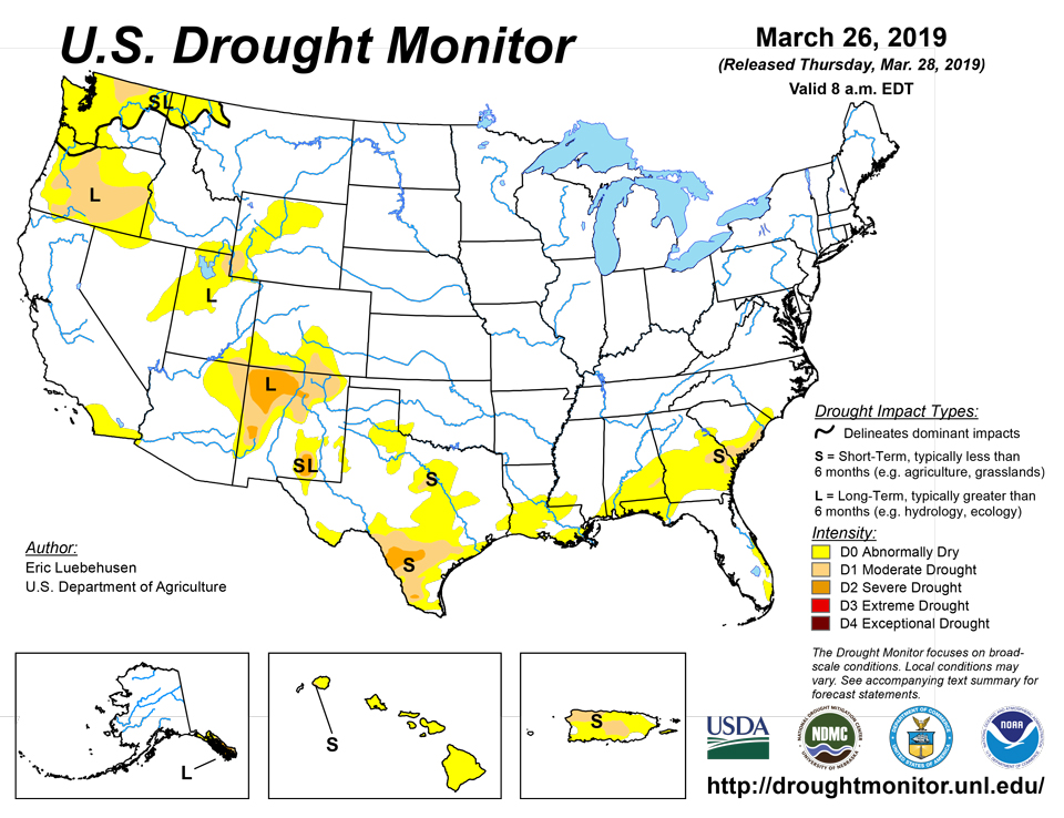
Source: National Drought Mitigation Center

