


Max temperatures near to slightly below normal along the coast, but closer to normal further inland.
Near to slightly below normal number of summer thunderstorms outside the deserts.
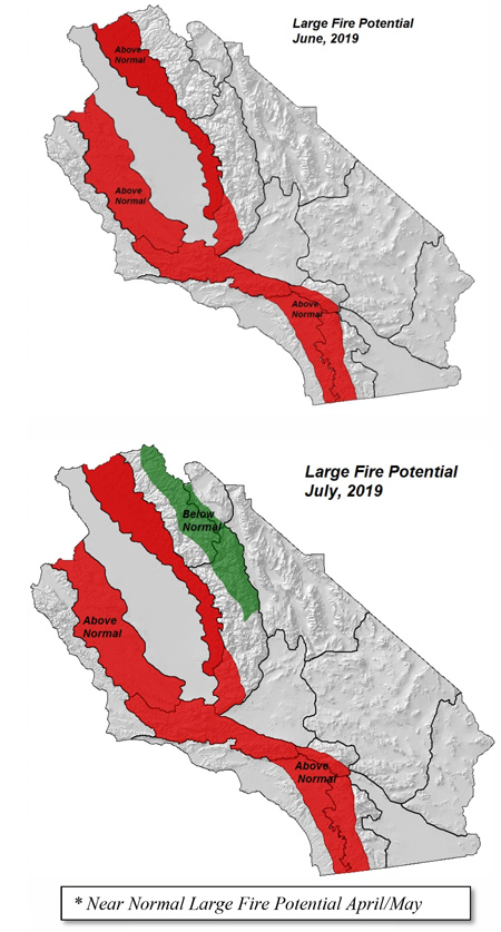
Large fire potential trending above normal this summer in the foothills and inland valleys due to tree mortality.
Greatest large fire potential in the Sierra Foothills again this summer.
Weather DIscussion
April 2, 2019 - After an extremely wet January and February, precipitation begin to decrease in March, especially over the southern third of the state. The number and vigor of the storm systems
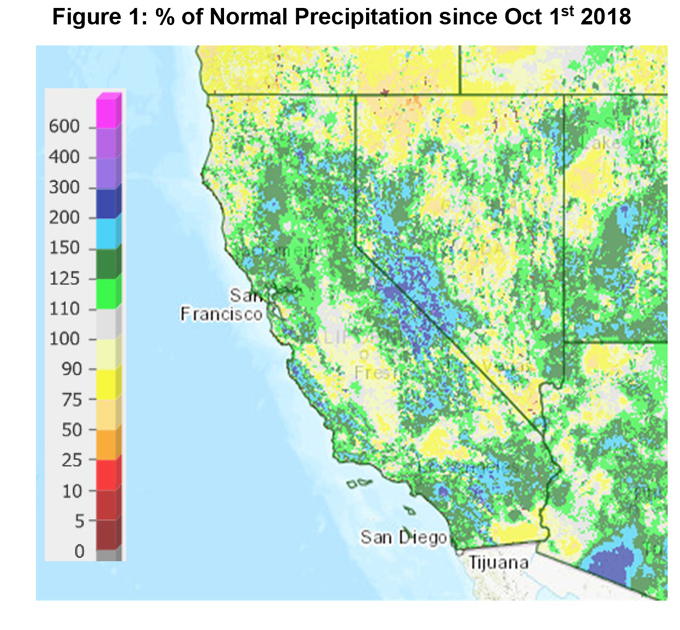
 arriving in California begin to wane, as is typically the case, toward the end of the month. Still, as a whole, the state finished with far above normal precipitation in March from Monterey and Fresno County northward. Southern California saw lesser amounts, but rainfall was highly variable over much of that area due to the convective nature of the precipitation. For the winter, much of the area outside the desert received 150-300% of normal precipitation (Figure 1, below).
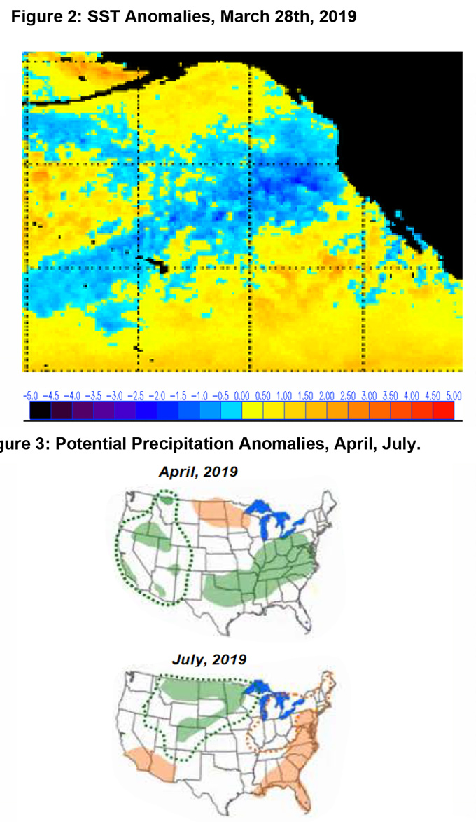
The heavy rainfall this winter has been generated, in part, by the high amount of moisture availability across the eastern Pacific (“Atmospheric River”). This moisture source will become less important in producing precipitation going forward this spring as most storms will remain too far north of the area to scoop this moisture. But some of the longwave patterns which have been responsible for the rainfall look to remain in place for a few more weeks, namely the strong blocking ridge in the Eastern Pacific. This ridge has brought record heat to Alaska at times this winter and has been of such a high amplitude as to allow the storm track to undercut it to the south. This has translated into above normal precipitation for the Southwest and most of California the past few weeks.
Although most of the seasonal rainfall across the area is coming to an end, it appears likely the southwest flow which has been present the past few weeks will continue into April and May. This may result in onshore flow and slightly below normal temperatures, especially near the coast the next few weeks.
Looking further ahead into June and July, most indices are flat at the current time with the MJO, NAO, PNA all showing little influence. The ENSO index, interestingly, continues to show a slow strengthening of the current weak El Niño through the summer which is a bit unusual.
A positive ENSO may result in a greater amount of moisture availability for the “summer monsoon”, but most models indicate the bulk of the monsoonal moisture will remain to our east in the central Rockies and Midwest. (Southwest flow, should it continue into the summer is not conducive for sustained monsoonal flow across California)
Therefore, we are expecting a below normal number of thunderstorms over the district this summer. There should be a fewer number of days with thunderstorms with a lesser chance of them being dry thunderstorms.
A lack of La Niña and southwesterly flow aloft ordinarily result in a fewer than normal offshore wind events. Therefore, expect offshore wind episodes to occur less frequently and be of shorter duration than normal the remainder of the spring. In general, expect 2-3 offshore wind events in April and 1-2 in May this year.
FUELS AND DROUGHT OUTLOOK
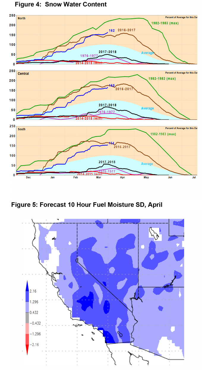
The heavy rain at lower elevations with a deep layer of snow in the mountains has improved the hydrological situation across the state greatly since the fall of 2018. Reservoirs are nearly full at the current time and the most important watersheds in the state are showing over 150% of normal snowpack for April 1st. Snow water content in the Sierras is on par with the heavy snow season of 2016- 2017 (Figure 4, below).
This moisture will go a long way in determining the upcoming “fire season” as both live and dead fuels are indicating well above normal amounts of fuel moisture at the current time. Subsoil moisture will be adequate to maintain the heavier live fuels well into spring and the early summer months.
The chief concern this spring, like may wet years, will be the potential for a spike in grass fire activity. There is a heavy grass crop standing over many areas below 3,000 feet, especially over Southern California which has seen an optimal mix of rain and sun to spur growth. Inevitably these fuels will cure from south to north this spring and be available for burning in May and June. While fuel conditions may support above normal grass fire activity, weather patterns may not align favorably for above normal large fire activity until late May or early June. This represents a 2-4 week lag in the usual spike in grassfire activity to account for the expectation of below normal temperatures and a lesser chance of offshore wind events.
A tremendous number of acres of dead or dying vegetation remains over the Sierras Foothills and the central coast due to the bark beetle and the multiyear drought. Once these heavier fuels dry out, fires may transition quickly from the cured grasses into higher elevations with larger diameter fuels. This was the case the past few years in such incidents as the Sobranes, Erskine, Ferguson and the Detwiler Fires. Conversely, the higher elevations of the Sierras (~8,500 and higher) may not see much fire activity this year due to the heavy snowpack which may last into the latter stages of summer. In all, large fire potential may climb quickly in June with the highest threat likely being in the Sierras foothills once again due to the overlap of heavy, cured grasses and a high density of tree mortality in this area.
Source: Predictive Services

